- Labweh
-
Neolithic Labweh 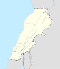
 Shown within Lebanon
Location 26 kilometres (16 mi) North-east of Baalbek Region Bekaa Valley Coordinates 34°11′50″N 36°21′09″E / 34.197317°N 36.352392°E Type Tells Part of Settlements History Founded c. 6910 to 6780 BC (from 3 limited samples) Periods PPNB Cultures Neolithic, Roman, Byzantine Site notes Excavation dates 1966, 1969 Archaeologists Diana Kirkbride, Lorraine Copeland, Peter Wescombe Condition Ruins Public access Yes Labweh (Arabic: اللبوة), Laboue, Labwe or Al-Labweh is a village at an altitude of 950 metres (3,120 ft) on a foothill of the Anti-Lebanon mountains in the Baalbek District of Lebanon.[1][2]
Contents
History
The Neolithic settlements represented at Labweh have been found dating to at least the 7th millennium BC. It has been suggested that it was known to the Egyptians as Lab'u, to the Assyrians as Laba'u and as Lebo-hamath to the Hebrews. This has been associated with the Hamath mentioned in the Book of Kings and the Book of Ezekiel noted as the Northern border of King Solomon's territory.[3] Labweh in the original Syraic tongue means "heart" or "center", it also has been suggested to come from the Arabic for "lion" or "lioness". The village has several archaeological sites of interest including three old caves with Roman-Byzantine sarcophagi and the remains of a temple. There are also remains of a Byzantine bastion and a Roman dam suggested to date to the reign of Queen Zenobia. Legend suggests that channels were carved through the rock to send water to her lands in Palmyra, Syria.[1]
Labweh Springs and Labweh River
The village is located on a hill 26 kilometres (16 mi) northeast of Baalbek, which gives its name to the Labweh Springs and Labweh River, one of the sources of the Orontes.[2] The Labweh river flows for approximately 12 miles (19 km) through rocky desert. It then cascades into a lake and wider stream at another village called Er-Ras, considered to be the source of the Orontes. This flows onwards northeast, fed by numerous other streams from Lebanon's mountains.[4][5]
Archaeological sites
Soundings and analysis of archaeological sites in Labweh were made by Lorraine Copeland and Peter Wescombe in 1966 with later excavations by Diana Kirkbride in 1969.[6] Tell Labweh, Tell Labweh South or Labweh I sits to the South of the village with another site to the North. The surface of Tell Labweh had been damaged by modern agriculture and it had been cut in half by road construction. Several burials were discovered inside the remains of rectangular buildings with white and red plaster floors. The remains of stone walls were found at lower levels and it is thought that the buildings may have used mud bricks at higher levels.[7]
Early neolithic finds included a large number of fragments of limestone White Ware or "Vassille Blanche", along with later pottery called dark faced burnished ware or DFBW. Only one vessel was reconstructed from the initial excavations; a bowl with combed finishing. Other shards included jars and bowls of a black, brown or red colour, one showed a straw wiped finish normally found in sites further South in the Jordan Valley. Others showed decorations such as chevrons, incised patterns and corded impressions.[7] Flints were similar to those found at Tell Ramad and included Byblos points, hooks, scrapers, borers and burins. Burials were found within two houses, which were excavated and found to be similar to those in earlier PPNB and PPNA sites. A range of sickle blades were found in the basal deposits and higher levels showing the evolution of denticulated and segmented cutting edges with similarities to those found at the oldest neolithic Byblos. Three initial samples were Radiocarbon dated suggesting a range of dates between 6780 to 6910 BC; a date range covering only c. 130 years.[8] The range of finds at the site has however helped to reveal some aspects of the transition through neolithic stages.[7]
Tell Labweh North is another large archaeological site, a few hundred metres north on the other side of the village and springs. Finely denticulated sickle blades, arrowheads and trapezoidal, flaked axes and fragments of white ware along with burnished pottery with patterns and a fragment of obsidian were collected from the surface of the site. Most of the finds indicated settlement around the time of Tell Labweh (South) and Byblos.[7] Fauna would have included forest animals and numerous domesticated cattle, sheep and goats.[9]
Literature
- Kirkbride, Diana., Early Byblos and the Bakaa, Volume 45 (Pages 43-60), Mélanges de l'Université Saint-Joseph (Beirut Lebanon), 1969.
- Copeland, Lorraine and Westcombe, Peter., Inventory of Stone Age Sites in Lebanon Part 2: North - South - East Central Lebanon Volume 42 (Pages 1-174) Mélanges de l'Université Saint-Joseph (Beirut Lebanon), 1966.
References
- ^ a b Ba'albeck - Al-Hermal, Bekaa - Tourist Brochure
- ^ a b Royal Geographical Society (Great Britain) (1837). The journal of the Royal Geographic Society of London. J. Murray. pp. 99–. http://books.google.com/books?id=te8RAAAAYAAJ&pg=PA99. Retrieved 16 March 2011.
- ^ Daniel Isaac Block (March 1998). The Book of Ezekiel: chapters 25-48. Wm. B. Eerdmans Publishing. pp. 713–. ISBN 9780802825360. http://books.google.com/books?id=uYemhagtCpgC&pg=PA713. Retrieved 16 March 2011.
- ^ Sir. William Smith, LLD, Ed. Dictionary of Greek and Roman Geography (1854)
- ^ Society for the Diffusion of Useful Knowledge (Great Britain) (1842). Penny cyclopaedia of the Society for the Diffusion of Useful Knowledge. C. Knight. pp. 469–. http://books.google.com/books?id=GxwDAAAAYAAJ&pg=PA469. Retrieved 17 March 2011.
- ^ Zeidan Abdel-Kafi Kafafi (1982). The Neolithic of Jordan (East Bank). Papyrus Druck. http://books.google.com/books?id=RIdWAAAAMAAJ. Retrieved 16 March 2011.
- ^ a b c d Moore, A.M.T. (1978). The Neolithic of the Levant. Oxford University, Unpublished PhD Thesis. pp. 192–198. http://ancientneareast.tripod.com/Labweh.html.
- ^ University of Cologne - Radiocarbon Context Database
- ^ Richard H. Meadow; Melinda A. Zeder (1978). Approaches to faunal analysis in the Middle East. Peabody Museum of Archaeology and Ethnology, Harvard University. ISBN 9780873659512. http://books.google.com/books?id=HVMrAQAAIAAJ. Retrieved 16 March 2011.
 Archaeological sites in LebanonAadloun • Aaiha • Aammiq • Ain Harcha • Akbiyeh • Amioun • Anjar, Lebanon • Antelias cave • Ard Tlaili • Arqa • Baalbek • Batroumine • Batroun • Beirut • Beit Mery • Byblos • Dahr El Ahmar • Dakoue • Deir El Aachayer • Deir el Ahmar • Dekwaneh • Douris (Baalbek) • Elaea (Lebanon) • Hadeth south • Haret ech Cheikh • Hashbai • Hermel plains • Iaat • Jabal es Saaïdé • Jbaa • Jdeideh • Jebel Aabeby • Jeita Grotto • Joub Jannine • Jieh • Kamid al lawz • Kaukaba • Kefraya • Kfar Qouq • Kfarhata • Ksar Akil • Labweh • Lake Qaraoun (Ain Jaouze) • Lion Tower • Majdal Anjar • Mansourieh • Maronite mummies • Mayrouba • Moukhtara · Mtaileb · Nabi Zair • Nachcharini • Neba'a Faour • Niha Bekaa • Qaraoun • Ras Baalbek I • Ras Beirut • Ras El Kelb • Sands of Beirut • Sidon • Sin el Fil • Sarepta • Stone of the Pregnant Woman • Tahun ben Aissa • Tell Ain Nfaikh • Tell Ain Saouda • Tell Deir • Tell el-Burak • Tell Khardane • Tell Jisr • Tell Mureibit • Tell Neba'a Litani • Tell Zenoub • Tell Zeitoun • Temple of Bacchus • Temple of Eshmun • Toron • Tripolis (region of Phoenicia) • Tyre Necropolis • Tyre, Lebanon • Yanta • Ain W Zain • Zahlé • Lebanon topics
History 
Politics Constitution · President · Prime Minister · Political parties · Foreign relations · Military · Human rights (LGBT rights)Geography Mount Lebanon · Beqaa · Anti-Lebanon mountains · Cities · Governates · Districts · South Lebanon · Sheeba FarmsEconomy Central Bank · Transport · Tourism · Communications · Agriculture · International rankings · Lebanese PoundCulture WikiProject LebanonCapital: BaalbekTowns and villages  Categories:
- Populated places in the Beqaa Governorate
- Baalbek District
- Archaeological sites in Lebanon
- Great Rift Valley
- Phoenician cities
- Phoenician sites in Lebanon
- Roman colonies
- Ancient cities
- Ancient Levant
- Populated places established in the 7th millennium BC


Wikimedia Foundation. 2010.