- National Highway 36 (India)
-
National Highway 36

36
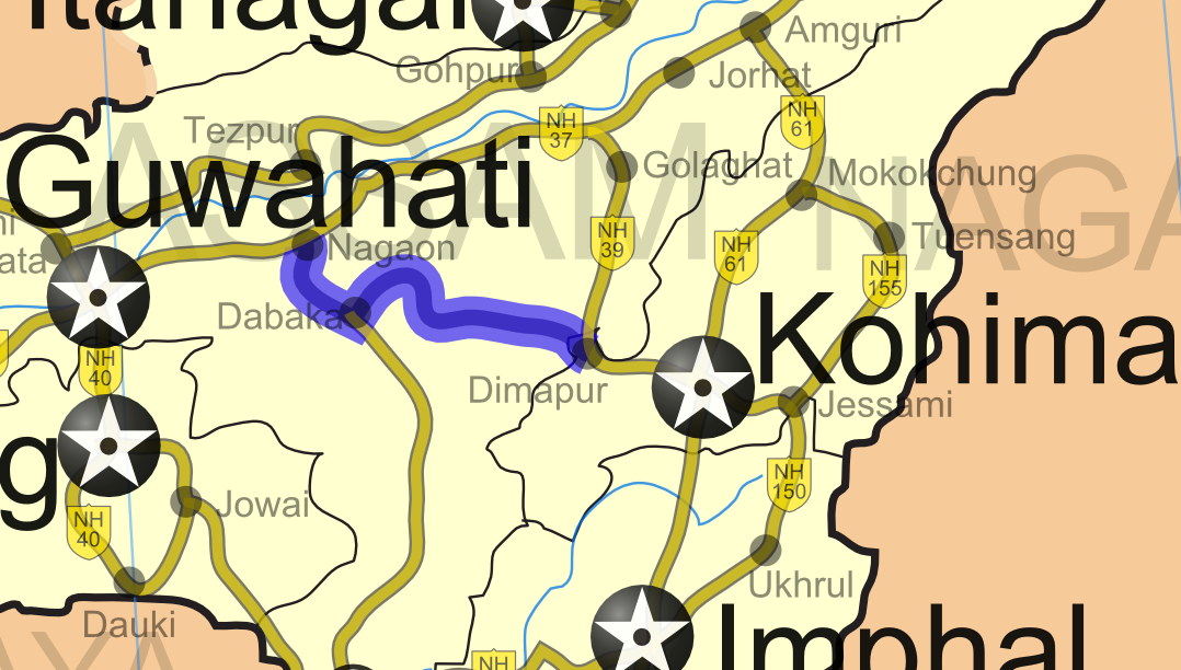
Road map of India with National Highway 36 highlighted in blueRoute information Length: 170 km (110 mi) Major junctions West end: Nagaon, Assam East end: Dimapur, Nagaland Location States: Assam: 167 km (104 mi)
Nagaland: 3 km (1.9 mi)Primary
destinations:Nagaon - Kathiatali - Dabaka - Amlakhi - Dimapur Highway system Indian Road Network
National • Expressways • State
State Highways in ¬← NH 35 NH 37 → National Highway 36, also known as NH 36, connects Nagaon in Assam and Dimapur in Nagaland. The total distance covered is 170 km (110 mi), of which 167 km (104 mi) is in Assam and 3 km (1.9 mi) is in Nagaland.[1]
It starts from the junction of NH 37 in Nagaon and ends in the junction of NH 54 in Dimapur.
Contents
Route
See also
- List of National Highways in India (by Highway Number)
- List of National Highways in India
- National Highways Development Project
References
External links
Indian Highways Network National Expressways NE 1 • NE 2


State Expressways Mumbai-Pune • Delhi-Gurgaon • DND Flyway • Bengaluru-Mysore • Chennai HSCTC • Hyderabad Elevated ExpresswaysNational Highways 1 • 1A • 1B • 1C • 1D • 2 • 2A • 3 • 4 • 4A • 4B • 5 • 5A • 6 • 7 • 7A • 8 • 8A • 8B • 8C • 8D • 8E • 9 • 10 • 11 • 11A • 11B • 12 • 12A • 13 • 14 • 15 • 16 • 17 • 17A • 17B • 18 • 19 • 20 • 21 • 21A • 22 • 23 • 24 • 24A • 24B • 25 • 25A • 26 • 26A • 27 • 28 • 28A • 28B • 28C • 29 • 30 • 30A • 31 • 31A • 31B • 31C • 31D • 32 • 33 • 34 • 35 • 36 • 37 • 37A • 38 • 39 • 40 • 41 • 42 • 43 • 44 • 44A • 45 • 45A • 45B • 45C • 46 • 47 • 47A • 47B • 47C • 48 • 49 • 50 • 51 • 52 • 52A • 52B • 53 • 54 • 54A • 55 • 56 • 57 • 57A • 58 • 59 • 59A • 60 • 60A • 61 • 62 • 63 • 64 • 65 • 66 • 67 • 68 • 69 • 70 • 71 • 71A • 71B • 72 • 72A • 73 • 73A • 74 • 75 • 76 • 77 • 78 • 79 • 79A • 80 • 81 • 82 • 83 • 84 • 85 • 86 • 86A • 87 • 88 • 89 • 90 • 91 • 91A • 92 • 93 • 94 • 95 • 96 • 97 • 98 • 99 • 100 • 101 • 102 • 103 • 104 • 105 • 106 • 107 • 108 • 109 • 110 • 111 • 112 • 113 • 114 • 116 • 117 • 119 • 121 • 123 • 125 • 126 • 127 • 128 • 129 • 150 • 151 • 152 • 153 • 154 • 155 • 200 • 201 • 202 • 203 • 203A • 204 • 205 • 206 • 207 • 208 • 209 • 210 • 211 • 212 • 213 • 214 • 214A • 215 • 216 • 217 • 218 • 219 • 220 • 221 • 222 • 223 • 224 • 226 • 227 • 228 • 229 • 234 • 235State Highways Andhra Pradesh • Arunachal Pradesh • Assam • Bihar • Chhattisgarh • Goa • Gujarat • Haryana • Himachal Pradesh • Jammu and Kashmir • Jharkhand • Karnataka • Kerala • Madhya Pradesh • Maharashtra • Manipur • Meghalaya • Mizoram • Nagaland • Orissa • Punjab • Rajasthan • Sikkim • Tamil Nadu • Tripura • Uttarakhand • Uttar Pradesh • West BengalNotable Categories:- National Highways in Assam
- National Highways in Nagaland
- Indian National Highways
- India road stubs


Wikimedia Foundation. 2010.