- Murray Basin
-
This article is about the geological basin. For the Murray Darling River catchment area, see Murray-Darling basin.
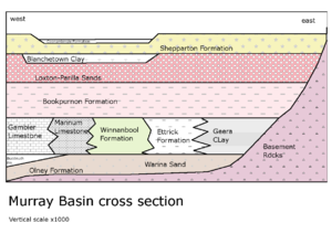
The Murray Basin is a Cenozoic sedimentary basin in south eastern Australia. The basin is only shallow, but extends into New South Wales, Victoria and South Australia. It takes its name from the Murray River which traverses the Basin from east to west.
After Australia separated from Antarctica the Murray Basin was formed. The basin floor only subsided slowly over time.[1] The basin became filled with up to 600 m of sediments during the Cenozoic.[2]
From Paleocene to Eocene the western side was flooded with sea water and deposited the Warina sand.[3] The sea withdrew and later in the Eocene silt and clay of the Olney Formation[4] were deposited. One minor sea incursion resulted in late Eocene resulted in the Buccleuch Formation[5] in South Australia. The is group of deposits is termed the Renmark Group and was earlier known as Knight Group.[6]
The sea level rose again in Late Oligocene to mid Miocene forming the Murray Group of sediments, with marl and limestone in the deeper locations, and the Geera Clay[7] in the shallow waters. The rock units formed in the deeper water included the Ettric Formation,[8] the Winnanbool Formation[9] and the Mannum Formation limestone[10] with Gambier Limestone in South Australia.[11][12] When sea level fell again in mid Miocene the deposited Geera clay and Olney Formation moved westward over the limestone.[1]
During Upper Miocene to Pliocene the sea rose and fell several times. The first sea rise formed the Murravian Gulf and resulted in clay and marl in the west called the Bookpurnong Formation,[13] and Calivil Formation[14] river and lake sand in the east. When the sea retreated in Early Pliocene, the Loxton Sands[15] also informally known as Loxton-Parilla Sands were formed on the beach on the shore of the emergent land. Locally heavy minerals have been concentrated by wave action including rutile zircon and ilmenite forming economic mining opportunities.[16]
 Lake Bungunnia around 1Mya
The Murray River became dammed by uplift of over 250 meters in the Grampians in Victoria during the Pleistocene about 2.5 Mya. The dam formed Lake Bungunnia, which reached 40000 km2 and deposited the Blanchetown Clay therein.[17] Higher rainfall of at least 500 mm per year kept the lake filled at first, but during later times rainfall was insufficient and saline lakes formed, depositing dolomite. Even today some saline lakes remain as a remanent of the vast lake.[18] The Murray River carved out a new path to the sea via Murray Bridge replacing its previous exit at Portland, Victoria. The lake was gone by about 0.7 Mya.
The Pooraka Formation[19] formed in the north west due to increased erosion resulting in colluvium depositing. The colluvium forms fans, cones and scree slopes, and often contains clay and breccia. In the flat areas the Shepparton Formation[20] also resulted from river deposits of floodplain clay.[1]
Most of the existing surface dates from Quaternary period. The river deposits from the east have been progressively overlaying the marine deposits further west, as the shore line receded. Within the Pleistocene deposits are three layers of sand that are aquifers, deposited during higher rainfall periods of the interglacials. The floodplain deposits from the current rivers are the Coonambidgal Formation, however this term is used informally for the older Pleistocene flood deposits as well.[21] During the dryer glacial periods the area was arid.[22]
References
- ^ a b c Robert A Kingham (1998). Geology of the Murray-Darling Basin — Simplified Lithostratigraphic Groupings. Australian Geological Survey Organisation. ISBN 0642273561. http://www.brs.gov.au/mdbsis/mdbgeol.pdf.
- ^ T.J. Munday et al (September 2004). "Combining Geology and Geophysics to Develop a Hydrogeological Framework for Salt Interception in the Loxton Sands Acquifer, Central Murray Basin, Australia". CRC LEME. http://crcleme.org.au/Pubs/OPEN%20FILE%20REPORTS/OFR%20171-180/OFR180.pdf. Retrieved 3 November 2010.
- ^ "Warina Sand". Australian Stratigraphic Names Database. Geoscience Australia. 3 February 2009. http://dbforms.ga.gov.au/pls/www/geodx.strat_units.sch_full?wher=stratno=19462.
- ^ "Olney Formation". Australian Stratigraphic Names Database. Geoscience Australia. 25 March 2008. http://dbforms.ga.gov.au/pls/www/geodx.strat_units.sch_full?wher=stratno=14553.
- ^ "Buccleuch Formation". Australian Stratigraphic Names Database. Geoscience Australia. 3 February 2009. http://dbforms.ga.gov.au/pls/www/geodx.strat_units.sch_full?wher=stratno=30504.
- ^ "Renmark Group". Australian Stratigraphic Names Database. Geoscience Australia. 29 July 2008. http://dbforms.ga.gov.au/pls/www/geodx.strat_units.sch_full?wher=stratno=16036.
- ^ "Geera Clay". Australian Stratigraphic Names Database. Geoscience Australia. 29 July 2008. http://dbforms.ga.gov.au/pls/www/geodx.strat_units.sch_full?wher=stratno=7090.
- ^ "Ettric Formation". Australian Stratigraphic Names Database. Geoscience Australia. 28 July 2008. http://dbforms.ga.gov.au/pls/www/geodx.strat_units.sch_full?wher=stratno=6337.
- ^ "Winnanbool Formation". Australian Stratigraphic Names Database. Geoscience Australia. 29 July 2008. http://dbforms.ga.gov.au/pls/www/geodx.strat_units.sch_full?wher=stratno=20250.
- ^ "Mannum Formation". Australian Stratigraphic Names Database. Geoscience Australia. 6 April 2010. http://dbforms.ga.gov.au/pls/www/geodx.strat_units.sch_full?wher=stratno=11187.
- ^ "Gambier Limestone". Australian Stratigraphic Names Database. Geoscience Australia. 7 April 2009. http://dbforms.ga.gov.au/pls/www/geodx.strat_units.sch_full?wher=stratno=6976.
- ^ Adrian Fabris. "Northwestern Murray Basin Stratigraphy Sedimentology and Geomorphology". South Australian Office of Minerals and Energy Resources. http://www.pir.sa.gov.au/__data/assets/pdf_file/0018/10890/mj27_murray_basin.pdf. Retrieved 3 November 2010.
- ^ "Bookpurnong Formation". Australian Stratigraphic Names Database. Geoscience Australia. 23 February 2009. http://dbforms.ga.gov.au/pls/www/geodx.strat_units.sch_full?wher=stratno=2203.
- ^ "Calivil Formation". Australian Stratigraphic Names Database. Geoscience Australia. 3 February 2009. http://dbforms.ga.gov.au/pls/www/geodx.strat_units.sch_full?wher=stratno=3322.
- ^ "Loxton Sands". Australian Stratigraphic Names Database. Geoscience Australia. 6 November 2010. http://dbforms.ga.gov.au/pls/www/geodx.strat_units.sch_full?wher=stratno=10827.
- ^ Peter S. Roy and John Whitehouse (August 2000). "Mineral Sands Occurrences in the Murray Basin, Southeastern Australia". Economic Geology 95 (5): 1107–1128. doi:10.2113/gsecongeo.95.5.1107. http://econgeol.geoscienceworld.org/cgi/content/abstract/95/5/1107#SEC2.
- ^ S. McLaren (March 2009). "Revised stratigraphy of the Blanchetown Clay, Murray Basin: age constraints on the evolution of paleo Lake Bungunnia". Australian Journal of Earth Sciences 56 (2): 259–270. doi:10.1080/08120090802547074. http://www.informaworld.com/smpp/content~content=a908851762.
- ^ A.E. Stephenson (December 1986). "Lake Bungunnia — A Plio-Pleistocene megalake in southern Australia". Palaeogeography, Palaeoclimatology, Palaeoecology 57 (2-4): 137–156. doi:10.1016/0031-0182(86)90011-8.
- ^ "Pooraka Formation". Australian Stratigraphic Names Database. Geoscience Australia. 22 June 2009. http://dbforms.ga.gov.au/pls/www/geodx.strat_units.sch_full?wher=stratno=15448.
- ^ "Shepparton Formation". Australian Stratigraphic Names Database. Geoscience Australia. 27 February 2009. http://dbforms.ga.gov.au/pls/www/geodx.strat_units.sch_full?wher=stratno=25474.
- ^ "Coonambidgal Formation". Australian Stratigraphic Names Database. Geoscience Australia. 17 June 2009. http://dbforms.ga.gov.au/pls/www/geodx.strat_units.sch_full?wher=stratno=4598.
- ^ S, Pels "The Murray Basin" in The Geology of NSW p506
Categories:- Sedimentary basins of Australia
- Murray-Darling basin

Wikimedia Foundation. 2010.