- Murcott, Oxfordshire
-
Coordinates: 51°50′28″N 1°10′05″W / 51.841°N 1.168°W
Murcott 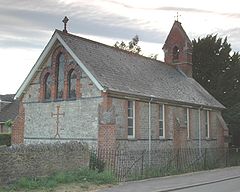

 Murcott
Murcott shown within OxfordshireOS grid reference SP5815 Parish Fencott and Murcott District Cherwell Shire county Oxfordshire Region South East Country England Sovereign state United Kingdom Post town Kidlington Postcode district OX5 Dialling code 01865 Police Thames Valley Fire Oxfordshire Ambulance South Central EU Parliament South East England UK Parliament Banbury List of places: UK • England • Oxfordshire Murcott is a village between the River Ray and Otmoor in the civil parish of Fencott and Murcott, about 4 miles (6.4 km) south of Bicester in Oxfordshire, England.
Contents
History
In 1542 the Crown granted almost all of the land at Murcott to the Dean and Chapter of Westminster Abbey.[1] They retained it until the end of the 19th century, when it passed to the Ecclesiastical Commissioners.[1]
Murcott Mission Room was built in 1895 to a plain Early English design by local Gothic Revival architect A. Mardon Mowbray.[2] The Mission Room is a Church of England chapel, part of the Benefice of the Ray Valley.[3]
The Nut Tree Inn public house is a mid-18th century thatched building.[1] It is a gastropub and in 2009 was awarded a Michelin Star.[4] Murcott used to have a second pub, the Marlake House, but this had closed by 1939.[1]
Sources
- Lobel, Mary D (ed.) (1959). Victoria County History: A History of the County of Oxford, Volume 6. pp. 80–92.
- Sherwood, Jennifer; Pevsner, Nikolaus (1974). The Buildings of England: Oxfordshire. Harmondsworth: Penguin Books. pp. 713. ISBN 0 14 071045 0.
References
- ^ a b c d Lobel, 1959, pages 80-92
- ^ Sherwood & Pevsner, 1974, page 713
- ^ A Church Near You webpage for Murcott Mission Hall
- ^ The Nut Tree Inn
External links
 Media related to Murcott, Oxfordshire at Wikimedia CommonsCategories:
- Villages in Oxfordshire
- Oxfordshire geography stubs


Wikimedia Foundation. 2010.