- Mulga Lands
-
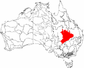
The Mulga Lands are an Interim Biogeographic Regionalisation for Australia (IBRA) region of eastern Australia consisting of dry sandy plains scattered with mulga trees.

Contents
Location and description
Located in inland New South Wales and Queensland these are flat plains with some low hills. and infertile sandy soil with a cover of grasses and shrubs with mulga and eucalyptus trees. The region contains areas of wetland, most of them only seasonally flooded, these include Lake Wyara and Lake Numalla, the Currawinya Lakes, Lake Bindegolly and others on the Warrego and the Paroo Rivers, the latter of which in particular remains relatively unmanaged and in its natural state.
The area has a very dry climate, with unpredictable low rainfall (450mm-650mm per year). The plains are drained in three directions: the eastern side by the Wallam, Nebine and Mungallala Creeks (tributaries of the Culgoa River), and the Warrego and Paroo rivers into the Murray-Darling basin; the southwest by the Bulloo River into wetlands near the Simpson Desert; and finally the northern side by the Barcoo River towards Lake Eyre. The Great Artesian Basin lies below these plains and more rich patches of wildlife are found around mound springs stemming from the basin.
The mulga lands are sparsely populated and mostly used for grazing sheep and cattle.
Ecology
The Mulga Lands are defined by their plant life and poor soil and as such are distinct from neighbouring ecoregions, the Brigalow Belt to the east and the Barkly Tableland to the north, both of which have better soil and richer plant life. To the south and east however the Mulga lands merge into the Simpson Desert.
Flora
Mulga trees are a type of acacia which have adapted to efficiently collect the sparse rainfall, are the distinctive habitat of this ecoregion while the ground cover consists of shrubs and grasses. However the mulga lands are not uniform and there are micro-climates and patches of other kinds of habitat, especially areas of eucalyptus woodland in the better-watered parts that have more wildlife than the mulga acacia plains themselves. Eucalyptus trees found here include bimble box, coolibah, and silver-leaved ironbark. To the east of the Warrego River in Queensland the mulga lands merge into a heath of sand dunes. Throughout the mulga lands plant life quickly flourishes after rainfall and habitats revive and change.
Fauna
Currawinya National Park is part of the project to revive Australia's population of the small bilby, bandicoot which in the park is protected from dingos and cats. This part of Australia is generally dry and when flooded Lakes Wyara and Numalla are important habitats for birds, being home to 250,000 birds of 40 species including the Rainbow Bee-eater, Australasian Shoveler duck, Freckled Duck (Stictonetta naevosa), Musk Duck (Biziura lobata), Black Swan (Cygnus atratus), Silver Gull (Larus novaehollandiae), Australian Pelican (Pelecanus conspicillatus), Great Egret (Egretta alba), and Glossy Ibis (Plegadis falcinellus).
Threats and preservation
80% of the original plant cover is intact especially in the drier inland west as some areas of eucalyptus woodland have been cleared in the eastern side of the area, and there are no endangered habitata in the mulga lands. However most of the area is used for grazing sheep and cattle so there is always a danger of overgrazing while mulga leaves are used as livestock fodder while other trees are removed to create more grassland and to allow access to water sources. The mound springs are particularly affected by this. There are some areas of National Park the largest of which is Currawinya, whose wetlands are especially important as bird habitats. Others include Hell Hole Gorge, Lake Bindegolly, Mariala, Thrushton, part of Welford, Idalia and the Culgoa Floodplain National Parks [1].
References
Coordinates: 28°05′51″S 145°40′52″E / 28.0975°S 145.68111°E
Categories:- Biogeography of Queensland
- IBRA regions
- Plains of Australia
- Temperate grasslands, savannas, and shrublands

Wikimedia Foundation. 2010.