- Mueang Samut Songkhram District
-
Mueang Samut Songkhram
เมืองสมุทรสงคราม— Amphoe — Amphoe location in Samut Songkhram Province
Coordinates: 13°24′50″N 100°0′12″E / 13.41389°N 100.00333°ECoordinates: 13°24′50″N 100°0′12″E / 13.41389°N 100.00333°E Country  Thailand
Province Samut Songkhram Seat Mae Klong Area - Total 169.057 km2 (65.3 sq mi) Population (2008) - Total 103,559 - Density 610.8/km2 (1,582/sq mi) Time zone THA (UTC+7) Postal code 75000 Geocode 7501 Mueang Samut Songkhram (Thai: เมืองสมุทรสงคราม) is the capital district (Amphoe Mueang) of Samut Songkhram Province, central Thailand.
Contents
History
The district was established in 1897, then named Lom Thuan and controlled by Monthon Ratchaburi. In 1900 the district office was moved to a temple area in Ban Prok. The district was named accordingly in 1917.[1] The office was moved again to Mae Klong camp, Tambon Mae Klong, and at the same time the name changed to Mae Klong in 1925.[2] By the government policy, the capital district name should be the same as the province name, Mae Klong district was renamed to Mueang Samut Songkhram in 1938.[3] Since 1964 the district office located on Ekachai road, Tambon Mae Klong.
Thai local people still call Mueang Samut Songkhram by its old name Mae Klong.
Geography
 Don Hoi Lot during high tide
The district is located at the shore of the Bay of Bangkok, at the mouth of the Mae Klong River.
Neighboring districts are (from the south clockwise) Ban Laem Phetchaburi Province, Amphawa and Bang Khonthi of Samut Songkhram, and Ban Phaeo and Mueang Samut Sakhon of Samut Sakhon Province.
Off the coast are the sandbanks of Don Hoi Lot famous for its endemic shell population of Solen regularis. The site is listed as a Ramsar wetland since 2001.
Administration
The district is subdivided into 11 subdistricts (Tambon), which are further subdivided into 85 villages (muban). Samut Songkhram itself has town status (thesaban mueang) and covers the whole tambon Mae Klong. There are further 10 Tambon administrative organizations (TAO).
No. Name Thai Villages Inh.[4] 1. Mae Klong แม่กลอง - 30,027 2. Bang Khan Taek บางขันแตก 12 8,944 3. Lat Yai ลาดใหญ่ 12 15,057 4. Ban Prok บ้านปรก 11 8,219 5. Bang Kaeo บางแก้ว 10 8,172 6. Thai Hat ท้ายหาด 6 4,775 7. Laem Yai แหลมใหญ่ 8 7,959 8. Khlong Khoen คลองเขิน 9 5,431 9. Khlong Khon คลองโคน 7 4,345 10. Nang Takhian นางตะเคียน 7 6,030 11. Bang Chakreng บางจะเกร็ง 5 4,600 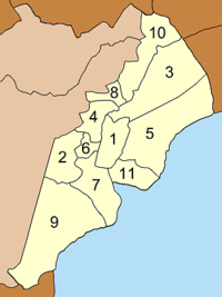
References
- ^ "ประกาศกระทรวงมหาดไทย เรื่อง เปลี่ยนชื่ออำเภอ" (in Thai) (PDF). Royal Gazette 34 (0 ก): 40–68. April 29 1917. http://www.ratchakitcha.soc.go.th/DATA/PDF/2460/A/40.PDF.
- ^ "ประกาศกระทรวงมหาดไทย เรื่อง เปลี่ยนแปลงอำเภอในจังหวัดสมุทรสงคราม" (in Thai). Royal Gazette 42 (0 ง): 24. 1925-04-05. http://www.ratchakitcha.soc.go.th/DATA/PDF/2468/D/24.PDF.
- ^ "พระราชกฤษฎีกาเปลี่ยนนามจังหวัด และอำเภอบางแห่ง พุทธศักราช ๒๔๘๑" (in Thai) (PDF). Royal Gazette 55 (0 ก): 658–666. November 14 1938. http://www.ratchakitcha.soc.go.th/DATA/PDF/2481/A/658.PDF.
- ^ "Population statistics 2008". Department of Provincial Administration. http://www.dopa.go.th/xstat/p5175_01.html.
External links
- amphoe.com (Thai)
Categories:- Amphoe of Samut Songkhram
- Central Thailand geography stubs


Wikimedia Foundation. 2010.