- Mt. Juliet, Tennessee
-
Mt. Juliet, Tennessee — City — 
SealMotto: The City Between the Lakes Location in Wilson County and the state of Tennessee
Coordinates: 36°12′10″N 86°30′49″W / 36.20278°N 86.51361°WCoordinates: 36°12′10″N 86°30′49″W / 36.20278°N 86.51361°W Country United States State Tennessee County Wilson Incorporated 1972 Government – Mayor Ed Hagerty Area – Total 16.6 sq mi (42.9 km2) – Land 16.2 sq mi (42 km2) – Water 0.3 sq mi (0.9 km2) Population (2008) – Total 25,234 – Density 760.9/sq mi (293.8/km2) Time zone CST (UTC-6) – Summer (DST) CDT (UTC-5) ZIP 37121 (P.O. boxes)
37122 (gen. delivery)
37138 (northwestern gen. delivery)Area code(s) 615 Website http://www.cityofmtjuliet.org/ Mt. Juliet is a city located in the western portion of Wilson County, Tennessee, U.S.A. It is a suburb of Nashville, and is approximately 17 miles (27 km) east of downtown. It is located roughly between two major national east-west routes, Interstate 40 and U.S. Route 70. As of the 2010 census, the city had a total population of 23,671, which represents a 91 percent increase over the 2000 Census. The city's official colors are the same as the town's high school: black and gold.
Contents
History
Mt. Juliet was formed in 1835 and became incorporated as a city in 1972. According to the Mt. Juliet Chamber of Commerce, the name of the town has two possible explanations. One theory is that the town was named for Julia Gleaves, a person who was renowned for taking care of those in need within the community. The most widely accepted story is that Mt. Juliet is named for a castle in County Kilkenny, Ireland.[1]
Geography
 Sign on Lebanon Road welcoming commuters to Mt. Juliet
Mt Juliet is located at 36°12'10" North, 86°30'49" West (36.202654, -86.513583)[2].
According to the United States Census Bureau, the city has a total area of 16.6 square miles (43 km2), of which, 16.2 square miles (42 km2) of it is land and 0.3 square miles (0.78 km2) of it is water. The total area is 1.99% water. Recent annexations along the east side of South Rutland Road as well as a land swap with the City of Lebanon for the Bel Air at Beckwith project (southeast quadrant of I-40/Beckwith Road interchange) have increased the city's geographical area to approximately 21.78 square miles (56.4 km2).
Mt Juliet's official city slogan is "The City Between The Lakes", reflecting the city's proximity to Old Hickory Lake (Cumberland River) to its north and Percy Priest Lake (Stones River) to its south, both of which are man-made reservoirs.
Demographics
 Dating back to the mid 1800's Cook's United Methodist Church is one of the oldest churches in Mt. Juliet
As of the census[3] of 2000, there were 12,366 people, 4,341 households, and 3,576 families residing in the city. The population density was 761.2 people per square mile (293.8/km²). There were 4,673 housing units at an average density of 287.6 per square mile (111.0/km²). The racial makeup of the city was 93.86% Caucasian, 3.93% African American, 0.39% Native American, 0.52% Asian, 0.01% Pacific Islander, 0.29% from other races, and 1.00% from two or more races. 1.17% of the population were Hispanic or Latino of any race.
There were 4,341 households out of which 46.0% had children under the age of 18 living with them, 67.3% were married couples living together, 11.2% had a female householder with no husband present, and 17.6% were non-families. Thirteen-point-eight percent of all households were made up of individuals and 3.3% had someone living alone who was 65 years of age or older. The average household size was 2.82 and the average family size was 3.12.
In the city the population was spread out with 30.5% under the age of 18, 6.5% from 18 to 24, 35.3% from 25 to 44, 21.4% from 45 to 64, and 6.3% who were 65 years of age or older. The median age was 34 years. For every 100 females there were 95.4 males. For every 100 females age 18 and over, there were 93.4 males.
The median income for a household in the city was $58,600, and the median income for a family was $63,065. Males had a median income of $43,732 versus $28,515 for females. The per capita income for the city was $22,567. Two-point-four percent of the population and one-point-seven percent of families were below the poverty line. 3.2% of those under the age of 18 and 4.0% of those 65 and older were living below the poverty line.
Mt. Juliet has claimed to be the "fastest-growing city in Tennessee", and it does qualify for this distinction if one considers growth from 1980–2000 for Tennessee cities with a population over 10,000. In recent years, LaVergne in Rutherford County and Spring Hill in Williamson County have grown by a larger percentage basis. Mt. Juliet remains one of the fastest growing places in Tennessee.
 Mt. Juliet City Hall
Government/Politics
Mt. Juliet was incorporated in 1972 and operates on a "City Manager" system. The city has five elected leaders: four commissioners (one from each of the city's four districts) and a mayor, elected at-large, who serves as chairperson of the City Commission. Elected officials, including the mayor, are not employed full-time by the city. The Commission selects and appoints a City Manager, who is employed full-time and runs the city's business on a day-to-day basis. All elected city officials serve 4-year terms.
Politically, Mt. Juliet leans heavily conservative. Party politics play no role in city elections because of the large Republican presence. City growth tends to be the central issue in every race. Mt. Juliet currently serves as the anchor city for Tennessee House of Representatives District 57 (occupied by former Mt. Juliet Mayor Linda Elam, Republican) and Tennessee Senate District 17 (occupied by Mae Beavers, a former house member and third-term senate Republican). In 2002, after many years in Tennessee's 6th Congressional District, Mt. Juliet was redistricted into the 5th Congressional District, which derives the bulk of its constituency from Democratic-leaning Nashville-Davidson County. That seat is currently held by Jim Cooper, a fifth-term Democrat from Nashville, who has a branch office in Mt. Juliet.
Mt. Juliet currently has no city property tax, though Wilson County does impose a property tax on property owners.
Education
 The current Mt. Juliet High School.
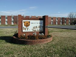 The former Mt. Juliet High School. MJHS moved to a new building in August 2008. This building now houses Mt. Juliet Middle School.
Mt. Juliet does not have a city school system. All schools are operated by the Wilson County School District.
Mt. Juliet High School (Golden Bears), is located just outside the city limits, although many students residing within the city are also zoned to Wilson Central High School (Wildcats), located in nearby Lebanon. Mt. Juliet High School moved into a brand new building which opened August 11, 2008 for the 2008-2009 school year. The old Mt. Juliet High School became Mt. Juliet Middle School and the old Mt. Juliet Middle School became Elzie D. Patton Elementary.
Two middle schools are located within the city limits:
- Mt. Juliet Middle (feeds to MJHS) (Golden Bears)
- West Wilson Middle (feeds to either WCHS or MJHS)(Wildcats as of 07-08, previously known as the Wolves)
Mt. Juliet students are zoned to several elementary schools:
Feeding to Mt. Juliet Middle School, and ultimately Mt. Juliet High School
- Mt. Juliet Elementary (Bears)
- W.A. Wright Elementary (Knights)
- Lakeview Elementary (Golden Eagles)
- Elzie D. Patton Elementary (Patriots)
Feeding to West Wilson Middle School, and ultimately Wilson Central High School
- Stoner Creek Elementary (Bobcats)
- West Elementary (Bulldogs)
- Rutland Elementary (Rockets)
- Gladeville Elementary (Gators)
Future Wilson County Schools in Mt. Juliet, Tennessee.
- Rutland Elementary PK-2
- Rutland Elementary 3-5 (Old Rutland PK-5 School)
- Rutland/Gladeville Middle (6th-8th)
The following three schools will make up the North Central Campus.
- North Central Elementary (PK-5)
- North Central Middle (6-8)
- North Central High (9-12)
More information can be found on the capital outlay plan on the Wilson County Schools website (www.wcschools.com)
The city is home to one K-12 private school, Mount Juliet Christian Academy (Saints), located within First Baptist Church, although dozens of other private schools are located within a 30 minute drive, including Friendship Christian School (Commanders) in Lebanon, as well as Donelson Christian Academy (Wildcats) in Donelson. Other prep schools not affiliated with religious organizations can be found in Nashville. There are four "tutorial programs" which meet weekly in Mt. Juliet for home-schooled high school students. Wilson County's only Montessori School, Mt Juliet Montessori Academy, opened in Fall 2007.
Cumberland University has a satellite campus in Mt. Juliet. The nearest community college, Volunteer State Community College, is 20 miles (32 km) north in Gallatin. The nearest public college/university is Tennessee State University, located 20 miles (32 km) west in Nashville. The nearest private college/university is Cumberland University, 14 miles (23 km) east in Lebanon. Several other public and private colleges and universities are nearby in Nashville and Murfreesboro.
Transportation
Interstate 40 and U.S. Route 70 (Lebanon Road) run east/west through Mt. Juliet, and State Route 171 (Mt Juliet Road) runs north-to-south connecting US-70 to I-40, before continuing toward Interstate 24 in the Antioch area.
Mt. Juliet serves as a stop on the Music City Star commuter rail service into Nashville, operating over freight carrier Nashville and Eastern Railroad.
For commercial air traffic, Mt. Juliet is served by Nashville International Airport, located 9 miles (14 km) west of the city via Interstate 40.
Entertainment/Shopping
 Providence Market Place is Mt. Juliet's largest shopping center
A new, large-scale commercial and residential development called "Providence Marketplace" is located on the city's southern side near Interstate 40. Tenants include Target, Belk, JCPenney, Best Buy, PetSmart, Old Navy, Kroger, and a 14-screen multiplex operated by Regal Entertainment. Other major retailers can be found in the Paddocks development, north of Interstate 40.
In 1999, citizens voted to allow Liquor-By-The-Drink sales inside the city limits, in the hope of attracting major chain restaurants. Without this regulation in place, it is likely that Providence Marketplace would have never been developed.[citation needed]
Nashville Superspeedway, a 1.33-mile (2.14 km) oval hosting NASCAR Busch Series, Craftsman Truck Series, and Indy Racing League events, is located in nearby Gladeville.
Recreation
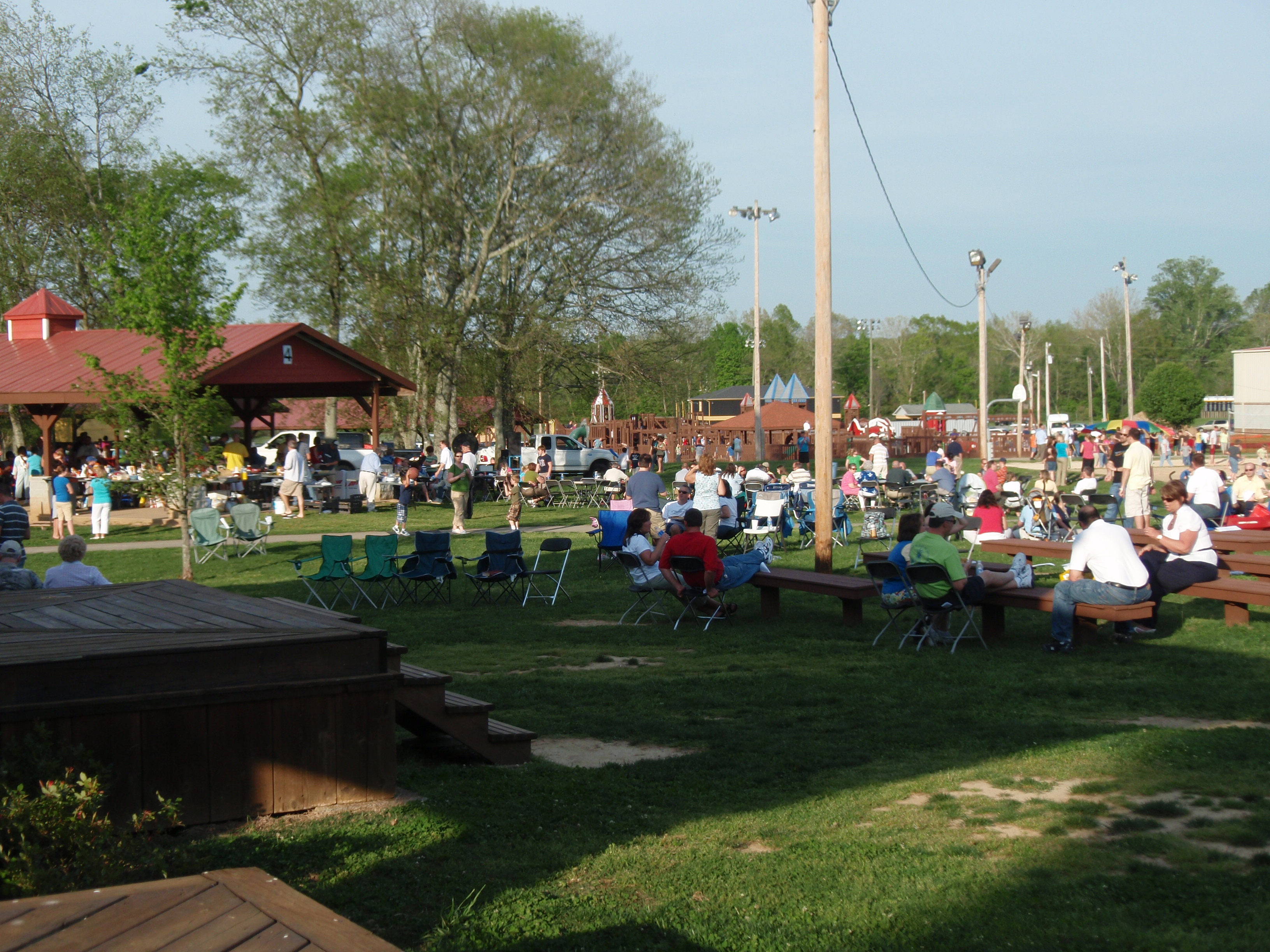
 Charlie Daniels Park in Mount Juliet
Mt. Juliet has three public parks:
- Charlie Daniels Park (named in honor of the musician who makes his home in Mt. Juliet) is home to tennis courts, a large children's playground, the city's youth football fields, and the Mt. Juliet Community Center (a public meeting place and gymnasium). The city also recently[when?] constructed a bandshell at the park for the purpose of hosting musical festivals.
- Sgt. Jerry Mundy Memorial Park (named in honor of a city police officer killed in the line of duty on July 9, 2003) features four softball fields, a soccer field, a frisbee golf course, and a smaller playground. Prior to 2003, this park was called "Millennium Sportsplex."
- South Mt. Juliet City Park has a pavilion, sand volleyball court, children's play area, and nature trail in addition to Mt. Juliet's very own "Bark Park," a 3/4 acre fenced-in area allowing people and their dog playspace.
Three state parks are located within a 30-minute drive of the city:
- Long Hunter State Park, 7 miles (11 km) to the south
- Bicentennial Mall State Park, app. 18 miles (29 km) to the west in downtown Nashville
- Cedars of Lebanon State Park, app. 20 miles (32 km) to the southeast
Mt. Juliet is also home to one of the largest Little League baseball organizations in the state.[citation needed] The privately owned little league park features more than a dozen baseball and softball fields.
Fishing and boating are popular pastimes in Mt. Juliet, resultant of the city's proximity to Percy Priest and Old Hickory lakes.
Swimming is an up and coming sport in Mt Juliet and West Wilson County. Two Summer League Teams exist, one at Langford Farms and the other at Willoughby Station.
City Services
The City of Mt. Juliet operates a police department. Fire and ambulance service are provided by WEMA (the Wilson Emergency Management Agency - operated by county government). There is one fire/ambulance station within the city limits, with three other nearby stations serving city residents. Mt Juliet has two police stations: the main office at City Hall in the center of town, the other (a much smaller branch office) near W.A. Wright Elementary School on the city's northwest side. In December 2008, the Mt. Juliet Police Department Animal Control Division opened a shelter on Industrial Drive.
Media/Communications
Mt. Juliet High School hosts a student-run news program called BNN (Bear News Network) on Channel 9 each school day for a short period with club meetings and announcements and the station runs the rest of the time with school and community information in the form of a slide presentation. The audio on Channel 9 is provided by WPLN-FM, Nashville's NPR affiliate.
Mt. Juliet is currently served by two weekly newspapers, The Mt. Juliet News (50¢) and The Chronicle of Mt. Juliet (free), both published on Wednesdays. Mt. Juliet also falls within the circulation areas of daily newspapers The (Nashville) Tennessean and The Lebanon Democrat.
See also
Mt Juliet (Music City Star station)
External links
References
- ^ Mt. Juliet West Wilson Chamber of Commerce - Community Information
- ^ "US Gazetteer files: 2010, 2000, and 1990". United States Census Bureau. 2011-02-12. http://www.census.gov/geo/www/gazetteer/gazette.html. Retrieved 2011-04-23.
- ^ "American FactFinder". United States Census Bureau. http://factfinder.census.gov. Retrieved 2008-01-31.
Municipalities and communities of Wilson County, Tennessee Towns 
CDPs Unincorporated
communitiesBelinda City | Gladeville | LaGuardo | Norene | Statesville | Suggs Creek | Tuckers Crossroads
Categories:- Cities in Tennessee
- Populated places in Wilson County, Tennessee
- Nashville metropolitan area
- Populated places established in 1835


Wikimedia Foundation. 2010.