- Mount Druitt railway station
-
 Mount Druitt
Blue Mountains Line Western Line Station code MTT Suburb Mount Druitt Street(s) North Parade Distance from Central Station 43.29 km Altitude (above sea level) ? m Types of stopping trains Suburban all stops
Suburban limited stopsNumber of platforms 4 Number of tracks 4 Platform arrangement 2 Island Type of station Ground Ticket barriers Yes Transfers available Bus Disabled access 
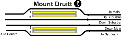
Yes Station facilities Link Mount Druitt is a railway station on the Western line, Sydney of the CityRail network. It serves a well established residential, educational and commercial area. It has four tracks, paired by direction. This means that all trains to the city leave from the same island platform, so if the train happens to travel on the unexpected track, it is a simple thing to walk over to the other platform. Mount Druitt's platforms are accessible by lifts, and is therefore classified as an Easy Access station for wheelchairs. The station is also a bus interchange for Westbus and Busways private bus operators providing bus services to the local Mount Druitt area and connecting passengers to the outer suburbs (St Marys, Minchinbury, Willmot, Dean Park, Doonside and Blacktown).
Contents
History
The first railway station in Mount Druitt was opened on 19 August 1881. It was replaced by a station which was erected in 1946 near Belmore Avenue (a pedestrian bridge marks the location of the railway crossing and station). The existing station (adjacent to Westfield was opened on 8 December 1974. Electric services commenced on 8 October 1955, with an opening ceremony conducted by the then Premier of New South Wales Joseph Cahill.
Platforms and services
The station is served by two trains per hour each way, with additional trains during weekday peak hours.
Platform Line Stopping Pattern Notes 
Western Line All stations and limited stops services to Central, then on to the ■North Shore Line. 
Western Line All stations and limited stops services to Central, then on to the ■North Shore Line. Mainly used during weekday peak hours Blue Mountains Line Intercity services to Sydney Terminal.[1] Morning and late night services Only. 
Western Line All stations services to St Marys, Penrith and Emu Plains; peak hour limited stops services to St Marys, Penrith and Emu Plains. Mainly used during weekday peak hours Blue Mountains Line Intercity services to Springwood and Lithgow via Katoomba.[1] Early morning and evening services Only. 
Western Line All stations services to St Marys, Penrith and Emu Plains; peak hour limited stops services to St Marys, Penrith and Emu Plains. Bus services
 Interchange bus bay
 Stairs leading up to footbridge over to station from interchange
 Footbridge connecting station and interchange over road
Mount Druitt Station Bus Interchange
Stand 1: Busways
- 756 - to Blacktown via Powers Road and Doonside
- 757 - to Marsden Park and Riverstone
Stand 2: Busways
- 755 - to Shalvey and Plumpton (OFF PEAK)
- 758 - to St Marys via Shalvey and North St Marys
Stand 3: Busways
- 754 - to Blacktown via Hassall Grove
Stand 4: Busways
- 761 - to Bidwill via Carlisle Avenue
- 750 - to Blacktown via Carlisle Avenue and Richmond Road
Stand 5: Busways
- 737 - to Eastern Creek
- 738 - to Eastern Creek Industrial Park and Horsley Park
- 739 - to Minchinbury
Westbus
- 674 - to Windsor via Whalan, Tregear, Shanes Park, Berkshire Park and South Windsor
- 759 - to St Marys via Emerton, Lethbridge Park, Tregear, Willmot, Ropes Crossing and North St Marys
- 780 - to Penrith, New South Wales via Whalan, Tregear, Ropes Crossing, Werrington County and Cambridge Park
- 770 - to Penrith via Colyton, St Marys, Claremont Meadows and Kingswood
- 771 - to St Marys via Colyton.
- 774 - to Penrith via Oxley Park, St Marys, UWS Kingswood and Nepean Hospital
- 775 - to Penrith via Erskine Park, St Clair, St Marys, UWS Kingswood and Nepean Hospital
- 776 - to Penrith via St Clair, St Marys, UWS Kingswood and Nepean Hospital
NightRide
- N70 - between Penrith station and Town Hall
Image Gallery
-

Platform 1
-

Platform 2
-

Platform 3
-

Platform 4
-

Ramps leading up to concourse from platforms
-

Ticket barriers and manual indicators
-

North end of platforms
-

Platforms 2 and 3 looking north from footbridge
-

Interchange seen from footbridge
-

Interchange bay
Trackplan
Neighbouring stations
Preceding station CityRail Following station towards Emu PlainsWestern Line Rooty Hilltowards Centraltowards LithgowBlue Mountains Line Blacktowntowards CentralExternal links
- Blacktown City Council - Photo of the original railway station
- Blacktown City Council - Photo of the ceremony at commencement of electric services
- NSWrail.net - Mount Druitt Railway Station
Western Line - Central
- Redfern
- Burwood
- Strathfield
- Lidcombe
- Auburn
- Clyde
- Granville
- Harris Park
- Parramatta
- Westmead
- Wentworthville
- Pendle Hill
- Toongabbie
- Seven Hills
- Blacktown
- Doonside
- Rooty Hill
- Mount Druitt
- St Marys
- Werrington
- Kingswood
- Penrith
- Emu Plains
- Marayong
- Quakers Hill
- Schofields
- Riverstone
- Vineyard
- Mulgrave
- Windsor
- Clarendon
- East Richmond
- Richmond
(stations in italics are under planning or under construction)CityRail LinesSuburban - Eastern Suburbs & Illawarra
- Bankstown
- Inner West
- Airport & East Hills
- South
- Cumberland
- Western
- North Shore
- Carlingford
- Olympic Park
- Northern
Interurban and regional - South Coast
- Southern Highlands
- Blue Mountains
- Newcastle & Central Coast
- Hunter
Under construction or planning: South West Rail Link, North West Rail LinkCoordinates: 33°46′11″S 150°49′11″E / 33.76961389°S 150.8197972°E
References
Categories:- Railway stations in Sydney
- Railway stations opened in 1915


Wikimedia Foundation. 2010.