- Monteceneri
-
This article is about the municipality. For the mountain pass, see Monte Ceneri Pass. For the transmitter, see Monte Ceneri transmitter.
Monteceneri 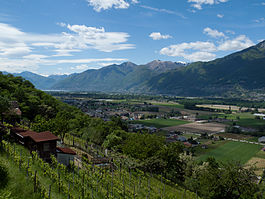
Country Switzerland Canton Ticino District Lugano Coordinates 46°7′N 08°56′E / 46.117°N 8.933°ECoordinates: 46°7′N 08°56′E / 46.117°N 8.933°E Population 3,899 (Dec 2009)[1] - Density 105 /km2 (273 /sq mi) Area 37.04 km2 (14.30 sq mi) Elevation 196 m (643 ft) Postal code 6573 SFOS number 5238 Mayor Tiziano Ponti Localities Medeglia, Bironico, Camignolo, Rivera and Sigirino Website Monteceneri.ch
Profile (Italian), SFSO statistics
 Monteceneri
View map of Monteceneri Monteceneri is a municipality in the district of Lugano in the canton of Ticino in Switzerland. It was created on 21 November 2010 through the merger of the municipalities of Medeglia, Bironico, Camignolo, Rivera and Sigirino.
Contents
History
Medeglia is first mentioned in 1195 as Medellia.[2] Bironico is first mentioned in 1296 as Bironico.[3] Camignolo is first mentioned in 1296 as Camigiollo.[4] Rivera is first mentioned in 1296 as Sorenzino. In 1348 it was mentioned as Rivera.[5] Sigirino is first mentioned in 1335 as Sezelino.[6]
Medeglia
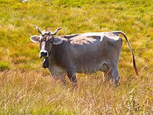 A cow in an alpine pasture near Medeglia
It can be assumed that in the High Middle Ages, Medeglia was part of the old valley community of Carvina. In 1501-03 changed area around Isone, Medeglia and Lugano became part of the county of Bellinzona, but remained in the Agno parish. It became part of the parish of Bironico in the 13th Century. Then, in 1585, it broke away from that parish to become a vice parish. It was raised to a full parish in 1888. The parish church of St. Bartholomew was first mentioned in 1328. The romanesque core of the church was renovated and rebuilt in the 15th and 17 Centuries.[2]
The local economy of the village was based on animal husbandry and forestry. Starting in the 16th Century the residents of Isone and Medeglia bought forests and pastures as far away as Robasacco, Contone, Cadenazzo, Sant'Antonino and Camorino while at the same time opening up trade relations with Bellinzona. In the 19th Century, many inhabitants emigrated with the majority going to Argentina and California. The mountain pastures of Medeglia were classified in 1996 as a wetland of national importance. In 2000, three quarters of the working population worked outside the municipality.[2]
Bironico
By 1000, Bironico was probably the secular and religious center of Carvina, which included the middle and upper Vedeggio valley. For example, former parish included the villages of Camignolo, Ison, Medeglia, Mezzovico-Vira, Rivera, Robasacco and Sigirino. In the Early Middle Ages it was under the authority of the bishop of Como, followed by the city of Como. At the end of the 13th Century, the Rusca, a noble family from Como, lived in the community. They lived in the castle between 1328-1416. Starting in the 16th Century, an inn at the bridge over the Leguana served as a meeting place of the Swiss Confederation's ministers.[3]
The parish church is from 1267 and is dedicated to St. Martin.[3]
In the past, the local economy relied on traditional alpine agriculture and emigration. Trade and industry have recently increased, but the current economic structure is dominated by commuters to the lower Vedeggio valley, Lugano and Bellinzona.[3]
Camignolo
In the Middle Ages Camignolo appears as part of the parish of Bironico and valley community of Valle Carvina. Como Cathedral had properties in the village. San Ambrogio castle is mentioned in 1348. It was probably destroyed around the beginning of Swiss Confederation rule in the 16th Century.
It was a vice-parish in 1670, and became a full parish in 1809. The parish church of S. Pietro e Paolo is first mentioned in the 15th Century. Its present form comes from a reconstruction in 1670. The 10th Century chapel of S. Ambrogio (first mentioned in 1348) is rich in frescoes from the late Romanesque and the 15th Century. It was restored in 1976-79.[4]
The inhabitants are still mainly employed in agriculture, though there was constant, large-scale emigration before the industrialization of the valley. Only in recent decades, has there been was a modest development in construction, industry and trade. Camignolo is the seat of a secondary school.[4]
Rivera
Archeological objects and graves from the Iron Age and the Roman era have been found in Rivera. In the Middle Ages, Rivera was part of the valley community of Carvina. In the 13th Century Como Cathedral possessed estates in Sorencino. Starting in 1678, representatives from the twelve members of the Swiss Confederation in Ticino met in Casa dei landfogti before they assembled in Lugano.[5]
Rivera was a member of the parish of Bironico, before it became an independent parish in 1754. From 1779 until 1793, the parish church of S. Spirito was rebuilt.[5]
The villagers earned their living from agriculture, mostly in alpine meadows and pastures. During construction of the Ceneri tunnel in 1872-82, the population increased sharply. The completion of the road in 1811 and the construction of the tunnel and the station led to the emergence of a new district in the flatter part of the valley. This area forms the northern boundary of the agglomeration of Lugano. The base station of the Monte Tamaro gondola opened in 1972 in Rivera.[5]
Sigirino
In the Middle Ages, Sigirino belonged to the territory of the Carvina valley community. In a land register of 1296,Como Cathedral possessed lands, pastures, forests, farmland and land with houses in Sigirino. It is likely that at that time Sigirino possessed some type of fortifications.[6]
The Church of St. Andrew was first mentioned in 1296. It was totally rebuilt in the 16th Century and restored in the 18th. After its separation from Bironico in 1625, Sigirino had its own parish.[6]
Economically, the village was dominated by agriculture and emigration. In the 21st Century, it belongs to commercial and industrial zone in the valley floor between Sigirino and the neighboring villages.[6]
Geography
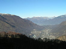 View down Monte Ceneri pass
Monteceneri has an area, as of 1997[update], of 37.04 square kilometers (14.30 sq mi). Of this area, 2.65 km2 (1.02 sq mi) or 7.2% is used for agricultural purposes, while 28.51 km2 (11.01 sq mi) or 77.0% is forested. Of the rest of the land, 2.79 km2 (1.08 sq mi) or 7.5% is settled (buildings or roads), 0.27 km2 (0.10 sq mi) or 0.7% is either rivers or lakes and 2.11 km2 (0.81 sq mi) or 5.7% is unproductive land.
Of the built up area, housing and buildings made up 3.0% and transportation infrastructure made up 3.0%. Out of the forested land, 66.8% of the total land area is heavily forested and 2.7% is covered with orchards or small clusters of trees. Of the agricultural land, 3.4% is used for growing crops and 3.0% is used for alpine pastures. All the water in the municipality is flowing water. Of the unproductive areas, 4.9% is unproductive vegetation.[7]
Demographics
Monteceneri has a population (as of December 2009[update]) of 3,899.[1]
Historic Population
The historical population is given in the following chart:[2][3][4][5][6][8]

Heritage sites of national significance
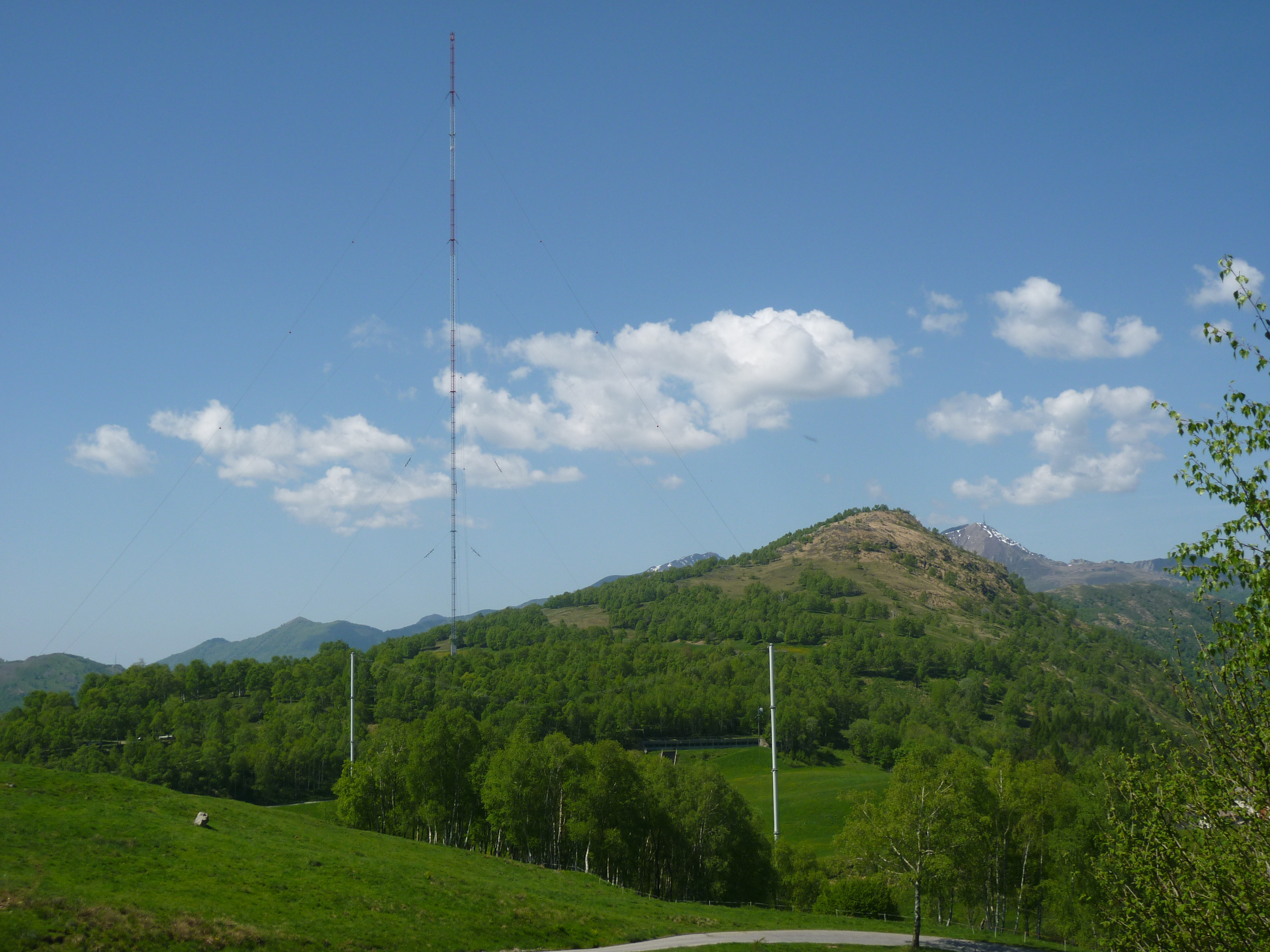
 Radio tower on Monte Ceneri
The Ruderi Del Castello Di S. Sofia and Stazione Radio Monte Ceneri are listed as Swiss heritage site of national significance. The entire villaggio of Osignano is designated as part of the Inventory of Swiss Heritage Sites.[9]
References
- ^ a b Swiss Federal Statistical Office, MS Excel document – Bilanz der ständigen Wohnbevölkerung nach Kantonen, Bezirken und Gemeinden (German) accessed 25 August 2010
- ^ a b c d Medeglia in German, French and Italian in the online Historical Dictionary of Switzerland.
- ^ a b c d e Bironico in German, French and Italian in the online Historical Dictionary of Switzerland.
- ^ a b c d Camignolo in German, French and Italian in the online Historical Dictionary of Switzerland.
- ^ a b c d e Rivera in German, French and Italian in the online Historical Dictionary of Switzerland.
- ^ a b c d e Sigirino in German, French and Italian in the online Historical Dictionary of Switzerland.
- ^ Altitudine, superficie, secondo il genere di utilizzazione, rilevazione 1992/1997, e densità della popolazione, nel 2000 (Italian) accessed 25 October 2010
- ^ Popolazione residente, dal 1850 (Italian) accessed 23 November 2010
- ^ "Kantonsliste A-Objekte:Ticino" (in German). KGS Inventar. Federal Office of Civil Protection. 2009. http://www.bevoelkerungsschutz.admin.ch/internet/bs/de/home/themen/kgs/kgs_inventar/a-objekte.parsys.000117.DownloadFile.tmp/ti.pdf. Retrieved 12 July 2010.
Agno | Alto Malcantone | Aranno | Arogno | Astano | Bedano | Bedigliora | Bioggio | Bissone | Bogno | Brusino Arsizio | Cademario | Cadempino | Cadro | Canobbio | Capriasca | Carabietta | Carona | Caslano | Certara | Cimadera | Collina d'Oro | Comano | Croglio | Cureglia | Curio | Grancia | Gravesano | Lamone | Lugano | Magliaso | Manno | Maroggia | Massagno | Melano | Melide | Mezzovico-Vira | Miglieglia | Monteceneri | Monteggio | Morcote | Muzzano | Neggio | Novaggio | Origlio | Paradiso | Ponte Capriasca | Ponte Tresa | Porza | Pura | Rovio | Savosa | Sessa | Sonvico | Sorengo | Torricella-Taverne | Valcolla | Vernate | Vezia | Vico Morcote
Ticino | Districts of Canton Ticino | Municipalities of the canton of Ticino Categories:
- Municipalities of Ticino
- Municipalities of Switzerland
- Cultural property of national significance in the canton of Ticino


Wikimedia Foundation. 2010.