- Moel y Gaer, Rhosesmor
-
For other places with the same name, see Moel y Gaer.
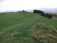 Remains of the rampart of Moel y Gaer
Moel y Gaer (Welsh for "bald hill of the fortress") is a prehistoric hill fort located on a summit of Halkyn Mountain, overlooking the village of Rhosesmor, Flintshire, Wales.
Excavations suggest that the site was occupied, perhaps sporadically, from the Neolithic period to sometime before the Roman conquest of the area. Remains of a timber long house on the hill summit have been dated to the third millennium BC and may represent the earliest human occupation of the region.[1] Defensive construction at the site began around the late seventh century BC, and at first consisted of a timber palisade enclosing a settlement of timber roundhouses. The palisade was later replaced by a stone-and-earth rampart and a ditch.[2]
Much of the archaeological work at Moel y Gaer was carried out in the early 1970s, before the construction of a reservoir on the hilltop in 1979 destroyed a portion of the remains.[3]
See also
References
- ^ "Settlement Landscapes". Historic Landscape Characterisation: Holywell Common and Halkyn Mountain. Clwyd-Powys Archaeological Trust. http://www.cpat.org.uk/projects/longer/histland/holywell/hosettle.htm. Retrieved 26 September 2009.
- ^ "Defensive and Military Landscapes". Historic Landscape Characterisation: Holywell Common and Halkyn Mountain. Clwyd-Powys Archaeological Trust. http://www.cpat.org.uk/projects/longer/histland/holywell/hodefend.htm. Retrieved 26 September 2009.
- ^ Darvill, Timothy (1996). Prehistoric Britain from the Air: A Study of Space, Time and Society. Cambridge: Cambridge UP. p. 110. ISBN 0-521-55132-3. http://books.google.com/books?id=ZPC_Bd7reVcC&pg=PA110. Retrieved 2 December 2010.
External links
- Moel y Gaer, Rhosesmor at the BBC Web site
- Reconstruction of Moel y Gaer settlement at Gathering the Jewels
Coordinates: 53°12′45″N 3°10′58″W / 53.2126°N 3.1827°W
Categories:- Hill forts in Wales
- Archaeological sites in Flintshire
- Clwyd geography stubs


Wikimedia Foundation. 2010.