- Rome Metro
-
Metropolitana di Roma 

Info Locale Rome Transit type Rapid transit Number of lines 2 Number of stations 49 Operation Began operation 1955 Operator(s) ATAC Technical Track gauge 1,435 mm (4 ft 8 1⁄2 in) (standard gauge) Electrification Overhead lines System map 
The Rome Metro (Italian: Metropolitana di Roma) is an underground public transportation system that operates in Rome, Italy and opened in 1955. There are currently two metro lines, the A line (identified by the orange colour) and the B line (blue). A third line, the green C line, and a new branch of the B line, are currently under construction. Plans have also been revealed for a fourth line, to be called the D Line. The current network 38 km (24 mi) has an X-shape with the lines intersecting at Termini Station, the main train station in Rome.
Rome's local transport provider, ATAC, also operates several other rail services: the Roma-Lido line, the Roma-Giardinetti line, and the Roma-Nord line. The first of these, the Rome-Lido railway line, which connects Rome to the sea at Ostia, is effectively part of the metro network. It is run along similar lines to the metro and uses trains similar to those in service on the A and B lines. The Roma-Giardinetti line, although officially designated as a railway, is a narrow gauge tram line, while the Roma-Nord line is a suburban railway.
Contents
Lines
Line A
 Main article: Line A (Rome Metro)
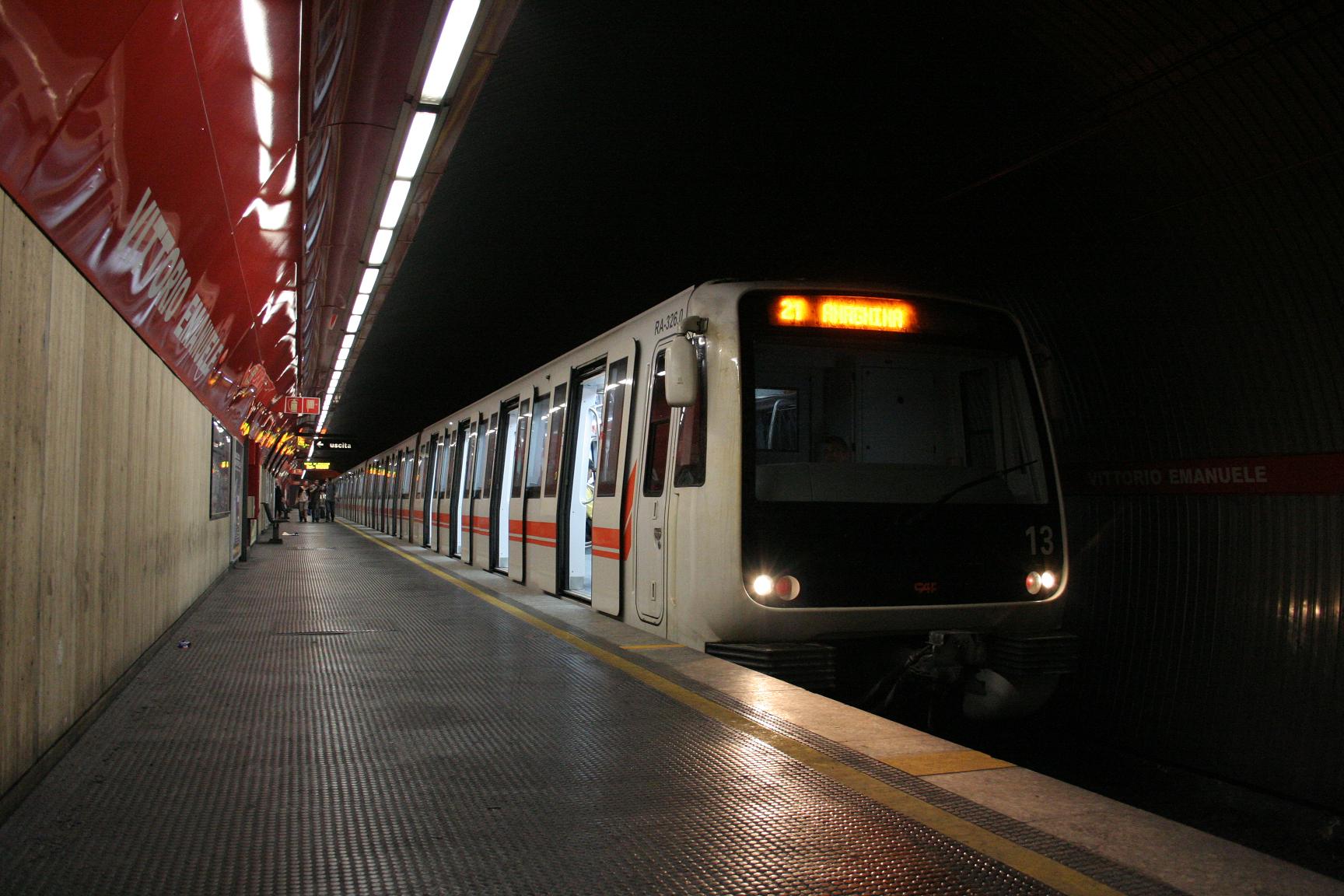
The A line connects the north-west of the city with the south-east. It currently has 27 stations with terminals at Battistini and Anagnina. Its distinguished by the colour orange.
Approval was given for the construction of the Rome's second metro line in 1959. Subsequently called the A line it would run roughly perpendicularly to the existing metro line, now called the B line.
Works on the A line began in 1964 in the Tuscolana area but were subject to a series of delays caused by poor organisation. Above all, the originally planned method of construction of cut and cover posed serious problems for road traffic in south-east Rome. Work on the metro was suspended and began again 5 years later, using bored tunnels which partially resolved the traffic problems but caused numerous claims for compensation arising for vibrations caused by the machine. Work was also frequently interrupted by archaeological finds made during the excavations, particularly near Piazza della Repubblica.
The A line finally entered into service in February 1980. In the late 1990s it was extended from Ottaviano in Prati to Battistini to the west.
Line B
 Main article: Line B (Rome Metro)
Notwithstanding its name, the B line was in fact the first metro line in Rome. The line B connects the north-east of the city with the south-west. It currently has 22 stations with terminals at Rebibbia and Laurentina (just east of EUR). It's distinguished by the colour blue.
The B line was planned during the 1930s by the Fascist government in search of a rapid connection between the main train station, Termini, and a new district to the south-east of the city, E42, the planned location of the Universal Exposition (or Expo), which was to be held in Rome in 1942. The exposition never took place due to Italy's entrance into the Second World War in 1940. When works were interrupted, some of the tunnels on the city-centre side of the metro (between Termini and Piramide) had been completed, and they were used as air raid shelters during the war.
Work on the metro began again in 1948, in concert with works on turning the space, formerly designated for the Expo, into a commercial district under the name EUR. The metro was officially opened on 9 February 1955 by the then President of the Republic Luigi Einaudi. Regular services began the following day.
In 1990 the B line was extended from Termini to Rebibbia to the east of the city and the entire line was modernised.
Other rail lines operated by the metro company
Roma-Lido
See also: Rome-Lido railway line
Construction of the Roma-Lido line began shortly after the end of the first world war and was completed some six years later in 1924. It began operation as a steam locomotion railway but electrification was completed less than a year later.
The line currently is operated an integrated part of the metro system, but is entirely overland. It runs from the Roma Porta San Paolo station beside the Pyramide metro B line station and runs alongside the B line as far as EUR Magliana. It then continues separately on to the seaside town of Ostia. The line terminates beside the end of Via Cristoforo Colombo.
Roma-Giardinetti

 A train of the Roma-Giardinetti line
Officially termed a railway, the Roma-Giardinetti line is a narrow gauge tram which connects Laziali (a regional train station some 800 metres from Temini's main concourse) with Giardinetti to the east just past the Grande Raccordo Anulare (GRA), Rome's orbital motorway. The line originally ran to Frosinone some 137 km from Rome, but has been gradually reduced in length, most recently when the section from Giardinetti to Pantano, which will become a permanent part of the new C line metro, was taken out of service.
Roma-Civitacastellana-Viterbo

 Montebello station
The Roma-Civitacastellana-Viterbo line (also called Roma Nord railway) began life as narrow gauge tram running from Piazza della Libertà in Rome to Civita Castellana. However the next stretch of the line, to Viterbo, was built as a railway and over the years the tram section was converted into a railway as well. A process which concluded with the moving of the Roman terminus from the street-level terminus at Piazza della Libertà across the river to a new underground station in Piazzale Flaminio, beside the subsequently constructed metro A line station, after the Second World War.
The line is currently operated in two modes: as an urban service from Piazzale Flaminio to Montebello[disambiguation needed
 ], and as an suburban service from Piazzale Flaminio to Viterbo. The urban service operates with a frequency of about one train every 10 minutes, while the suburban service operates considerably less frequently, with less than a third of the trains making the full two and a half hour journey from Rome to Viterbo.
Other rail lines operated by Trenitalia
 Balduina stationMain article: Ferrovie regionali del Lazio
The system of the Ferrovie Regionali del Lazio (Lazio regional railways) consists of 8 lines, operated by Trenitalia, converging on the city of Rome. The lines FR1, FR2, and FR3 facilities, particularly in urban routes to Rome, a rapid transit service, integrated with the underground and surface vessels.
Future expansions
Line C
 Main article: Line C (Rome Metro)
Currently under construction, the C line is intended to run from Grottarossa, north of the Vatican, to Pantano, previously the terminus of the Roma-Giardinetti tram line. The C line will be the first metro line to extend beyond the city limits. Line C will intersect with Line A at Ottaviano (beside the Vatican) and at San Giovanni, and with the Line B at the Colosseum. It will also intersect with the planned Line D at Piazza Venezia, creating a second metro hub in Rome.
 Overview map of Rome Underground and Rail in 2015
Phase one of the C line is the furthest from the centre and is due to open in 2011 with 15 stations out of the planned 30 in service from Centocelle to Pantano. Phase two will extend the line to Piazza Lodi with a further 6 stations in service and is planned to open in 2012. The third and final phase, which will complete the line, is due to open in 2015.[1]
Dates can be subject to change: Rome is one of the oldest cities in the world and the construction of the metro system has encountered considerable obstacles owing to the frequent archaeological discoveries. While the excavation of the metro tunnels themselves can be undertaken beneath the probable location of most archaeological finds, the excavation of stairways and air vents which of necessity have to connect to the surface, pose difficulty.
The trains that will work on the C line will be totally automatic, and will use the AnsaldoBreda Driverless Metro trains also featured on the Copenhagen Metro.
Line D

Construction of the Line D will begin in 2011. The line will link the north eastern areas of Rome with EUR in the south west. The D line will be 22 km (14 mi) long and will feature 22 stations. It will intersect Line A at Spagna, Line B and the Roma-Lido railway at EUR Magliana, Line B1 at Jonio, Line C at Venezia.
References
- ^ According to the Brochure of Romametropolitana, the body charged with planning and construction of the metro system.
See also
External links
Maps
- Proposed Lines C & D
- Planned underground and suburban lines within 2020
- Planned underground and suburban lines on 1986
- Network map (real-distance)
Other
- (Italian) Roma Metropolitane - Public transportations website
- (Italian) (English) The Public transport company of the city of Rome
- (English) Rome's entry on the urban transport site Urban Rail
- Martin G. Conde, ROME – IMPERIAL FORA. The Velia Hill: Metro ‘C’ Archaeological Surveys (2006-2007). S10 (b1, b2, b3). (2006-2007)
Rome Metro Line A Battistini • Cornelia • Baldo degli Ubaldi • Valle Aurelia • Cipro • Ottaviano • Lepanto • Flaminio • Spagna • Barberini • Repubblica • Termini • Vittorio Emanuele • Manzoni • San Giovanni • Re di Roma • Ponte Lungo • Furio Camillo • Colli Albani – Parco Appia Antica • Arco di Travertino • Porta Furba – Quadraro • Numidio Quadrato • Lucio Sestio • Giulio Agricola • Subaugusta • Cinecittà • AnagninaLine B Laurentina • EUR Fermi • EUR Palasport • EUR Magliana • Marconi • Basilica San Paolo • Garbatella • Piramide • Circo Massimo • Colosseo • Cavour • Termini • Castro Pretorio • Policlinico • Bologna • Tiburtina • Quintiliani • Monti Tiburtini • Pietralata • Santa Maria del Soccorso • Ponte Mammolo • Rebibbia
Line B1 (Under Construction)Bologna • Annibaliano • Libia/Gondar • Conca d'Oro • JonioLine C
(Opens 2011)San Giovanni(2013) • Lodi(2012) • Pigneto • Malatesta • Teano • Gardenie • Mirti • Parco di Centocelle(2011) • Alessandrino • Torre Spaccata • Torre Maura • Giardinetti • Torrenova • Torre Angela • Torre Gaia • Grotte Celoni • Due Leoni-Fontana Candida • Borghesiana • Bolognetta • Finocchio • Graniti • Montecompatri - Pantano(2011)Line D
(Proposed)ProposedUrban transport in Rome  Rome Metro
Regional/Suburban railways FR1 • FR2 • FR3 • FR4 • FR5 • FR6 • FR7 • FR8Local railways Rome–Giardinetti • Rome–Lido • Rome–Civitacastellana–ViterboUrban surface systems Tramway • Trolleybuses Urban public transport networks and systems in Italy
Commuter rail 
Rapid transit Trams Bergamo–Albino · Cagliari · Florence · Messina · Mestre (Venice) · Milan · Milan–Desio · Milan–Limbiate · Naples · Padua · Rome · Sassari · Turin · Trieste–OpicinaTrolleybuses Ancona · Bologna · Cagliari · Chieti · Genoa · La Spezia · Milan · Modena · Naples · Parma · Rimini–Riccione · Rome · SanremoPeople movers Categories:


Wikimedia Foundation. 2010.