- Memnonia quadrangle
-
The Memnonia quadrangle is one of a series of 30 quadrangle maps of Mars used by the United States Geological Survey (USGS) Astrogeology Research Program. The Memnonia quadrangle is also referred to as MC-16 (Mars Chart-16).[1]
The quadrangle is a region of Mars that covers latitude -30° to 0° and longitude 135° to 180°.[2] Mangala Valles is located in the upland region of Memnonia. The western part of Memnonia is a highly cratered highland region that exhibits a large range of crater degradation.
Memnonia includes these topographical regions of Mars (listed North to South):
- Arcadia Planitia
- Amazonis Planitia
- Lucus Planum
- Terra Sirenum
- Terra Cimmeria
Recently, evidence of water was found in the area. Layered sedimentary rocks were found in the wall and floor of Columbus Crater. These rocks could have been deposited by water or by wind. Hydrated minerals were found in some of the layers, so water may have been involved.[3]
Within the Memonia quadrangle lies Mangala Vallis, a giant ancient river valley. It appears to have begun with the formation of a graben, a set of faults that may have exposed an aquifer.[4]
Contents
Layers
Columbus Crater contains layers, also called strata. Many places on Mars show rocks arranged in layers. Sometimes the layers are of different colors. Light-toned rocks on Mars have been associated with hydrated minerals like sulfates. The Mars Rover Opportunity examined such layers close-up with several instruments. Some layers are probably made up of fine particles because they seem to break up into find dust. Other layers break up into large boulders so they are probably much harder. Basalt, a volcanic rock, is thought to in the layers that form boulders. Basalt has been identified on Mars in many places. Instruments on orbiting spacecraft have detected clay (also called phyllosilicate) in some layers. Recent research with an orbiting near-infrared spectrometer, which reveals the types of minerals present based on the wavelengths of light they absorb, found evidence of layers of both clay and sulfates in Columbus crater. This is exactly what would appear if a large lake had slowly evaporated. Moreover, because some layers contained gypsum, a sulfate which forms in relatively fresh water, life could have formed in the crater.[5]
Scientists are excited about finding hydrated minerals such as sulfates and clays on Mars because they are usually formed in the presence of water.[6] Places that contain clays and/or other hydrated minerals would be good places to look for evidence of life.[7]
Rock can form layers in a variety of ways. Volcanoes, wind, or water can produce layers.[8]
-

Columbus Crater Layers, as seen by HiRISE. This false-color image is about 800 feet across. Some of the layers contain hydrated minerals such as clay and sulfates.
-

Layers in Monument Valley. These are accepted as being formed, at least in part, by water deposition. Since Mars contains similar layers, water remains as a major cause of layering on Mars.
Craters
Impact craters generally have a rim with ejecta around them, in contrast volcanic craters usually do not have a rim or ejecta deposits. As craters get larger (greater than 10 km in diameter) they usually have a central peak.[9] The peak is caused by a rebound of the crater floor following the impact.[10] Sometimes craters will display layers. Since the collision that produces a crater is like a powerful explosion, rocks from deep underground are tossed unto the surface. Hence, craters can show us what lies deep under the surface. At times, bright rays surround craters because the impact has gone down to a bright layer of rocks, then thrown out the bright rocks on the darker surface. An image below from Mars Global Surveyor shows this.
-

Bright rays caused by impact throwing out a bright lower layer. Some bright layers contain hydrated minerals. Picture taken with Mars Global Surveyor.
-

Close-up of Columbus Crater, as seen by HiRISE.
-
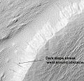
Nicholson Crater Central Mound, as seen by HiRISE. Click on image to see dark slope streak being diverted by an obstacle.
-

Bernard Crater Floor, as seen by HiRISE. Large cracks are visible on floor.
-
Dejnev Crater Floor, as seen by HiRISE. Scale bar is 500 meters long. Click on image to see large pits.
Dark slope streaks
Many places on Mars show dark slope streaks on steep slopes like crater walls. It seems that the youngest streaks are dark; they become lighter with age. Often they begin as a small narrow spot then widen and extend downhill for hundreds of meters. Several ideas have been advanced to explain the streaks. Some involve water.[11] or even the growth of organisms.[12][13] The streaks appear in areas covered with dust. Much of the Martian surface is covered with dust. Fine dust settles out of the atmosphere covering everything. We know a lot about this dust because the solar panels of Mars Rovers get covered with dust. The power of the Rovers has been saved many times by the wind, in the form of dust devils, that have cleared the panels and boosted the power. From these observations with the Rovers, we know that the process of dust coming out of the atmosphere then returning happens over and over.[14]
It is most generally accepted that the streaks represent avalanches of dust. The streaks appear in areas covered with dust. When a thin layer of dust is removed, the underlying surface is dark. Much of the Martian surface is covered with dust. Dust storms are frequent, especially when the spring season begins in the southern hemisphere. At that time, Mars is 40% closer to the sun. The orbit of Mars is much more elliptical then the Earth's. That is the difference between the farthest point from the sun and the closest point to the sun is very great for Mars, but only slight for the Earth. Also, every few years, the entire planet is engulfed in a global dust storm. When NASA's Mariner 9 craft arrived there, nothing could be seen through the dust storm.[10][15] Other global dust storms have also been observed, since that time. Dark streaks can be seen in the image below taken with HiRISE of the central mound in Nicholson Crater. At least one streak in the image splits into two when encountering an obstacle.
-
Nicholson Crater Central Mound, as seen by HiRISE. Click on image to see dark slope streak being diverted by an obstacle.
-

Minio Vallis Hanging Valleys, as seen by HiRISE. Two hanging valleys are visible, as well as many dark slope streaks.
-

Tinia Valles, as seen by HiRISE. Full size image shows dark slope streaks.
-

Labou Vallis, as seen by HiRISE. Ful size image shows old and new (darker) dark slope streaks.
Fossa on Mars
Large troughs (long narrow depressions) are called fossae in the geographical language used for Mars. This term is derived from Latin; therefore fossa is singular and fossae is plural.[16] Troughs form when the crust is stretched until it breaks. The stretching can be due to the large weight of a nearby volcano. A trough often has two breaks with a middle section moving down, leaving steep cliffs along the sides; such a trough is called a graben.[17] Lake George, in northern New York State, is a lake that sits in a graben.
Other ideas have been suggested for the formation of fossae. There is evidence that they are associated with dikes of magma. Magma might move along, under the surface, breaking the rock and more importantly melting ice. The resulting action would cause a crack to form at the surface. Dikes caused both by tectonic stretching (extension) and by dikes are found in Iceland.[18] An example of a graben caused by a dike is shown below in the image Memnonia Fossae, as seen by HiRISE.
It appears that the water started coming out of the surface to form Mangala Vallis when a graben was formed.[19][20]
-

Graben in Memnonia Fossae, as seen by HiRISE. This graben is believed to be the result of magmatic dikes rather than regional tectonic stretching. The scale bar is 1000 meters long.
-

Sirenum Fossae, as seen by HiRISE. More information can be found at Fossa (geology).
Valles
-

Mangala Valles, as seen by HiRISE.
-
Asopus Vallis, as seen by HiRISE.
-

Samara Valles, as seen by HiRISE. Scale bar is 500 meters long.
-

Padus Vallis, as seen by THEMIS. Padus Vallis empties into the Medusae Fossae Formation.
-

Close-up of Padus Vallis, as seen by THEMIS.
-
Mangala Vallis with a streamlined island, as seen by THEMIS.
-

Minio Vallis, as seen by THEMIS. Minio Vallis is a small river channel near the much larger Mangala Vallis.
-

Sabis Vallis, as seen by THEMIS. The small channels are joining to form Sabis Vallis.
See also
References
- ^ Davies, M.E.; Batson, R.M.; Wu, S.S.C. “Geodesy and Cartography” in Kieffer, H.H.; Jakosky, B.M.; Snyder, C.W.; Matthews, M.S., Eds. Mars. University of Arizona Press: Tucson, 1992.
- ^ USGS Astrogeology: Planetary Map Listing
- ^ http://hirise.lpl.arizona.edu/PSP_010281_1510
- ^ http://www.msss.com/http/ps/channels/channels.html
- ^ http://news.nationalgeographic.com/news/2009/11/091125-mars-crater-lake-michigan-water_2.html
- ^ http://themis.asu.edu/features/nilosyrtis
- ^ http://hirise.lpl.arizona.edu/PSP_004046_2080
- ^ http://hirise.lpl.arizona.edu?PSP_008437_1750
- ^ http://www.lpi.usra.edu/publications/slidesets/stones/
- ^ a b Hugh H. Kieffer (1992). Mars. University of Arizona Press. ISBN 9780816512577. http://books.google.com/books?id=NoDvAAAAMAAJ. Retrieved 7 March 2011.
- ^ http://www.space.com/scienceastronomy/streaks_mars_021200.html
- ^ http://www.spcae.com/scienceastronomy/streaks_mars_021211.html
- ^ http://www.space.com/scienceastronomy/streaks_mars_streaks_030328.html
- ^ http://www.sciencedaily.com/releases/2009/02/090217101110.htm
- ^ ISBN 0-517-00192-6
- ^ http://www.marsartgallery.com/marsnames.html
- ^ http://hirise.lpl.arizona.edu/PSP_008641_2105
- ^ http://hirise.lpl.arizona.edu/PSP_005376_1575
- ^ http://www.msss.com/http/ps/channels/channels.html
- ^ Michael H. Carr (2006). The surface of Mars. Cambridge University Press. ISBN 9780521872010. http://books.google.com/books?id=uLHlJ6sjohwC. Retrieved 21 March 2011.
External links
- http://www.lpi.usra.edu/meetings/lpsc2004/pdf/1439.pdf
- http://ralphaeschliman.com/atlasofmars/13axsm.pdf
- http://www.uapress.arizona.edu/onlinebks/mars/chap12.htm
Quadrangles on Mars MC-01 Mare Boreum
(features)MC-05 Ismenius Lacus
(features)MC-06 Casius
(features)MC-07 Cebrenia
(features)MC-02 Diacria
(features)MC-03 Arcadia
(features)MC-04 Acidalium
(features)MC-12 Arabia
(features)MC-13 Syrtis Major
(features)MC-14 Amenthes
(features)MC-15 Elysium
(features)MC-08 Amazonis
(features)MC-09 Tharsis
(features)MC-10 Lunae Palus
(features)MC-11 Oxia Palus
(features)MC-20 Sinus Sabaeus
(features)MC-21 Iapygia
(features)MC-22 Mare Tyrrhenum
(features)MC-23 Aeolis
(features)MC-16 Memnonia
(features)MC-17 Phoenicis Lacus
(features)MC-18 Coprates
(features)MC-19 Margaritifer Sinus
(features)MC-27 Noachis
(features)MC-28 Hellas
(features)MC-29 Eridania
(features)MC-24 Phaethontis
(features)MC-25 Thaumasia
(features)MC-26 Argyre
(features)MC-30 Mare Australe
(features)Categories:


Wikimedia Foundation. 2010.