- McArthur Lake
-
McArthur Lake 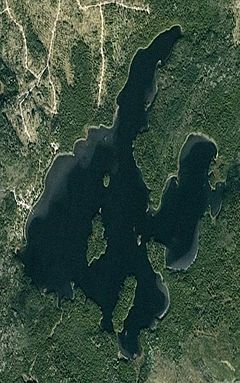
McArthur Lake as seen from space. 
North McArthur Island as seen from Olyjian Isle. Location Ontario, Canada Lake type Glacial Primary inflows Inflow Creek Primary outflows McArthur Creek Max. length 2.59 km (1.61 mi) Max. width 2.52 km (1.57 mi) Surface area 2.573 km² Average depth 3.5 m (11 ft) Max. depth 10 m (33 ft) Shore length1 13.82 km (8.59 mi) Surface elevation 328.2 m (1,077 ft) 1 Shore length is not a well-defined measure. McArthur Lake is located in Northern Ontario, about 40 km south of the city of Timmins. It is located about 10 km south southeast of Papakomeka Lake. The lake consists of 13 islands, three main peninsulas and three main bays. The lake lies in Timiskaming District. Over 20 camps and cottages are built on the west side of McArthur Lake. Popular sports here include fishing for pickerel[disambiguation needed
 ] (walleye) and Northern pike as well as kayaking or boating. Blueberry Island is the home to the only blueberries in the lake's region. The climate is very harsh; very few deciduous trees are found here. Most of the waterfront is rocky. The lake closes usually around October and re-opens when the snow and ice melt. The lake is approximately 1.5 km², and is said to reach a depth of roughly 35 feet, near Blueberry and Maziic islands. The average water temperature ranges from 25°C in July, to a chilling 14°C by October. Cedar and poplar trees are common here, as well as balsam fir and various types of pines. Various kinds of wildlife include: rabbits, bluejays and chickadees.
Contents
History
McArthur Lake was discovered in the early 1900s and was named after its discoverer. McArthur would often stop by at a convenience store in Timmins. He couldn't pay for the items that he bought and promised to pay the shopkeeper back later. When McArthur could pay the man back, he offered him six claims on his newly discovered lake. The shopkeeper's descendants still own these claims today.
Gold was found on the lake in what is believed to be one of six locations. There is also one copper and nickel vein to the south of the lake. A quartz vein, once believed to contain gold has been recently confirmed as containing none of the precious metal.
McArthur Lake became popular in the Timmins area in the 1950s and '60s. Because there was no garbage pickup from the moderately isolated lake, the cottagers needed a place to put their trash so bears would not invade their camps. An ideal island was found nearly a kilometer away from the main lodge and was large enough to sustain an immense amount of garbage. It was to become known as Blueberry Island. The island became so full that one of the only options to prevent another island from being trashed was to burn the garbage island. After the island was burned, a trash system was eventually devised into Timmins. Years after the burning, blueberries began to form on the island, hence its name. Trash can still be found on the south side of the island; old pop cans and beer bottles are the most common garbage still on the island.
 A Map of McArthur Lake with the main bays, peninsulas, islands, districts and district flags present.
Districts
There are four districts in which McArthur Lake is split up into: Northern, Eagle, Blueberry and Lodge. They make up the north, south, east and west parts of the lake, respectively. Each district contains at least three islands and a bay. Two of the four peninsulas are split between two districts leaving bays entirely in a given district.
Islands
There are thirteen islands in McArthur Lake. Most are accessible all year round, but a few can only be accessed during the spring (high water) or fall (very low water).
McArthur Island
This island is the largest on the lake being located just west of the geographical centre of the lake. The island is located in the westernmost Lodge District. It is about nine times larger than Sharprock Island, the second largest island. The island is mostly accessible by the south and on some west areas. The northwest side of the island has cliffs with the highest being about 20 feet high. Its shoreline is 1.15 km and its area is approximately 59,650 m².
Sharprock Island
The second largest island on McArthur Lake is located about 200 meters north northeast of McArthur Island. It is located in Northern District. The island is only accessible from the south side, near the sharp rocks (hence its name). All other points on the island have cliffs on the shore. The west side contains sparsely populated pine trees compared to the east side, which contains many dense and short tree types. Sharprock Island's shoreline is 0.31 km and has an area of about 6,590 m².
Blueberry Island
Blueberry Island is the third largest and most famous on the lake because of the garbage incident in the 1960s. The island is located in the easternmost Blueberry District. The deepest point in the lake is thought to be found near this island because of steep drop-offs and cliffs that the area possesses. The island is easily spotted by a large pine tree on the western side of the island which towers about 20' over other trees. Access is easiest on the north side, but the island can be accessed by the west side as well. The shoreline of Blueberry Island is about 0.24 km and has an area of about 3,340 m².
 Blueberry Island looking southwest as seen from Maziic Island.
Hidden Island
This island gets its name from the fact that it is hidden on the east side of Leech Bay on the north side of the lake. The fourth largest island is one of the few islands not made of bedrock. It is located in Northern District. The island is about 40' from shore and is accessible from any point, preferably not from a powerboat. Hidden Island has a shoreline of 0.23 km and has an area of approximately 2,780 m².
Delta Island
The fifth largest island in the lake lies in Lodge district about 200 meters southeast of McArthur Island. It gets its name from the idea that the nearby creek could have formed a delta and this island from it, lying in Lodge District. The island can be accessed from any point, although there are extremely shallow waters to the south (2 feet). The island's terrain is the most exaggerated of all of the islands. Delta Island has a shoreline of about 0.19 km and an area of 1,940 m².
Shadfly Island
This island, being sixth largest is located south of Grand Peninsula in McArthur Lake's The Archipelago. It can be found approximately 220 m north northeast of Blueberry Island, lying in Blueberry District. This island, as well as the other islands of The Archipelago, are named after small creatures that inhabit the lake. The island can be accessed from practically any point. There is an excellent fishing spot about 200' southeast of the island. Shadfly Island has a shoreline of about 0.20 km and has an area of 1,530 m².
Olyjian Isle
Olyjian Isle is the seventh largest island on the lake, but is only less than half the size of Shadfly Island. It is located about ten meters north of McArthur Island and both islands lie in Lodge District. Olyjian Isle is covered with only two tall trees but has many bushes and shrubs on the south side. The island is rocky and accessibility is easiest from the south. The island was named after a fictional four funneled ship from the late 19th century. Olyjian Isle has a shoreline of 117 m and has an area of 680 m².
Diorite Island
This island is located about 100 m northwest of Outflow Bay, in Lodge District. The island is also known colloquially as Half-Dead Island, as the vegetation on the island is dying. The island gets its name from the diorite rock that runs through to this island. It is the only island made with this rock. Accessibility is limited. The island's has a shoreline of 106 m and an area of 655 m².
Midway Island
The ninth largest island, located in the southernmost bay, Theriault Bay, was once thought to lie halfway between the north and south sides of the bay. The island lies in Eagle District. South of the island, the water is fairly shallow. The island in itself is low lying, making accessibility easy from any point. Midway Island has a shoreline of about 103 m and has an area of about 593m².
Crayfish Island
This island is the tenth largest island on the lake and the second largest in The Archipelago. It is located in Blueberry District, about 50 meters southeast of Shadfly Island. The island is rocky and accessibility is easiest to the south in a motorboat as the north side of the island contains shallow waters. The shoreline of Crayfish Island is about 91 m and the island has an area of about 430 m².
Maziic Island
Maziic Island is the eleventh largest on the lake. It is a bedrock island and is a very tall island for its small size. The island's northern rockier side is sometimes home to a seagull nest. Seagulls once nested on a rock about 30 m north of the island (aptly named Seagull Rock) but changed their nesting area to higher ground to avoid waves. The south part of the island is densely packed with trees, a significant contrast to the north. The island is very hard to access in low water because of its high rocks. Maziic Island was named after a fictional tanker because of its long boatlike appearance. The island has a shoreline of 88 m and an area af about 428 m².
Cat Island
The twelfth largest island on McArthur Lake is found in the north side of East Bay. It is the largest island in the bay. Cat Island has a few small coniferous trees and several bushes. The island lies in an area heavily marked with cattails and shallow water so accessibility is difficult. The shoreline of Cat island is about 81 m and has an area of about 426 m²
Outset Island
The island is the thirteenth largest on McArthur Lake and is the smallest main island, at 411 m². Outset Island was previously known as Taylor's Island. It rises about a half a metre above the waterline on the outskirts of Triple Bay. The island has a rock reef to its south that extends about three times its length into the lake. The island's 77 m shoreline consists of rocks mostly the size of cantaloupes, and it is not generally accessibly by motorboat because of the extensive shoal.
Anchor, Blackfly, Forest and Shoal Islands
These four islands lie to the east of McArthur Island, in The Archipelago, in Theriault Bay and outside of Interior Bay. They are all roughly the size of an outdoor backyard swimming pool. Anchor and Blackfly Islands consist of a few trees and slippery rocks on the shore. Forest Island is home to a myriad of densely packed trees and an eroded shore making accessibility impossible. Shoal Island appears for the summer-autumn part of the year, as the water is low. For the rest of the year, the high water levels cover the 20 cm high island comprised only of large stones.
Water Levels
The water level here fluctuates often (depending on rainfall and the quantity of snow melting), giving an average annual fluctuation of 1 to 1 1/2 feet (beginning from early spring April-May to mid summer July-August). Measurement taken in early spring calculate the water level immediately after snowmelt, typically giving the highest annual water level. This same measurement applies to mid-summer, when the climate is hot and dry, thus depriving the lake of water. Flat shorelines tend to become more exposed when water levels are low, than steep shorelines do. For example: the lake bottom at the McArthur Lake boat launch is relatively shallow and has little slope, therefore when the water level is 1 foot lower in mid-summer, an extra 3 feet of sand is extended outward toward the middle of the lake, which in turn, creates more difficulty when launching one's boat. Coordinates: 48°12′24″N 81°12′48″W / 48.206620°N 81.213210°W
Categories:- Lakes of Ontario


Wikimedia Foundation. 2010.