- Mbhashe Local Municipality
-
Mbhashe — Local municipality — Location in the Eastern Cape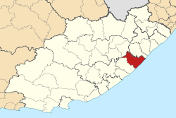
Coordinates: 32°10′S 28°35′E / 32.167°S 28.583°ECoordinates: 32°10′S 28°35′E / 32.167°S 28.583°E Country South Africa Province Eastern Cape District Amatole District Municipality Seat Dutywa Area - Total 3,050 km2 (1,177.6 sq mi) Population (2007)[1] - Total 262,008 - Density 85.9/km2 (222.5/sq mi) - Households 59,705 Racial makeup[2] (2007) - Black African 99.88% - White 0.03% - Coloured 0.02% - Indian or Asian 0.07% Time zone SAST (UTC+2) Municipal code EC121 Website http://www.mbhashemun.gov.za The Mbhashe Municipality is a remote outpost of the Eastern Cape of South Africa.
Its primary claim to fame is as the birthplace of the former president Thabo Mbeki. The Mbanyana Falls, Mbhashe Cultural Village and Donald Wood's Snooker Room number among its attractions.[3][dead link]
The name Mbashe is derived from Xhosa. The municipality is named after the Mbashe river that cuts through the three areas, namely Elliotdale, Willowvale and Idutywa.[4]
References
- ^ "Community Survey, 2007: Basic Results Municipalities" (PDF). Statistics South Africa. http://www.statssa.gov.za/Publications/P03011/P030112007.pdf. Retrieved 2009-10-20.
- ^ "Community Survey 2007 interactive data". Statistics South Africa. http://www.statssa.gov.za/community_new/content.asp?link=interactivedata.asp. Retrieved 19 October 2009.
- ^ Mbhashe Munipality
- ^ South African Languages - Place names
Province of Eastern Cape, South Africa Provincial Capital: Bhisho Metropolitan
MunicipalitiesBuffalo City · Nelson Mandela BayDistrict
and Local
MunicipalitiesCamdeboo · Blue Crane Route · Ikwezi · Makana · Ndlambe · Sunday's River Valley · Baviaans · Kouga · Kou-KammaInxuba Yethemba · Tsolwana · Inkwanca · Lukhanji · Intsika · Emalahleni · Engcobo · SakhisizweElundini · Senqu · Maletswai · GariepCategories:- Local Municipalities of Amatole

Wikimedia Foundation. 2010.