- Narrows Bridge (Perth)
-
 The Narrows Bridge seen prior to the completion of the railway line
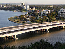
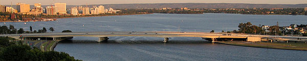
The Narrows Bridge is a freeway crossing of the Swan River in Perth, Western Australia, at The Narrows between Mill Point and Mount Eliza. Made up of two road bridges and a railway bridge, it connects the Mitchell and Kwinana Freeways, linking the city's northern and southern suburbs. The original road bridge was opened in 1959 and was the largest precast prestressed concrete bridge in the world. Construction of the northern interchange for this bridge necessitated the reclamation of a large amount of land from the river.
The bridge formed part of the Kwinana Freeway which originally ran for only 2.4 miles (3.9 km). Over the following decades, the freeway system was expanded to the north and south, greatly increasing the volume of traffic using the bridge. As a result, in 2001, a duplicate traffic bridge was opened to the west of the original bridge, and in 2005, the railway bridge was constructed in the gap between the two traffic bridges. Passenger trains first traversed the Narrows in 2007 with the opening of the Mandurah railway line.
Contents
First road bridge: 1959
Narrows Bridge
Southbound
The bridge viewed from Kings Park, circa 1959Carries Kwinana Freeway
(Southbound road lanes)Crosses Swan River Maintained by Main Roads Western Australia Designer Sir William Holford Material Reinforced concrete Total length 396.5 m (1,301 ft)[1] Width 27.4 m (90 ft)[1] Longest span 320 ft (98 m) Number of spans 5 Piers in water 2 Construction begin 8 June 1957 Opened 13 November 1959 Heritage status WA Heritage Register Coordinates 31°57′48″S 115°50′49″E / 31.96333°S 115.84694°ECoordinates: 31°57′48″S 115°50′49″E / 31.96333°S 115.84694°E  The original Narrows Bridge under construction, c. 1957
The close distance between Mill Point and Point Lewis at the foot of Mount Eliza meant the site was suggested as a suitable location for a bridge as early as 1849.[2] A bridge was proposed for the site in 1899, but its expected cost of £13,000 was deemed too expensive.[3] Preliminary planning for a bridge at the site finally began in 1947, but was suspended so that a replacement, The Causeway, could be built at Heirisson Island, at the city's eastern end.[4] The new Causeway bridges were opened in 1952, and by 1954 traffic using them to enter the city had doubled, renewing calls for a bridge at The Narrows.[4]
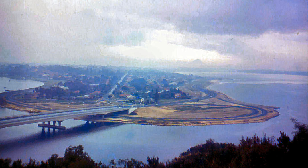
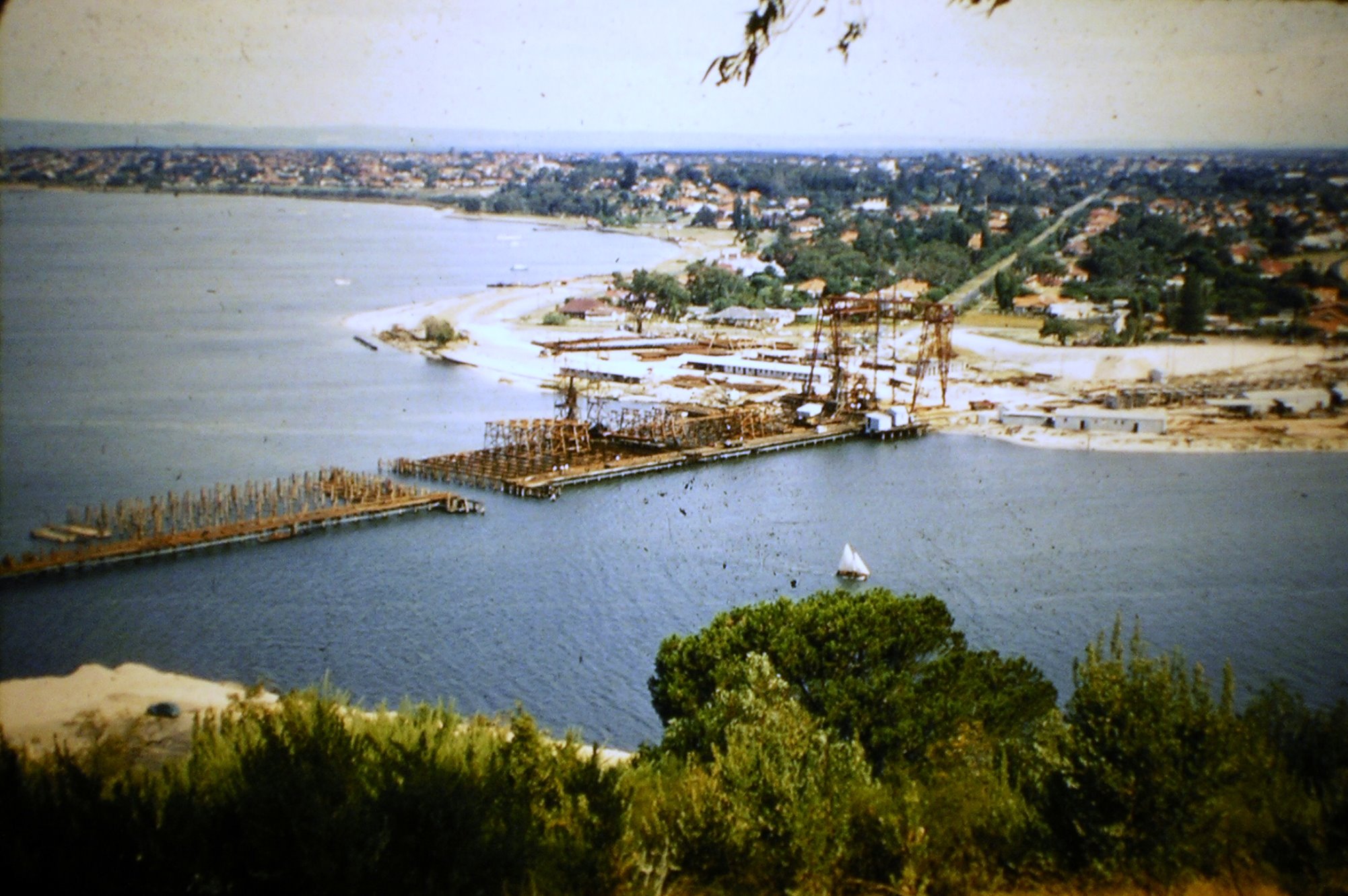
Site investigations for the bridge began in August 1954.[4] The bridge was proposed for The Narrows site by the Town Planning Commission under the chairmanship of Harold Boas.[5] The chosen site drew public protest on the basis that the bridge would spoil the view to and from the city.[6] Also, residents of the wealthy Mill Point area were angry that they would have a major highway running beside their houses.[6] The site also necessitated the reclamation of 60 acres (24 ha) of land from Mounts Bay for the bridge approach and interchange.[7] This land reclamation, which started in October 1954, saw the addition of 4,500,000 cubic yards (3,400,000 m3) of sand, much of which was dredged from Melville Water.[7]
The State started saving for the new bridge in September 1954,[8] and the construction of the bridge was approved by the Hawke state Labor government in November 1954, before the Hepburn-Stephenson metropolitan roads plan had been finalised, such was the urgency of a new traffic link.[2] The construction of the bridge was subsequently endorsed in the 1955 Hepburn–Stephenson plan,[5] which later developed into the Metropolitan Region Scheme.
The river bed at the site of the proposed bridge was not ideal for bridge building, with soft mud extending down up to 80 feet (24 m), with sand beds below that going a further 40 feet (12 m) down.[7] Ernie Godfrey, a bridge engineer with the Main Roads Department, travelled overseas to inspect bridges in similar geological locations and to source a designer for the proposed bridge.[4] The design contract for the bridge was won by British engineering firm Maunsell & Co.[4]
Construction on the road system began in 1956,[9] and the contract for construction of the bridge was signed by Commissioner of Main Roads J. Digby Leach on 16 March 1957.[10] The bridge was built by Danish firm Christiani and Nielsen in conjunction with Western Australian engineering firm J. O. Clough & Son.[4] Leif Ott Nilsen oversaw construction on behalf of Christiani and Nielsen.[11] The first timber pile for the temporary staging for the construction was driven at noon on 8 June 1957.[12] The first permanent pile for the bridge was driven home on 18 August 1957.[12] Work on the bridge's precast concrete beams began in September 1957, and the first of these was lifted into place by the 60-foot (18 m) gantry crane in February 1958. The last river pile was driven home in November 1958, and the final concrete beam was lowered into position in June 1959.[12]
During construction on 10 February 1959, John Tonkin, then the Deputy Premier and Minister for Works, announced that the new bridge was to be named the Golden West Bridge.[9] However, Golden West was also the name for a popular soft drink;[13] the proposal encountered scorn from commentators and was quietly dropped.[9]
The bridge cost £1.5 million, as part of a wider road system costing £3.5 million.[14] Construction on the bridge took 2 years and 5 months.[14] It was officially opened by Governor Sir Charles Gairdner on 13 November 1959.[8] He unveiled a plaque on the bridge together with Premier Sir David Brand, Commissioner of Main Roads J. Digby Leach and Works Minister Wild.[8] Gairdner was also the first person to drive across the new bridge.[8] It was hoped at this stage that the debt raised to pay for the bridge would be repaid by the Government within 12 months.[8]
The bridge formed part of the new Kwinana Freeway, which originally ran 2.4 miles (3.9 km) from the Narrows to Canning Highway.[15] This was described as the "most modern highway" in Western Australia, with a speed limit of 50 miles per hour (80 km/h).[15] The bridge was also the largest precast prestressed concrete bridge in the world at the time of its opening.[16]
Design
The bridge was jointly designed by engineering firm G. Maunsell & Partners and architects William Halford & Partners.[1] The prestressed concrete design was relatively new for Western Australia, where road bridges had traditionally been built from timber frameworks.[4] The bridge is arched along its length, with a vertical curve of up to 4% grade.[10]
The unusually soft soil conditions at the site forced the use 160 "Gambia piles" for the bridge's foundations, named after the country in which they were first used.[7] The 31-inch (79 cm) diameter piles have steel shells and conical noses.[7] The hollow piles were driven by a drop hammer falling within them, then when they had sufficient resistance to driving, they were filled with reinforced concrete.[7]
The piles support two river piers, two shore piers and two abutments.[10] The bridge's support columns on the piers were designed in a triangular form, larger at the top than at the bottom, each carrying two of the bridge's beams, so as to not completely obstruct the view through the bridge's piers.[10] These columns support the bridge's five spans: a central span of 320 feet (98 m), two flanking spans of 230 feet (70 m) each and two smaller spans of 160 feet (49 m) at each end passing over roadways.[10] The bridge has eight parallel lines of beams.[10] Each line of beams consists of two cantilever spans 370 feet (110 m) long suspended between the shore and river piers, a central suspended span 140 feet (43 m) long between the two river piers, and two 110-foot (34 m) spans suspended over roadways at either end.[10] Suspended between the beams of the bridge were 1 mile (1.6 km) of 30-inch (76 cm) water mains pipes and 0.5 miles (800 m) of 10.5-inch (27 cm) gas and drainage pipes.[15]
Footpaths 8 feet (2.4 m) wide on either side of the bridge were formed by concrete cast in situ and cantilevered out from the adjacent beams.[10] These footpaths were separated from the roadway and the bridge's edge by lightweight aluminium balustrades and safety fences installed by Bristile.[17] The street lights were integrated into the safety fence.[10]
The deck of the bridge was formed by pre-casting individual concrete units on the southern river shore, then hoisting them into place on temporary timber staging in the river.[10] The units were then structurally joined by strands of high-tensile wire and stretched with a hydraulic jack.[10] These pre-stressing strands were anchored in reinforced concrete blocks at the ends of the spans.[10] The new bridge had a traffic capacity of 6,000 cars per hour in each direction,[10] over a total of six traffic lanes.[18]
Post-completion history
Strengthening works were carried out on the bridge by Structural Systems Ltd in 1996.[19] Also in 1996, decorative night lighting was installed on each side of the bridge.[20] The bridge was entered on the state's heritage register on 8 January 1999,[21] and was named a national engineering landmark by the Institution of Engineers, Australia, in November 1999.[22]
The opening of the southern regions of Perth to easier central business district access changed the nature of the metropolitan area, prompting dramatic population growth south of the river.[23] This led to increased traffic on the bridge, causing regular traffic jams in peak hour. Over the years, governments suggested various ideas to reduce the traffic using the bridge, including introducing congestion pricing similar to that used in Singapore, charging vehicles to enter the central business district during peak periods.[23] The government also encouraged voluntary car sharing.[23] These efforts were largely unsuccessful, and by the 1990s, the bridge had become the city's worst traffic bottleneck,[23] despite the addition of an extra traffic lane, bringing the total number of lanes to seven.[18]
“ Peak-hour users of the freeway have become accustomed to driving into a bottle-neck every day. They also know that it takes only a minor bingle on the bridge to turn the freeway into a vast parking lot, inciting road rage symptoms and making thousands of people late for work. ” —Journalist Andre Malan, The West Australian, 7 March 1998[23]
Second road bridge: 2001
Narrows Bridge
Northbound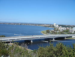
The duplicate bridge seen here in the foreground, with the darker road surface.Carries Kwinana Freeway (Northbound road lanes);
Northbound railway lineCrosses Swan River Maintained by Main Roads Western Australia Plans for a second Narrows Bridge were mooted during the 1970s, but did not eventuate.[6] By 1998, the original bridge was carrying 155,000 vehicles per day, with an average of 2,700 cars per lane between 7:30 am and 8:30 am, and was thought to be the busiest section of freeway in the country.[6] This quantity of traffic far outstripped the expected capacity of the bridge when it opened in 1959.[10] The solution to the traffic problem most favoured by road planners in 1998 was to widen the existing bridge by building a smaller second traffic bridge just west from it and joining their decks to form a contiguous roadway.[23] This would increase the number of traffic lanes from seven to 10.[23] The widening was expected to cost $50 million.[23]
A plan to widen the Narrows Bridge was announced on 13 April 1998 by the Court Liberal State Government.[24] The $70 million plan would involve the addition of four extra traffic lanes,[24] and was part of a $230 million package upgrading and extending the southern end of the Kwinana Freeway.[25] Alannah McTiernan, then the Opposition Transport spokesperson, attacked the plan, saying that the government should instead build a railway to Rockingham.[24]
Instead of widening the existing structure, Transport Minister Eric Charlton on 15 July 1998 approved the construction of a separate second road bridge alongside the original Narrows Bridge;[26] this solution would cost $15 million less, due to new building techniques, and would be less disruptive to traffic on the existing bridge.[27] The construction of a separate bridge was also deemed necessary because the foundations of any new structure might settle in the soft river bed at a different rate to the existing bridge.[27] Under the plan, there would be six lanes on each bridge, including a bus lane on each.[27] The new bridge would run parallel to the original bridge and be separated from it by a gap of 6 metres (20 ft),[27] and was designed to look largely the same as the original.[28]
Main Roads called for tenders for the bridge widening in July 1998,[29] and on 7 March 1999 it was announced that the building contract had been awarded to Leighton Contractors.[30] The negotiated contract price was reduced to $49 million owing to the construction method proposed by Leighton.[31] The designers were Connell Wagner.[32]
The bridge was constructed by the incremental launching technique, with 28-metre (92 ft) segments pre-cast on both shores and pushed out into place as the construction progressed.[33][34] The bridge was divided into two strips lengthways, with the eastern half launched separately from the western half, and the two decks were later joined at the bridge's centre line.[35] The first of twelve segments[36] was launched in February 2000.[37]
As it was being launched, the bridge rested on temporary piles; only after the structure was fully launched were these piles removed and the bridge allowed to rest on its permanent supports.[33] The construction required the driving of around 250 steel piles; the first was driven on 10 August 1999.[38]
Construction of the second bridge was interrupted several times by strikes,[39] as well as by an algal bloom in the Swan River.[40] The bridge was finally opened to traffic on 26 February 2001,[41] and officially opened by new Transport Minister Alannah McTiernan (a strident critic of the project) on 30 May 2001.[42] The bridge had originally been planned to be opened in August 2000,[41] and was expected to carry 80,000 cars per day.[42] The new traffic bridge carried six lanes of traffic, including one bus lane, and the original bridge was modified at this time to carry six traffic lanes, as designed.[18]
Railway bridge: 2005
Narrows Rail Bridge Carries Southbound railway line Crosses Swan River Number of spans 5 Piers in water 2 Opened 23 December 2007 During the construction of the second road bridge, the construction of a railway through Perth's southern suburbs to Rockingham and Mandurah became a political issue.[43] The incumbent Liberal State Government proposed building a railway from Kenwick to connect to the Kwinana Freeway, running in the centre of the freeway for only part of its journey.[44] The Labor opposition instead wanted to build the railway across the Narrows Bridge and down most of the length of the freeway.[44]
After the Labor party won the 2001 state election, they reversed the previous government's position and started planning for the installation of railway tracks across the Narrows Bridge.[45] Leighton Constructions won the contract to build the freeway stage of the railway line and set about constructing a narrow southbound railway bridge in the 6-metre (20 ft) gap between the existing road bridges.[46][47] The designers of "Package E" of the Southern Suburbs Railway (which included the Narrows Rail Bridge) were GHD, Coffey Geosciences and Wyche Consulting.[48] The eastern side of the existing northbound (2001) bridge was also strengthened to accommodate the northbound railway track.[46][47] Construction was due to start in July 2005 and completion was expected by December 2005.[49] The first passengers traversed the Narrows on 23 December 2007 with the opening of the Mandurah Railway Line.[50]
The railway bridge deck was made from nine steel girders each weighing up to 99.5 tonnes (219,000 lb)[51] and up to 54 metres (177 ft) long.[52] These girders were built in Kwinana, brought to the site by road and lowered into position with a crane.[47]
 The bridges viewed from the west at sunset.
Notes
- ^ a b c "Second Narrows Bridge". Structurae. http://en.structurae.de/structures/data/index.cfm?ID=s0005065. Retrieved 27 November 2008.
- ^ a b Gregory, p. 106
- ^ Gauntlett, Kate (6 January 2001). "Public To Preview New Narrows". The West Australian: p. 40.
- ^ a b c d e f g Gregory, p. 107
- ^ a b Seddon, George; David Ravine (1986). A city and its setting: images of Perth, Western Australia. Fremantle: Fremantle Arts Centre Press. pp. 83 & 187. ISBN 0949206083.
- ^ a b c d Anthony, Shaun (13 April 1998). "Bridge Plan Revives Old Animosities". The West Australian: p. 8.
- ^ a b c d e f "Narrows Opening", p. 33
- ^ a b c d e Staff writer (13 November 1959). "A Day For Our History Book". Daily News: pp. 1 & 3.
- ^ a b c Gregory, p. 108
- ^ a b c d e f g h i j k l m n "Narrows Opening", p. 30
- ^ "Narrows Opening", p. 31
- ^ a b c "Narrows Opening", p. 34
- ^ Malan, Andre (11 May 2000). "Finding The Road To Immortality". The West Australian: p. 20.
- ^ a b "Narrows Opening", p. 25
- ^ a b c "Narrows Opening", p. 27
- ^ Anon. 1959, World's largest precast prestressed concrete bridge completed, Roads and Road Construction, v. 37, n. 444, pp. 364-367.
- ^ "Narrows Opening", p. 29
- ^ a b c "Dualling of Narrows Bridge should be completed by end of 2000" (Press release). Minister for Transport. 7 March 1999. http://www.mediastatements.wa.gov.au/Lists/Statements/DispForm.aspx?ID=110123. Retrieved 5 February 2009. "The existing bridge, built 40 years ago as a six lane bridge, currently has seven lanes but this will be reduced to six with extra lane width contributing to improved safety and driver comfort."
- ^ "Structural Systems Ltd: Update On Profit (Part A)". Australian Stock Exchange Company Announcements. 21 February 1996. "Works have now commenced on both the Ampolex Wandoo Gravity Structure and the Woodman Point Digesters in Western Australia and the group has recently been awarded a major contract for strengthening works on the Narrows Bridge in Perth."
- ^ Lingane, Dennis (3 January 1997). "City Of Lights". The West Australian: p. 4. "But the decision in the end was to use the stark neon light strip that was turned on last Australia Day. It looks like a slash across the river. Like it or not, it was preferred by architects because it was the style proposed for the bridge when it was built in the 1950s."
- ^ Tickner, Liz (9 January 1999). "Narrows Bridge On Heritage List". The West Australian: p. 11.
- ^ Zekulich, Michael (13 November 1999). "Viking Invaders Came On Mission". The West Australian: p. 5.
- ^ a b c d e f g h Malan, Andre (7 March 1998). "Narrows Problem Widens". The West Australian: p. 14.
- ^ a b c Anthony, Shaun (13 April 1998). "State's $70m Plan To Widen Narrows". The West Australian: p. 1.
- ^ Mendez, Torrance (14 April 1998). "Clash Over Need For A Wider Narrows". The West Australian: p. 7.
- ^ Mendez, Torrance; Mark Mallabone (12 August 1998). "How it will look". The West Australian: p. 4.
- ^ a b c d Mendez, Torrance (11 August 1998). "Charlton Approved New Bridge". The West Australian: p. 3.
- ^ Kirk, Alan (19 October 1999). "Safety First". The West Australian: p. 3.
- ^ Staff writer (31 July 1998). "Bridge widening". The Australian: p. 38.
- ^ Malpeli, Gareth (8 March 1999). "Leighton To Build Narrows Bridge". The West Australian: p. 28.
- ^ Grove, Jennifer (27 March 1999). "Narrows Cost Cut By $21m". The West Australian: p. 32.
- ^ "CV Bridge Designers...". miningjob.net. http://www.miningjob.net/cv.nsf/v/js83434. Retrieved 28 November 2008. "CONNELL WAGNER – SENIOR ENGINEER ( 1999 – 2000) I was involved with the following projects: 1. Duplication of Narrows Bridge Project, WA"
- ^ a b Scott Martin (2 June 1999). "Media Statement: Narrows bridge duplication underway". Leighton Constructions. Archived from the original on 21 February 2001. http://web.archive.org/web/20010221153414/www.narrows.wantree.com.au/LCPLMedia2.htm. Retrieved 27 November 2008.
- ^ Kirk, Alan (19 October 1999). "No problems". The West Australian: p. 4.
- ^ Robb, Trevor (10 October 2000). "Narrows Clone Nearing Touch Down". The West Australian: p. 13.
- ^ John Dunkley (28 February 2000). "Media Statement: World first narrows the distance". Leighton Constructions. Archived from the original on 22 February 2001. http://web.archive.org/web/20010221082914/www.narrows.wantree.com.au/LCPLMedia10.htm. Retrieved 27 November 2008.
- ^ Scott Martin (25 February 2000). "Media Statement: World first narrows the distance". Leighton Constructions. Archived from the original on 22 February 2001. http://web.archive.org/web/20010222023305/www.narrows.wantree.com.au/LCPLMedia9.htm. Retrieved 27 November 2008.
- ^ Scott Martin (9 August 1999). "Media Statement: Work starts on the Narrows duplication tomorrow". Leighton Constructions. Archived from the original on 21 February 2001. http://web.archive.org/web/20010221153005/www.narrows.wantree.com.au/LCPLMedia5.htm. Retrieved 27 November 2008.
- ^ See e.g. Manly, Chris (1 February 2000). "Workers Walk Off Bridge Site". The West Australian: p. 7.
- ^ Manly, Chris (17 February 2000). "Scare Stops Work On Narrows Bridge". The West Australian: p. 5.
- ^ a b Miller, Nick (27 February 2001). "Gawking Drivers Slow Arch Flow". The West Australian: p. 3.
- ^ a b Kent, Melissa (31 May 2001). "MacTiernan Does Bridge Turnabout". The West Australian: p. 4.
- ^ See e.g. Butler, Julie (20 October 2000). "Railway Winners". The West Australian: p. 10.
- ^ a b Robb, Trevor (17 July 2001). "Rail Switch: New Train Link Across City Foreshore". The West Australian: p. 1.
- ^ Banks, Amanda (7 July 2004). "Perth to Mandurah railway". The West Australian: p. 19.
- ^ a b Armstrong, Grahame (18 January 2004). "Leighton wins rail contract". Sunday Times: p. 16.
- ^ a b c "Freeway Works". Public Transport Authority of Western Australia. Archived from the original on 26 April 2007. http://web.archive.org/web/20070426032720/www.newmetrorail.wa.gov.au/Default.aspx?tabid=46. Retrieved 27 November 2008.
- ^ Noel Wenham. "Incremental Launching Challenges on Mount Henry Bridge" (PDF). Wyche Consulting. http://wyche.com.au/wp-content/uploads/2007/05/Incremental%20Launching%20Challenges%20on%20Mount%20Henry%20Bridge.pdf. Retrieved 28 November 2008. "The main bridgeworks for the rail project, including the Mount Henry Bridge, the Narrows Bridge and the Canning bus bridge amongst others, were grouped under one contract called “Package E”, which was awarded to Leighton Contractors in January 2004. The Leighton Contractors design team for Package E consisted of Coffey Geosciences, GHD and Wyche Consulting."
- ^ "Annual Report 2005". Public Transport Authority of Western Australia. 2005. pp. 8. Archived from the original on 25 July 2008. http://web.archive.org/web/20080725023936/http://www.pta.wa.gov.au/annualreports/2005/12.asp. Retrieved 27 November 2008.
- ^ Staff writer (23 December 2007). "1500 take first railway trip to Mandurah". thewest.com.au (The West Australian). Archived from the original on 28 February 2008. http://web.archive.org/web/20080228232646/http://www.thewest.com.au/default.aspx?MenuID=77&ContentID=52023. Retrieved 19 January 2009.
- ^ Staff writer (2005). Roads Matter. Issue 14, 2005. p. 17.
- ^ "New Narrows Bridge". Public Transport Authority of Western Australia. Archived from the original on 28 April 2007. http://web.archive.org/web/20070428100711/www.newmetrorail.wa.gov.au/Default.aspx?tabid=200. Retrieved 27 November 2008.
References
- Gregory, Jenny (2003). City of light: a history of Perth since the 1950s. Perth: City of Perth. ISBN 0959463259.
- Staff writer (13 November 1959). "The Narrows Bridge Opens Today". The West Australian. ("Narrows Opening")
External links
- State Library of Western Australia Pictorial Collection — photographs of the bridges under construction
- Western Australian Register of Heritage Places listing for the original bridge
- Structurae page on the original bridge
 Road infrastructure in Perth
Freeways 
Highways Bridges Canning Bridge · The Causeway · Horseshoe Bridge · Mount Henry Bridge · Narrows Bridge · Redcliffe Bridge · Riverton Bridge · Stirling BridgeCategories:- Road bridges in Australia
- Landmarks in Perth, Western Australia
- Bridges in Perth, Western Australia
- Bridges completed in 1959
- Swan River (Western Australia)


Wikimedia Foundation. 2010.