- Maryland Route 265
-
Maryland Route 265
Mackall Road 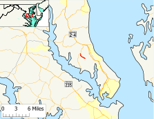
Route information Maintained by MDSHA Length: 1.75 mi[1] (2.82 km) Major junctions South end: Beginning of state maintenance near Mutual North end:  MD 264 in Mutual
Location Counties: Calvert Highway system Maryland highway system
Interstate • US • State • Minor • Former • Turnpikes← MD 264MD 267  →
→Maryland Route 265 (MD 265) is a state highway in the U.S. state of Maryland. Known as Mackall Road, the state highway runs 1.75 miles (2.82 km) from the beginning of state maintenance near Mutual north to MD 264 in Mutual. MD 265 was constructed around 1930. The state highway originally extended south through Wallville to St. Leonard Creek. MD 265's southern terminus was moved north four times between 1962 and 1995.
Contents
Route description
MD 265 begins at an arbitrary point on Mackall Road 0.10 miles (0.16 km) south of Constitution Drive near Mutual. Mackall Road continues south as a county highway through Wallville and Mackall to the end of the road at St. Leonard Creek near the Jefferson Patterson Park and Museum. MD 265 heads north as a two-lane road to the community of Mutual, where the highway reaches its northern terminus at MD 264 (Broomes Island Road), which continues north to an intersection with MD 2 and MD 4 (Solomons Island Road) in Port Republic.[1][2]
History
MD 265 originally extended south from Mutual 7 miles (11 km) to the hamlet of Mackall at the mouth of St. Leonard Creek.[3] The first section of the state highway was constructed as a gravel road from Mutual in 1929.[4] The second segment was added in 1930, reaching south to 1 mile (1.6 km) north of Wallville.[4][5] MD 265 was completed to St. Leonard Creek between 1930 and 1933.[4][6] The state highway has been progressively truncated since 1962 when the southern terminus was rolled back from St. Leonard Creek to north of Wallville.[7] MD 265 was truncated again in 1963 and 1967 before the final adjustment around 1995 that resulted in the state highway's current length.[8][9][10]
Junction list
The entire route is in Mutual in Calvert County.
Mile[1] Destinations Notes 0.00 Mackall Road south – Wallville Southern terminus; beginning of state maintenance 1.75 MD 264 (Broomes Island Road) – Broomes Island, Port RepublicNorthern terminus 1.000 mi = 1.609 km; 1.000 km = 0.621 mi References
- ^ a b c "Highway Location Reference: Calvert County" (PDF). Maryland State Highway Administration. 2009. http://www.marylandroads.com/Location/2009_CALVERT.pdf. Retrieved 2011-01-28.
- ^ Google, Inc. Google Maps – Maryland Route 265 (Map). Cartography by Google, Inc. http://maps.google.com/maps?f=d&source=s_d&saddr=MD-265%2FMackall+Rd&daddr=MD-265%2FMackall+Rd&hl=en&geocode=FXnCSgIdwkNw-w%3BFWIFSwIdpPVv-w&mra=ls&sll=38.454521,-76.529753&sspn=0.003856,0.009645&ie=UTF8&t=h&z=14. Retrieved 2011-01-28.
- ^ Maryland State Roads Commission. Maryland: Official Highway Map (Map) (1959 ed.).
- ^ a b c Report of the State Roads Commission of Maryland. 1927-1930. Baltimore: Maryland State Roads Commission. 1930-10-01. p. 200. http://www.archive.org/details/reportofstateroa1927mary. Retrieved 2011-01-28.
- ^ Maryland Geological Survey. Map of Maryland Showing State Road System: State Aid Roads and Improved County Road Connections (Map) (1930 ed.).
- ^ Maryland Geological Survey. Map of Maryland Showing State Road System: State Aid Roads and Improved County Road Connections (Map) (1933 ed.).
- ^ Maryland State Roads Commission. Maryland: Official Highway Map (Map) (1962 ed.).
- ^ Maryland State Roads Commission. Maryland: Official Highway Map (Map) (1963 ed.).
- ^ Maryland State Roads Commission. Maryland: Official Highway Map (Map) (1967 ed.).
- ^ Maryland State Highway Administration. Maryland: Official Highway Map (Map) (1995 ed.).
External links
Roads in Calvert County, Maryland State highways 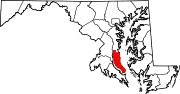 Categories:
- State highways in Maryland
- Roads in Calvert County, Maryland


Wikimedia Foundation. 2010.