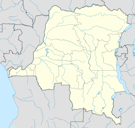
- Marungu highlands
-
Marungu highlands Elevation 2,460 m (8,071 ft) Location Coordinates 7°07′54″S 29°41′41″E / 7.131554°S 29.694672°ECoordinates: 7°07′54″S 29°41′41″E / 7.131554°S 29.694672°E The Marungu highlands are in the Katanga Province of the Democratic Republic of the Congo, to the west of the southern half of Lake Tanganyika.
Location
The highlands are divided by the Mulobozi River, which flow into the lake just north of Moba port. The northern section reaches an altitude of 2,100 metres (6,900 ft) while the larger southern part reaches 2,460 metres (8,070 ft). Mean annual rainfall is around 1,200 millimetres (47 in), mostly falling between October and April. The soil is relatively low in nutrients. The higher parts of the highlands are grassland, with scrub on the slopes and some dense forest in the ravines and remains of riparian forest along the streams. Forest plants include Parinari excelsa, Teclea nobilis, Polyscias fulva, Ficus storthophylla and Turrea holstii in ravines, and Syzygium cordatum, Ficalhoa laurifolia and Ilex mitis by the water.[1]
Environmental concerns
The Marungu highlands riparian forest patches are in great danger of destruction from logging and from stream bank erosion by cattle. The Greater Double-collared Sunbird (Nectarinia prigoginei) is found only in the riparian forest of this area. There have been proposal to convert the forests that border the Mulobozi and Lufoku rivers above 1,500 metres (4,900 ft) into conservation areas.[1] Hyperolius nasicus is a small, slender tree frog with a markedly pointed snout, a very poorly known member of the controversial Hyperolius nasutus group. It is known only from its type locality in the Marungu highlands at Kasiki, at 2,300 metres (7,500 ft).[2]
References
- ^ a b "Marungu highlands". Birdlife. http://www.birdlife.org/datazone/sitefactsheet.php?id=6072. Retrieved 2011-11-02.
- ^ "Hyperolius nasicus Laurent, 1943". African Amphibians Lifedesk. http://africanamphibians.lifedesks.org/pages/25670. Retrieved 2011-11-02.
Categories:- Geography of Katanga Province
- Katanga (province)
Wikimedia Foundation. 2010.

