- Martindale, Cumbria
-
Coordinates: 54°33′25″N 2°52′39″W / 54.557°N 2.8775°W
Martindale 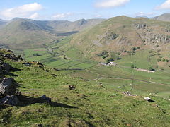
The mid and upper parts of Martindale from Steel Knotts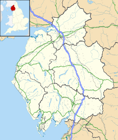
 Martindale
Martindale shown within CumbriaPopulation 49 (2001) OS grid reference NY4319 Parish Martindale District Eden Shire county Cumbria Region North West Country England Sovereign state United Kingdom Post town PENRITH Postcode district CA10 Dialling code 01768 Police Cumbria Fire Cumbria Ambulance North West EU Parliament North West England UK Parliament Penrith and The Border List of places: UK • England • Cumbria Martindale is a valley and civil parish in Cumbria, England, situated within the Lake District National Park between the lakes of Ullswater and Haweswater. The valley is served by a narrow minor road which runs as far as the farm of Dale Head.
Contents
Description
Martindale runs for approximately nine km in a north to south direction, it is a remote and thinly populated valley which has a permanent population of only about 50 residents.[1] The foot of the valley is located at the small hamlet of Sandwick on the western shore of Ullswater, while its head is situated on the slopes of Rampsgill Head where the headwaters of Howegrain Beck rise at a height of around 700 metres above sea level. The upper part of the valley is divided into two branches by the fell of The Nab, these two sub valleys named Bannerdale and Rampsgill contain the streams of Bannerdale Beck and Rampsgill Beck which meet at a point midway down Martindale to form Howegrain Beck which then becomes the main watercourse for the lower part of Martindale and enters Ullswater at Sandwick.[2][3] Just before reaching Sandwick, Martindale is joined by the side valley of Boredale, which enters from the south.
Deer reserve
The upper part of Martindale around The Nab is a deer reserve which is not open to the public and contains no rights of way. The reserve is home to the oldest native red deer herd in England. Hill walkers are requested by the Dalemain Estate, which owns the reserve, to keep to preferred routes which avoid the herds when climbing The Nab, to which there is now open access under the Countryside and Rights of Way Act 2000.[4]
At the foot of The Nab is “The Bungalow”, this is a former shooting lodge which was constructed in 1910 by Hugh Lowther, 5th Earl of Lonsdale for a deer shooting visit by the German Emperor Wilhelm II in 1910. Today The Bungalow is used as self catering accommodation which houses 12 people.[5]
Habitations
 The Bungalow in the deer reserve.
The main area of habitatiion in the valley is situated in its lower area where the road comes over the hause from Howtown. Here there is Hause Farm, The Old Reading Room and a few self catering holiday homes. At the top of the hause is St Peter’s Church often referred to as the New Church, it dates from 1880.[6] Half a kilometre further up the valley is the restored St Martin’s Church, the present building dates from the end of the 16th century.[7] Other farm buildings in the mid and upper parts of Martindale are Winter Crag, Knicklethorns, Henhow, Thrang Crag and Dale Head.
Martindale is surrounded by the Far Eastern Fells and is a popular starting point for hillwalking. One of the most popular walks is the Martindale Skyline, a 16 km walk with just over 1000 metres of ascent which takes in many of the peaks around the valley including Beda Fell and Steel Knotts.[8]
References
- ^ English Lakes website. Gives population of valley as "about 50 permanent residents"..
- ^ Landscape Heritage. Gives general details of Martindale.
- ^ "Wainwright In The Valleys Of Lakeland", Alfred Wainwright, Page 69, ISBN 0 7181 3481 8, Gives general description of Martindale.
- ^ www.dalemain.com. Gives details of deer reserve.
- ^ www.dalemain.com. Gives details of The Bungalow.
- ^ Visit Cumbria. Gives details of new church.
- ^ Visit Cumbria. Gives details of old church.
- ^ BBC Cumbria. Gives details of Martindale Skyline walk.
Ceremonial county of Cumbria Cumbria Portal Boroughs or districts City of Carlisle • Borough of Allerdale • Borough of Barrow-in-Furness • Borough of Copeland • District of Eden • District of South LakelandMajor settlements Alston • Ambleside • Appleby-in-Westmorland • Aspatria • Barrow-in-Furness • Bowness-on-Windermere • Brampton • Broughton-in-Furness • Carlisle • Cleator Moor • Cockermouth • Dalton-in-Furness • Egremont • Grange-over-Sands • Harrington • Kendal • Keswick • Kirkby Lonsdale • Kirkby Stephen • Longtown • Maryport • Millom • Penrith • Sedbergh • Silloth • Ulverston • Whitehaven • Wigton • Windermere • Workington
See also: List of civil parishes in CumbriaTopics Demography • Economy • Education • Geography • History • People • Places of interest • Settlements • Sport • Symbols and county emblems • TransportCategories:- Valleys of Cumbria
- Civil parishes in Cumbria


Wikimedia Foundation. 2010.