- Marsh Baldon
-
Coordinates: 51°41′24″N 1°11′02″W / 51.690°N 1.184°W
Marsh Baldon 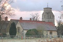
St. Peter's parish church
 Marsh Baldon
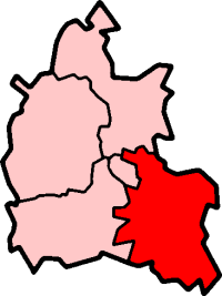
Marsh Baldon shown within OxfordshirePopulation 289 (2001 census)[1] OS grid reference SU5699 Parish Marsh Baldon District South Oxfordshire Shire county Oxfordshire Region South East Country England Sovereign state United Kingdom Post town Oxford Postcode district OX44 Dialling code 01865 Police Thames Valley Fire Oxfordshire Ambulance South Central EU Parliament South East England UK Parliament Henley Website Welcome to Marsh Baldon List of places: UK • England • Oxfordshire Marsh Baldon is village and civil parish about 5 miles (8.0 km) southeast of Oxford in Oxfordshire.
Contents
Parish church
The Church of England parish church of Saint Peter dates from the 12th century. Its 14th century bell tower[2] has a ring of five bells,[3] the oldest of which was cast by John White of Reading[4] in about 1480.[3] Ellis Knight I of Reading[4] cast two more, including the tenor bell, in about 1628.[3] Mears and Stainbank of the Whitechapel Bell Foundry[4] cast another bell in 1902 and finally the treble bell in 1954.[3] There is also a Sanctus bell that was cast in about 1760 by Robert Wells[3] of Aldbourne.[4] The church building was restored in 1890.[2]
Economic and social history
Most of Marsh Baldon's houses and cottages are arranged around the village green, which is an irregular square shape with an area of more than 1.2 acres (0.49 ha).[5] The green is common land that was used for grazing. Until the 20th century the road through Marsh Baldon was gated at both ends of the village to prevent livestock from straying.[6]
It may be that the earliest settlement was clustered around St. Peter's church.[7] The large green north-east of this original settlement would subsequently have been reclaimed from marshland early in the Middle Ages and then surrounded by houses.[7]
Baldon House was built in the 17th century and extended in the 18th century.[8]
School
The parish has a Church of England primary school.[9] It was founded at Toot Baldon in 1771, when Elizabeth Lane left the house and four acres of land at Herbert's Farm for the purpose.[10] The farmhouse accommodated the schoolmaster, the four acres were for a site for the school and an orchard as its endowment.[10] Elizabeth Lane's bequest funded free education for six boys and six girls; other families paid fees for the school to educate their children. By 1866 the school had 56 pupils.[10]
The present building at Marsh Baldon was erected in 1873 and a second classroom was added in 1897.[10] In 1929 the school was reorganised for junior pupils only, with children over 11 years old going to the Church of England school at Dorchester on Thames from then onwards.[10] The number of pupils enrolled in the reorganised school rose from 40 in 1929 to 52 in 1952.[10]
Amenities
 The Seven Stars public house
Marsh Baldon has a public house, the Seven Stars.[11] Marsh Baldon and Toot Baldon share a cricket club.[12]
In the southeast of the parish, next to the boundary with Nuneham Courtenay, are two woods: Old Common and Bluebell Wood. The latter contains Harcourt Arboretum, which is part of the University of Oxford's Botanic Garden.
Gallery
-

Sundial at St Peter's church, 11th or 12th century
-

Porch of St Peter's church, 14th or 15th century
-

Perpendicular Gothic east window of St Peter's church, 15th century
-

Perpendicular Gothic piscina of St Peter's church, 15th century
-

Jacobean pulpit of St Peter's church, 17th century
-

Monumental plaque in St Peter's church to Anna Cawley, 1701
-

Vernacular thatched cottage in Marsh Baldon
-

Vernacular cottages at Marsh Baldon
References
- ^ "Area: Marsh Baldon CP (Parish): Parish Headcounts". Neighbourhood Statistics. Office for National Statistics. http://neighbourhood.statistics.gov.uk/dissemination/LeadTableView.do?a=7&b=798667&c=Marsh+Baldon&d=16&e=15&g=480907&i=1001x1003x1004&o=1&m=0&r=1&s=1268948980359&enc=1&dsFamilyId=779. Retrieved 18 March 2010.
- ^ a b Sherwood & Pevsner, 1974, page 698
- ^ a b c d e "Place: Marsh Baldon S Peter". Dove's Guide for Church Bell Ringers. http://dove.cccbr.org.uk/detail.php?searchString=Marsh+Baldon&numPerPage=10&Submit=Go&searchAmount=%3D&searchMetric=cwt&sortBy=Place&sortDir=Asc&DoveID=MARSH+BALD. Retrieved 16 December 2010.
- ^ a b c d "Bell Founders". Dove's Guide for Church Bell Ringers. http://dove.cccbr.org.uk/founders.php. Retrieved 16 December 2010.
- ^ Rowley, 1978, page 33
- ^ Rowley, 1978, page 35
- ^ a b Rowley, 1978, pages 33, 35
- ^ Sherwood & Pevsner, 1974, page 699
- ^ Marsh Baldon CE Primary School
- ^ a b c d e f Lobel, 1957, pages 30-47
- ^ The Seven Stars
- ^ The Baldons Cricket Club
Sources
- Lobel, Mary D, ed (1957). A History of the County of Oxford: Volume 5: Bullingdon Hundred. Victoria County History. pp. 30–47.
- Rowley, Trevor (1978). Villages in the Landscape. Archaeology in the Field Series. London: J.M. Dent & Sons Ltd. pp. 33, 35. ISBN 0 460 04166 5.
- Sherwood, Jennifer; Pevsner, Nikolaus (1974). Oxfordshire. The Buildings of England. Harmondsworth: Penguin Books. pp. 698–699. ISBN 0 14 071045 0.
External links
 Media related to Marsh Baldon at Wikimedia CommonsCategories:
- Villages in Oxfordshire
- Civil parishes in Oxfordshire
-


Wikimedia Foundation. 2010.