- Marine protected area
-
 Milford Sound, New Zealand is a Strict Marine Reserve (Category Ia) Mitre Peak, the mountain at left, rises 1,692 m (5,551 ft) above the sea.[1]
Marine protected areas, like any protected area, are regions in which human activity has been placed under some restrictions in the interest of conserving the natural environment, it's surrounding waters and the occupant ecosystems, and any cultural or historical resources that may require preservation or management. Marine Protected Areas' boundaries will include some area of ocean, even if it is only a small fraction of the total area of the territory.
Natural or historic marine resources are protected by local, state, territorial, native, regional, or national authorities and may differ substantially from nation to nation. This variation includes different limitations on development, fishing practices, fishing seasons and catch limits, moorings, bans on removing or disrupting marine life of any kind.
In some situations (such as with the Phoenix Islands Protected Area), MPA's also provide revenue for countries, often of equal size as the income that they would have if they were to grant companies permissions to fish.[2]
As of 2010, the world hosted more than 6,800 MPAs, encompassing 1.17% of the world's oceans.[3]
Marine Protected Areas are included on the World Database on Protected Areas (WDPA), which, since 2010 is viewable via Protected Planet, an online interactive search engine hosted by the United Nations Evironment Programme's World Conservation Monitoring Center (UNEP-WCMC).
Contents
Terminology
"MPA" is an umbrella definition for protected areas that include some area of marine landscape and/or biodiversity, but each specific area still falls under the methods of categorisation applied to protected areas which is a way of allotting the management tasks for regions which require will conservation of different scope and detail.
The IUCN defines a Marine Protected Area as;"Any area of the intertidal or subtidal terrain, together with its overlying water and associated flora, fauna, historical and cultural features, which has been reserved by law or other effective means to protect part or all of the enclosed environment."[4]
Alternate Terminology and Importance Economically
An alternate definition from the IUCN of an MPA is," a clearly defined geographical space, recognized, dedicated, and managed through legal or other effective means, to achieve the long term conservation of nature with associated ecosystem services and cultural values." Marine Protected Environments are strong tools ensuring our environment and marine biodiversity. They are not the end. [5] The increasing pressure and stress the oceans are now under, stemming from "the impact of extractive industries, localised pollution, and changes to its chemistry (ocean acidification) resulting from elevated carbon dioxide levels, due to our emissions," are further evidence as to why MPAs may be the ocean's single greatest hope in global protected area action.[6] Action must be taken on a global politically social scale for MPA's to work efficiently. MPA's if enacted rightfully, will bring insurance to fisheries and marine environments globally. Complications will arise, as always in matters of the environment. Conflicts of interest of fisherman, as seen in small Pacific Islands. MPA's in these areas will help economically. MPA's can play a major role economically in Pacific Islands whether its fishing,restoration, or tourism. If MPA's are implemented and managed properly by locals on the coral reefs in these Islands, their economy's will prosper. Most of these island fisherman use harmful ways to catch fish in the reefs. With MPA's protecting these areas through NTA(no take areas), limiting overfishing and false methods, fish and the reefs will flourish as they once did. MPA's are meant to not only protect the marine life but also protect social welfare. With MPA's implemented and managed properly, seen through new technological advances and word spread globally , we will see results like the results seen on Apo Island. They made 1/4 of their reef an MPA allowing fish to breed and thrive jump starting their economy again. This was shown in the film, Resources at Risk: Philippine Coral Reef. [7]
The United States Executive Order 13158 in May 2000 established MPAs, defining them as;
"Any area of the marine environment that has been reserved by federal, state, tribal, territorial, or local laws or regulations to provide lasting protection for part or all of the natural and cultural resources therein."[8]
 The Chagos Archipelago was declared the world's largest Marine Reserve in April 2010 with an area of 250,000 square miles[9]This article is about Marine Protected Areas specifically. For definitions of a Protected Area in general, see Protected area.
Most definitions suggest that in order to be designated a Marine Protected Area, the site must be set aside principally for conservation. Several types of compliant MPAs can be distinguished:
- A totally marine area with no significant terrestrial parts.
- An area containing both marine and terrestrial components, which can vary between two extremes; those that are predominantly maritime with little land (for example, an atoll would have a tiny island with a significant maritime population surrounding it), or a marine area that is mostly terrestrial. In the case of the latter, whether or not it is considered a 'Marine' Protected Area is largely debatable.
- Marine ecosystems that contain land and intertidal (land that is frequently covered by water) components only. For example, a mangrove forest would contain no open sea or ocean marine environment, but its river-like marine ecosystem nevertheless constitutes the definition.
The Convention on Biological Diversity attempted to solve the uncertainty in classifying Marine Protected Areas by defining the broader term of 'Marine and Coastal Protected Area' (MCPA);
"Any defined area within or adjacent to the marine environment, together with its overlying water and associated flora, fauna, historical and cultural features, which has been reserved by legislation or other effective means, including custom, with the effect that its marine and/or coastal biodiversity enjoys a higher level of protection than its surroundings."[10]
Different definitions may be altered by minute differentiating factors, for example, some may need at least some part of the area lies below low tide, while others require only that it be at least near the shoreline. The categories they are then placed into are equally complex, and dictate the management and usage of Marine Protected Areas on a categoric scale differing between whether they can permit recreational and/or extractive uses, or are exclusively reserve for conservation or scientific research. The International Union for Conservation of Nature(IUCN) attempts to encompass these variations by defining seven categories of protected area, based on management objectives and four broad governance types.
Cat IUCN Protected Area Management Categories: Ia Strict Nature Reserve
A Marine Reserve usually connotes 'maximum protection', where all removals of resources are strictly prohibited. In some countries such as Kenya and Belize, Marine Reserves allow for low-risk forms of to sustain local communities. Though this suggests an area of lower protection, these reserves maintain their categorical status which iterates their biological importance.Ib Wilderness Area II National Park
Marine Parks lay a high emphasis on the protection of ecosystems but have been known to allow light human use. A Marine Park may prohibit fishing or extraction of resources of any kind, but could possibly allow recreation. However some Marine Parks, such as those in Tanzania, are zoned and activities such as fishing are only allowed in particularly low risk areas.III Natural Monuments or Features
Established to protect historical sites such as shipwrecks and cultural sites such as aboriginal fishing grounds.IV Habitat/Species Management Area
Established to protect a certain species, to benefit fisheries, rare habitat, as nursing grounds for fish, or to protect entire ecosystems.V Protected Seascape
Limited active management assigned, as with Protected Landscapes.VI Sustainable use of Natural Resources These categories may also encompass the following;
- World Heritage Site (WHS) – an area exhibiting extensive natural or cultural history. Maritime areas are poorly represented, however, with only 31 out of over 800 sites.
- Man and the Biosphere – This UNESCO program promotes "a balanced relationship between humans and the biosphere." Under article 4, biosphere reserves must “encompass a mosaic of ecological systems”, and thus combine terrestrial, coastal, or marine ecosystems. In structure they are similar to Multiple-use MPAs, with a core area ringed by different degrees of protection.[11]
- Ramsar Site – These sites must meet certain criteria for the definition of "Wetland" to become part of a global system. These sites do not necessarily receive protection, but are indexed by importance for later recommendation to an agency that could designate it a protected area.[12]
While 'area' refers to a single contiguous location, terms such as "network", "system", and "region" that group MPAs are not always consistently employed."System" is generally more often used to refer to an individual MPA, whereas "region" is defined by the World Conservation Monitoring Centre as:
"A collection of individual MPAs operating cooperatively, at various spatial scales and with a range of protection levels that are designed to meet objectives that a single reserve cannot achieve."[13]
At the Convention on Biological Diversity 2004, the agency agreed to the use of "network" on a global level, and the use of system on the national and regional level. The global level is to be used as a mechanism to establish regional and local systems but carries no authority or mandate, and all of the work lies within the "system".[14]
A No Take Zone (NTZ), are areas such as New Zealand's marine reserves, where all forms of exploitation are prohibited and severely limits human activities. Generally, a No Take Zone can cover the whole MPA, or specific vulnerable portions that enjoy elevated protection. Related terms include; Specially Protected Area (SPA), Special Area of Conservation (SAC), the United Kingdom's Marine Conservation Zones (MCZ),[15] or Area of Special Conservation (ASC) etc. which each have specific restrictions associated with them.
Management and restrictions
Typical restrictions in MPAs include ones on fishing, oil and gas mining and tourism. Other restrictions may limit the use of ultrasonic devices like SONAR (which may confuse the guidance system of cetaceans), development, construction and the like. Some fishing restrictions include what are called "no-take" zones, which means that no fishing is allowed. Less than 1% of MPAs are no-take in the United States. Ship transit can also be regulated or banned, either as a preventive measure or to avoid direct disturbance to certain species. The degree to which environmental regulations affect shipping varies according to whether MPAs are located in territorial waters, exclusive economic zones, or the high seas. The law of the sea regulates these limits.
For this reason, most MPAs have been located in territorial waters, where enforcement can be ensured. However, MPAs can also be established in a state's exclusive economic zone and in international waters. For example, Italy, France and Monaco in 1999 jointly established a cetacean sanctuary in the Ligurian Sea named the Pelagos Sanctuary for Mediterranean Marine Mammals. This sanctuary includes both national and international waters. Both the CBD and IUCN recommend that a variety of possible management systems be considered when designing a protected area system. They advocate that MPAs be seen as one of many "nodes" in a network of protected areas.[16] The following are the most commonly used individual types of management systems for MPAs;
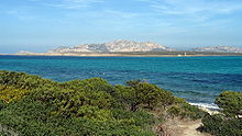 Asinara, Italy is listed by WDPA as both a Marine Reserve and a National Marine Park, and as such could be labelled 'multiple-use'[17]
Seasonal and Temporary Management
Activities, most critically fishing, are restricted seasonally or temporarily to let the area recover. Seasonal limits are put in place to protect fish populations during vital periods like spawning season.Multiple-use
Increasingly, multiple use MPAs are the most common and arguably the most effective type of MPA. These areas employ two or more types, which enables flexibility for the most important sections get the highest protection. A common practice is to make the most critical area a No Take Zone, and surrounding it with areas of lesser protections.Community involvement and related approaches
Community-managed MPAs empower local communities to manage marine resources partially or completely independent of the governmental jurisdictions they inhabit. They are not always officially recognized, depending on the political environment. Empowering communities to manage resources can lower conflict levels and help fisheries recover. This approach can provide direct influence for all involved, including subsistence and commercial fishers, scientists, tourism businesses, youths and others.MPA Networks
“A group of MPAs that interact with one another ecologically and/or socially form a network.” [18] These MPA Networks are intended to connect individuals and MPAs through the ecosystem and promote education and cooperation among various administrations and people with invested interest in the state of the MPA. [19] “MPA networks are, from the perspective of resource users, intended to address both environmental and socio-economic needs, complementary ecological and social goals and designs need greater research and policy support.” [20]. Some communities associated with MPAs in the Philippines connect with one another to share information about MPAs, creating an even larger network through the social communities’ support. [21] Emerging or established MPA networks can be found in Southeast Australia, Belize, the Red Sea, Gulf of Aden, and Mexico. [22]
International efforts
The 17th International Union for Conservation of Nature (IUCN) General Assembly in San Jose, California, the 19th IUCN assembly and the fourth World Parks Congress all proposed to centralise the establishment of protected areas. The World Summit on Sustainable Development in 2002 called for
the establishment of marine protected areas consistent with international laws and based on scientific information, including representative networks by 2012.[23]The Evian agreement, signed by G8 Nations in 2003, agreed to these terms. The Durban Action Plan, developed in 2003, called for regional action and targets to establish a network of protected areas by 2010 within the jurisdiction of regional environmental protocols.It recommended establishing protected areas for 20 to 30% of the world's oceans by the goal date of 2012. The Convention on Biological Diversity considered these recommendations and recommended requiring nations to set up marine parks that are controlled by a central organization before merging them. The United Nations Framework Convention on Climate Change agreed to the terms laid out by the convention, and in 2004, its member nations committed to the following targets;[24]
- By 2006 complete area system gap analysis at national and regional levels.
- By 2008 address the more underrepresented of marine ecosystems in existing national and regional systems of protected areas, taking into account marine ecosystems beyond areas of national jurisdiction in accordance with applicable international laws.
- By 2009 designate the protected areas identified through the gap analysis.
- By 2012 complete the establishment of a comprehensive and ecologically representative national and regional system of Marine Protected Areas.
 Bunaken Marine Park, Indonesia is officially listed as both a Marine Reserve and a National Marine Park.[25]
"The establishment by 2010 of terrestrial and by 2012 for marine areas of comprehensive, effectively managed, and ecologically representative national and regional systems of protected areas that collectively, inter alia through a global network, contribute to achieving the three objectives of the Convention and the 2010 target to significantly reduce the current late of biodiversity loss at the global, regional, national, and sub-national levels and contribute to poverty reduction and the pursuit of sustainable development."[26]
The UN later also endorsed another decision, Decision VII/15, in 2006:
Effective conservation of 10% of each of the world's ecological regions by 2010.
– United Nations Framework Convention on Climate Change Decision VII/15[27]Many countries have established national targets, accompanied by action plans and implementations. The UN Council identified the need for countries to collaborate with each other to establish effective regional conservation plans. A few of these national targets are listed in the table below[28]
Country Plan of Action American Samoa 20% of reefs to be protected by 2010 South Australia 19 Marine Protected Areas by 2010 Bahamas 20% of the marine ecosystem protected for fishery replenishment by 2010.
20% of coastal and marine habitats by 2015.Belize 20% of bioregions. 30% of Coral reefs.
60% of turtle nesting sites.
30% of Manatee distribution.
60% of American crocodile nesting.
80% of Breeding areas.
Chile 10% of marine areas by 2010. National network for organization by 2015. Cuba 22% of land habitat, including: - 15% of the Insular shelf
- 25% of Coral reefs
- 25% of Wetlands
Dominican Republic 20% of Marine and Coastal by 2020. Micronesia 30% of shoreline ecosystems by 2020. Fiji 30% of reefs by 2015. 30% of water managed by Marine Protected Areas by 2020.
Germany 38% of water managed by the Marine Protected network. (no set date) Grenada 25% of nearby marine resources by 2020. Guam 30% of nearby marine ecosystem by 2020. Indonesia 100,000 km2 by 2010. 200,000 km2 by 2020.
Jamaica 20% of marine habitats by 2020. Madagascar 100,000 km2 by 2012. Marshal Islands 30% of nearby marine ecosystem by 2020. New Zealand 20% of marine environment by 2010. North Mariana Islands 30% of nearby marine ecosystem by 2020. Palau 30% of nearby marine ecosystem by 2020. Peru Marine Protected Area system established by 2015. Philippines 10% Fully Protected by 2020. Senegal Creation of MPA network. (no set date) St. Vincent and the Grenadines 20% of marine areas by 2020. Tanzania 10% of marine area by 2010; 20% by 2020. United Kingdom Establish an ecologically coherent network of marine protected areas by 2012. USA – California 29 MPAs covering 18% of state marine area with 243 square kilometres (94 sq mi) at maximum protection. Global status
The Marine Protected Area network is still in its infancy. As of October 2010, the data gathered by the WDPA indicated there were approximately 6,800 MPAs around the world, which embodies 1.17% of global ocean area. The same data also assessed Exclusive Economic Zones (EEZs) – edge of territorial seas to 200 nautical miles out - and found 2.86% of these zones to be protected.[3] Territorial seas – out to 12 nautical miles from a state’s coast – are more highly protected, with 6.3% of these protected.[29]. Marine protected areas is often perceived as a relative term. Most pointedly the term protected, what the area is protected against is often times not specified. Many of the marine protected areas prohibit the use of harmful fishing techniques yet only 0.01% of the ocean's area is designated as a "No Take Zone" [30]. This statistic is deemed as unacceptable with the projected goal lying at 20%-30% [31]of the world's marine environment being designated as a no take area [32]. Several institutions at the local, community, federal, and national levels have taken steps in the implementation of no take area policy in hopes that the 20-30% goal can be reached. The following data gives a regional representation of international status on Marine Protected Areas.[33]
Greater Caribbean
 The Caribbean region; the UNEP–defined region also includes the Gulf of Mexico. This region is encompassed by the Mesoamerican Barrier Reef System proposal, and the Caribbean challenge
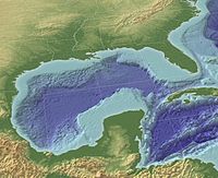 The Gulf of Mexico region (in 3D) is encompassed by the "Islands in the Stream" proposal.
The Greater Caribbean subdivision encompasses an area of about 5,700,000 square kilometres (2,200,000 sq mi) of ocean and 38 very diverse nations. The area includes island countries like the Bahamas and Cuba, and the majority of Central America. The Convention for Protection and Development of the Marine Environment of the Wider Caribbean Region (better known as the Cartagena Convention) was established in 1983, and protocols involving protected areas were ratified in 1990.
As of 2008, there are about 500 MPAs in the region. Coral reefs are the best represented.Two networks are under development, the Mesoamerican Barrier Reef System (a long barrier reef that borders the coast of much of Central America), and the "Islands in the Stream" program (covering the Gulf of Mexico).[34]
Southeast Asia
Southeast Asia is a global epicenter for marine diversity but 12% of coral reefs are in MPAs whereas the rest or at risk of disappearing. The Philippines and Indonesia are two of the major places within Southeast Asia that have Marine Protected Areas. The Philippines have some the world’s best coral reefs and they need them for tourism which is why some of the country is a MPA. Most of the Philippines’ MPAs are established to secure protection for the coral reefs and the sea grass systems. Indonesia has MPAs that are used for tourism as well, since the country is highly reliant on tourism as a main source of income. [35]
The Philippines
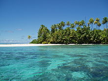
The Philippines boast one of the most biodiversity regions on the entire planet with 464 reef-building coral species but due to overfishing, destructive fishing techniques, and rapid coastal development in recent years, these reefs have suffered a heavy decline in health. As a response, many MPAs have been springing up over the last twenty years with current estimates at about 600 MPAs. However, the majority of these MPAs are poorly (people in the regions either ignore their restrictions or don’t even know of their existence) and as a result are highly ineffective. On the other hand, there are several MPAs in the Philippines that are well known for having an impact on the health of their reefs by enhancing fish biomass, decreasing coral bleaching, and increasing yields in adjacent fisheries. One notable example is the MPA surrounding Apo Island.[36]
Latin America
Latin America in particular considers itself one large MPA system. As of 2008, 0.5% of the Latin American marine environment is protected, mostly through the use of small, multiple-use MPAs.[37]
South Pacific
The South Pacific network ranges from Belize to Chile. Governments in the region adopted the Lima Convention and Action Plan for protected areas for the South Pacific region in 1981; an MPA-specific protocol was ratified in 1989. The Permanent Commission on the Exploitation and Conservation on the Marine Resources of the South Pacific promotes the exchange of studies and information among participants.[37]
The region is currently running one comprehensive cross-national program, the Tropical Eastern Pacific Marine Corridor Network, signed in April 2004. The network covers about 211,000,000 square kilometres (81,000,000 sq mi).[37]
North Pacific
The North Pacific network covers the western coasts of Mexico, Canada, and the U.S. The "Antigua Convention" and an action plan for the north Pacific region were adapted in 2002. There, is however, no protocol; participant nations manage their own national systems.[37] In 2010-2011, the State of California is completing a series of hearings and actions via the state Department of Fish and Game to establish new MPA's. Although highly controversial among fishing circles, the MPA's are going forward with decisions still pending as to where and how large.
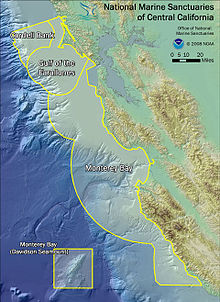 Diagram illustrating the orientation of the 3 marine sanctuaries of Central California: Cordell Bank, Gulf of the Farallones, and Monterey Bay. Davidson Seamount, part of the Monterey Bay sanctuary, is indicated at bottom-right.
United States
In April 2009, the United States established a National System of Marine Protected Areas, which strengthens the protection of U.S. ocean, coastal, and Great Lakes resources. These large-scale MPAs should balance "the interests of conservationists, fishers, and the public." [38] As of 2009, 225 MPAs participated in the national system. Sites agree to work together toward common national and regional conservation goals and priorities. NOAA’s National Marine Protected Area’s Center maintains a comprehensive inventory[39] of all 1,600+ MPAs within the Exclusive Economic Zone of the United States. Most MPAs in the U.S. allow some type of extractive use. Less than 1% of U.S. waters prohibit all extractive activities.[40]
In 1981 the Olympic National Park in Western Washington became a marine protected area.[41] The total protected site area is 3,697 km2 with 173.2 km2 of the area being a marine protected area. [42] The Olympic National park has been chosen to join a national program of marine protected areas nominated by their managing programs. The national system is a mechanism to foster great collaboration among participating MPA sites and programs to enhance stewardship in the waters of the United States.[43] Sites that meet all pertinent criteria are eligible for the national system. There are four entry criteria for existing MPAs to join the national system: "1. Meets the definition of an MPA as defined in the Framework. 2. Has a management plan (can be sitespecific or part of a broader programmatic management plan; must have goals and objectives and call for monitoring or evaluation of those goals and objectives). 3. Contributes to at least one priority conservation objective as listed in the Framework. 4. Cultural heritage MPAs must also conform to criteria for the National Register for Historic Places." [44]
In 1999, California adopted the Marine Life Protection Act, establishing the United States' first state law requiring a comprehensive, science-based network of Marine Protected Areas. To implement the historic law, the state created the Marine Life Protection Act Initiative. A high-level team of policy advisors (the MLPA Blue Ribbon Task Force) as well as stakeholder and scientific advisory groups ensure that the process uses the best science and an unprecedented level of public participation.The MLPA Initiative established a plan to create California's statewide MPA network by 2011 in several steps. The initial (Central Coast) step was successfully completed in September, 2007. The second (North Central Coast) step was completed in 2010. The third (South Coast) and fourth (North Coast) steps are expected to go into effect in 2012.[45]
Europe
The Natura 2000 ecological network of protected areas in the territory of the European Union including a wide range of MPA in the North Atlantic, the Mediterranean Sea and the Baltic Sea. The member states have to define NATURA 2000 areas at sea in their Exclusive Economic Zone.
Two assessments, conducted thirty years apart, of three Mediterranean MPAs demonstrate that proper protection allows commercially valuable and slow-growing red coral (Corallium rubrum) to produce large colonies in shallow water of less than 50 metres (160 ft). Shallow-water colonies outside these decades-old MPAs are typically very small. The MPAs are Banyuls, Carry-le-Rouet and Scandola, off the island of Corsica.[46]
Notable marine protected areas
- The Bowie Seamount on the Coast of British Columbia, Canada.
- The Great Barrier Reef in Queensland, Australia.
- The Ligurian Sea Cetacean Sanctuary in the seas of Italy, Monaco and France
- The Dry Tortugas in the Florida Keys, USA.
- The Papahānaumokuākea Marine National Monument in Hawaii.
- The Phoenix Islands Protected Area, Kiribati[47]
- The Channel Islands Marine Protected Areas in California, USA[48]
- D Smith and KA Miller. (2003). "Safe Harbors for our Future: An Overview of Marine Protected Areas.". In: SF Norton (ed). Diving for Science...2003. Proceedings of the American Academy of Underwater Sciences (22nd Annual Scientific Diving Symposium). http://archive.rubicon-foundation.org/4759. Retrieved 2008-08-13.
Effectiveness
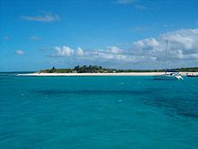 The Prickly Pear Cays are a marine protected area. They're about six miles from Road Bay, Anguilla, in the Leeward Islands of the Caribbean.
Managers and scientists use geographic information systems and remote sensing to map and analyze MPAs. NOAA Coastal Services Center compiled an "Inventory of GIS-Based Decision-Support Tools for MPAs." The report focuses on GIS tools with the highest utility for MPA processes.[40] Remote sensing uses advances in aerial photography image capture, satellite imagery, acoustic data, and radar imagery.
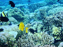
MPAs have also been recognized as an effective tool to maintain localized fish populations. The general concept is to create an area where the local populations of sea creatures can thrive and create a localized over population. When this over population occurs, the extra creatures will expand into the surrounding areas, know as spillover. [49] This, in turn, helps support the local fisheries and the areas surrounding the MPA, while maintaining a healthy population. Such uses of the MPA have been seen in many areas around the world, but most commonly in very densely population areas like coral reefs.
Marine Protected Areas are an especially important management tool for coral reef systems worldwide. Over the past two centuries, coral reef systems have been in great decline due to overfishing and pollution. Currently, 30% of the world’s reefs are already severely damaged, and approximately 60% of the reefs will be lost by 2030 if actions are not taken to recover and protect them. [50] Coral Reef Systems are also facing extinction due to changes in the chemistry of the ocean and the rising ocean temperatures, both caused by global climate change. Marine Protected Areas are currently the best tool for managing the impacts to coral reefs, with “No Take Zones” acting as the most effective form of management.[51] Though Marine Protected Areas and No-Take Zones cannot stop the effects of global climate change, these management tools can protect the coral reefs from human damage and exploitation, allowing the reefs and the species they house to build resilience to recover to the changes brought by global climate change more effectively and rapidly.
Spillover Effect and other unexpected results
The "Spillover Effect" occurs when the fish stocks with in an MPA are replenished and spill over into the non-protected areas. One clear example of this is at Goad Island Bay in New Zealand. As one of the oldest no-take reserves in the world (it was established in 1977), research gathered at Goat Bay has overwhelmingly shown evidence of the spill over effect. In fact, "Spill over and larval export--the drifting of millions of eggs and larvae beyond the Reserve--have become central concepts of marine conservation" (National Geographic, 2007). This positively impacts commercial fishermen in surrounding areas[52].
Another unexpected result of MPAs is their impact on predatory marine species. In general, studies show that bio-diversity increases in MPAs. However, sometimes conditions within a reserve favor an increase in predator populations. When this occurs, prey populations decrease. One study showed that in 21 out of 39 cases "tropic cascades," caused a decrease in herbivores, which led to an increase in the quantity of plant life. (This occurred in the Malindi Kisite and Watamu Marian National Parks in Kenya; the Leigh Marine Reserve in New Zealand; and Brackett's Landing Conservation Area in the U.S.). [53]
Criteria
Both CBD and IUCN have criteria for setting up and maintaining MPA networks, which emphasize 4 factors:[54]:
- Adequacy—ensuring that the sites have the size, shape, and distribution to ensure the success of selected species.
- Representability—protection for all of the local environment's biological processes
- Resilience—the resistance of the system to natural disaster, such as a tsunami or flood.
- Connectivity—maintaining population links across nearby MPAs.
Misconceptions
There are some misconceptions on what an MPA really does and who controls them. One misconception is that all MPAs are no-take or no-fishing areas. The reality is that less than 1 percent of US waters are no-take areas. MPAs can be used for a lot of different uses such as consumption fishing, diving, and other activities. Another misconception is that most MPAs are federally managed. The reality is that MPAs are managed unter a very complex system consisting of hundreds of laws and jurisdictions. They can be managed in state, commonwealth, territory, and tribal waters. A third misconception is that there is a federal mandate to dedicate a set percentage of ocean to MPAs. In reality there is no set percentage goal written in law. The mandate simply calls for an evaluation of current MPAs and create a public resource on current MPAs in existence. [55]
Criticism
Some existing and proposed MPAs have been criticized by local indigenous populations, and their supporters, as impinging on land usage rights. One example of this is the proposed Chagos Protected Area in the Chagos Islands, contested by Chagossians deported from their homeland in 1965 by the British in the creation of the British Indian Ocean Territory (BIOT). According to Wikileaks CableGate documents,[56] the UK proposed that the BIOT become a "marine reserve" with the aim of preventing the former inhabitants from returning to their lands and to protect the joint United Kingdom and United States military base on Diego Garcia Island.
One alternative to imposing MPAs on an indigenous population is through the use of Indigenous Protected Areas, such as those in Australia.
Recent research
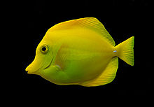
In 2010, a group of scientists reported that fish larvae can drift on ocean currents and reseed fish stocks at a distant location. This finding demonstrates, for the first time, what scientists have long suspected but have never proven, that fish populations can be connected to distant populations through the process of larval drift.[57]
The fish they chose to investigate was the yellow tang, because when a larva of this fish find a suitable reef it stays in the general area for the rest of its life. Thus, it is only as drifting larvae that the fish can migrate significant distances from where they are born.[58] The tropical yellow tang is much sought after by the aquarium trade. By the late 1990s, their stocks were collapsing, so in an attempt to save them nine MPAs were established off the coast of Hawaii. Now, through the process of larval drift, fish from the MPAs are establishing themselves in different locations, and the fishery is recovering.[58] "We've clearly shown that fish larvae that were spawned inside marine reserves can drift with currents and replenish fished areas long distances away," said one of the authors, the marine biologist Mark Hixon. "This is a direct observation, not just a model, that successful marine reserves can sustain fisheries beyond their borders."[58]
See also
- Marine park
- Marine reserve
- Marine Spatial Planning
- Mediterranean Science Commission; proposed the creation of 7 marine protected areas ("peace parcs")[59][60]
- National Marine Protected Areas Initiative
- Protected area
- Special Area of Conservation
- Special Protection Area
- Specially Protected Areas of Mediterranean Importance
- United States National Marine Sanctuary
References
- ^ Milford Sound Marine Reserve
- ^ National Geographic Magazine, January 2011
- ^ a b Global Ocean Protection: Present Status and Future Possibilities
- ^ IUCN: Marine Protected Areas, Why have them?
- ^ http://www.iucn.org/about/union/commissions/wcpa/wcpa_puball/wcpa_pubsubject/wcpa_marinepub/?2135/Towards-Networks-of-Marine-Protected-Areas-The-MPA-Plan-of-Action-for-IUCNs-World-Commission-on-Protected-Areas
- ^ Laffoley, D. d’A., (ed.) 2008. Towards Networks of Marine Protected Areas. The MPA Plan of Action for IUCN’s World Commission on Protected Areas. IUCN WCPA, Gland, Switzerland. 28 pp.
- ^ Christie, P. and A.T. White. 2007. Best practices for improved governance of coral reef Marine Protected Areas. Coral Reefs 26:1047-1056.
- ^ Nomination of Existing Marine Protected Areas to the National System of Marine Protected Areas and Updates to the List of National System Marine Protected Areas
- ^ Foreign and Commonwealth Office, New Protection for Marine Life, April, 2010
- ^ Areas of Biodiversity Importance: Marine Protected Areas, 2010
- ^ UNESCO, Man and the Biosphere Programme
- ^ Information Sheet on Ramsar Wetlands
- ^ WDPA: Establishing Resilient Marine Protected Area Networks — Making It Happen, 2008
- ^ UNEP: Marine Protected Areas and the Concept of Fisheries Refugia, 2006/
- ^ Marine Conservation Zones
- ^ UNEP-WCMC: Marine Protected Area Networks
- ^ Asinara Natural Marine Reserve
- ^ Christie, P., and A. T. White. "Best Practices for Improved Governance of Coral Reef Marine Protected Areas." Coral Reefs 26.4 (2007): 1047-056. Print.
- ^ Christie, P., and A. T. White. "Best Practices for Improved Governance of Coral Reef Marine Protected Areas." Coral Reefs 26.4 (2007): 1047-056. Print.
- ^ Christie, P., and A. T. White. "Best Practices for Improved Governance of Coral Reef Marine Protected Areas." Coral Reefs 26.4 (2007): 1047-056. Print.
- ^ Lowry, G. K., A. T. White, and P. Christie. "Scaling Up to Networks of Marine Protected Areas in the Philippines: Biophysical, Legal, Institutional, and Social Considerations." Coastal Management 37.3 (2009): 274-90. Print.
- ^ Christie, P., and A. T. White. "Best Practices for Improved Governance of Coral Reef Marine Protected Areas." Coral Reefs 26.4 (2007): 1047-056. Print.
- ^ Wells et al. 2008, p. 13
- ^ UNWP-WCMC National and Regional Networks of Marine Protected Areas: A Review of Progress
- ^ Bunaken Marine Park
- ^ United Nations Framework Convention on Climate Change, Decision VII/28
- ^ United Nations Framework Convention on Climate Change, Decision VII/15
- ^ Wells et al. 2008, p. 15
- ^ UN (2010) Millennium Development Goals Report – Addendum
- ^ Christie, Patrick, and A.T White. "Best practices for improved governance of coral reef marine protected areas." (2007): 1048-1056. Print.
- ^ Halpern, B. 2003. The impact of marine reserves: do reserves work and does reserve size matter? Ecological Applications 13: S117- S137.
- ^ http://www.wiomsa.org/mpatoolkit/Themesheets/I1_No_take_areas.pdf
- ^ Wood et al. Assessing Progress Towards Global Marine Protection Targets: Shortfalls in Information and Action, 2008, Oryx 42:340–351
- ^ Wells et al. 2008, p. 33
- ^ Christie, P. and A.T. White. 2007. Best practices for improved governance of coral reef marine protected areas. Coral Reefs 26:1047-1056.
- ^ http://www.reefbase.org/key_topics/pdf/Philippines%20mpa.pdf
- ^ a b c d Wells et al. 2008
- ^ Christie, P., and A. T. White. "Best Practices for Improved Governance of Coral Reef Marine Protected Areas." Coral Reefs 26.4 (2007): 1047-056. Print.
- ^ MPA Inventory
- ^ a b Marine Protected Areas Government Website
- ^ http://www.mpaglobal.org/index.php?action=showMain&site_code=2579
- ^ http://www.mpaglobal.org/index.php?action=showMain&site_code=2579
- ^ http://www.thefederalregister.com/d.p/2010-01-07-E9-31406
- ^ http://www.thefederalregister.com/d.p/2010-01-07-E9-31406
- ^ Department of Fish and Game. "http://www.dfg.ca.gov/mlpa/
- ^ "Marine Protected Areas Conserve Mediterranean Red Coral". Science Daily. May 11, 2010. http://www.sciencedaily.com/releases/2010/05/100511102115.htm. Retrieved June 11, 2010.
- ^ Conservation International – World’s Largest Marine Protected Area Created in Pacific Ocean
- ^ Smith & Miller 2003
- ^ http://innri.unuftp.is/pdf/Marine%20Protected%20Areas.pdf
- ^ Pandolfi, J.M.; et al. (2003). "Global trajectories of long-term decline of coral reef ecosystems". Science (301): 955–958. doi:10.1126/science.1085706.
- ^ Hughes, T.P.; et al. (2003). "Climate change, human impacts, and the resilience of coral reefs.". Science (301): 929–933. doi:10.1126/science.1085046.
- ^ Warne, Kennedy. "Saving the Sea's Bounty." National Geographic. April 2007.
- ^ MPA News, Vol. 6 No. 1, July 2004
- ^ Wells et al. 2008, p. 17 The International Union for Conservation of Nature defines a protected area as:
"A clearly defined geographical space, recognized, dedicated, and managed, through legal or effective means, to achieve the long-term conservation of nature with associated ecosystem service and cultural value."
- ^ http://mpa.gov/pdf/helpful-resources/factsheets/mpamisconceptions2.pdf
- ^ "WikiLeaks reveals U.S., British use marine reserves as tool of imperialism". Embassy London. 2009-05-15. http://www.indybay.org/newsitems/2010/12/23/18667425.php. Retrieved 2010-12-24.
- ^ a b Christie MR, Tissot BN, Albins MA, Beets3 JP, Jia Y, Ortiz DL, Thompson SE, Hixon MA (2010) Larval Connectivity in an Effective Network of Marine Protected Areas PLoS ONE, 5(12) doi:10.1371/journal.pone.0015715
- ^ a b c Drifting Fish Larvae Allow Marine Reserves to Rebuild Fisheries ScienceDaily , 26 December 2010.
- ^ [http://magazine.nationalgeographic.nl/2011/02/22/in-het-kielzog-van-jacques-cousteau/ 7 peace parcs proposed by CIESM
- ^ CIESM webpage
Citations
- Wells, Sue; Sheppard, V.; van Lavieren, H.; Barnard, N.; Kershaw, F.; Corrigan, C.; Teleki, K.; Stock, P. et al. (2008). "National and Regional Networks of Marine Protected Areas:A Review of Progress". Master Evaluation for the UN Effort. World Conservation Monitoring Centre The Americas. http://ia700103.us.archive.org/6/items/nationalregional08well/nationalregional08well.pdf. Retrieved 2009-03-18.
- D Smith and KA Miller. (2003). "Safe Harbors for our Future: An Overview of Marine Protected Areas.". In: SF Norton (ed). Diving for Science...2003. Proceedings of the American Academy of Underwater Sciences (22nd Annual Scientific Diving Symposium). http://archive.rubicon-foundation.org/4759. Retrieved 2008-08-13.
- Australian Government, Department of the Environment and Water Resources (May 2007) (PDF), Growing up strong: The first 10 years of Indigenous Protected Areas in Australia, Canberra: Australian Government, ISBN 978 0 642 55352 1, http://www.environment.gov.au/indigenous/publications/pubs/ipa-growing-up-strong.pdf, retrieved 2008-05-08
Further reading
- Fabio Spadi (2000), "Navigation in Marine Protected Areas: National and International Law", [1], Ocean Development and International Law 31: 285–302.
- Markus J. Kachel (2008), Particularly Sensitive Sea Areas, Hamburg Studies on Maritime Affairs[2]
- Moustakas, A. & I. Karakassis. How diverse is aquatic biodiversity research?, Aquatic Ecology, 39, 367–375
- Moustakas, A. & I. Karakassis (in press). A geographic analysis of the published aquatic biodiversity research in relation to the ecological footprint of the country where the work was done. Stochastic Environmental Research and Risk Assessment, Doi: 10.1007/s00477-008-0254-2.
External links
- World Database on Marine Protected Areas – by UNEP-WCMC
- Protect Planet Ocean – Marine Protected Areas site
- A-Z of Areas of Biodiversity Importance: Marine Protected Areas
- MPA News: monthly news and analysis on marine protected areas worldwide
- Microdocs – 'The Short Attention Span Science Theater on Ecological Sustainability'
- CetaceanHabitat.org – Cetacean habitat directory for MPAs, national and international sanctuaries
- WhyFiles.org – Huge Pacific reserve formed in Hawaii
- WWF: An Overview of Marine Protected Areas in the UK
- Misconceptions concerning MPAs (NOAA)
- [3] – New Research shows massive increase in biomass and diversity in what has been called the best MPA in the world.
- Cellular Automata Model of an MPA Fishery Wolfram Demonstrations Project — requires CDF player (free)
Categories:- Environment treaties
- Oceanography
- Fisheries science
- Marine reserves
- Marine conservation


Wikimedia Foundation. 2010.