- Malviya Bridge
-
Malviya Bridge Crosses Ganges Locale Varanasi Total length ? Construction end 1887 Coordinates 25°19′21″N 83°02′04″E / 25.322382°N 83.034582°E Malviya Bridge, inaugurated in 1887 (originally called The Dufferin Bridge) is a a double decker bridge over the Ganges at Varanasi. It carries rail track on lower deck and road on the upper deck. It is one of the major bridges on the Ganges and carries the Grand Trunk Road across the river. It has 7 spans of 350 ft and 9 spans of 110 ft long and it was the first bridge of its type constructed in the Indian sub-continent by the engineers of Oudh and Rohilkhand Railway Company (O&R Railway).[1] The Bridge was renamed as Malviya Bridge in 1948 after Madan Mohan Malaviya. As the bridge is near Rajghat, it is also locally known as Rajghat bridge.
In fiction
Name of the bridge in Rudyard Kipling's story The Bridge Builders is Kashi (Same as the name of the city of the Dufferin Bridge). Dufferin Bridge's opening ceremony was delayed due to floods and the Kashi bridge in the story also faces similar problems due to flooding just before it was opened to public.[2]
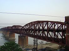 Malviya Bridge
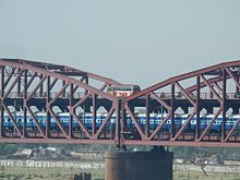 Train passing through the lower deck
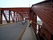 Upper deck of the Malviya Bridge
See also
- List of longest bridges in the world
- List of longest bridges above water in India
References
- ^ Bridges: The Spectacular Feat of Indian Engineering By R.R.Bhandari http://irsme.nic.in/files/mmfiles/BRIDGES_RRB.pdf
- ^ http://www.kipling.org.uk/rg_bridgebuilders1.htm
Coordinates: 25°19′21″N 83°02′04″E / 25.322382°N 83.034582°E
Hydrology of Uttar Pradesh Rivers Main riversNorth flowingSouth flowingLakes Dams/ Barrages Bridges Malviya Bridge • Shahi Bridge, JaunpurRelated topics Hydrology of
surrounding areasUttarakhand • Nepal • Bihar • Jharkhand • Madhya PradeshCategories:- Varanasi
- Bridges in Uttar Pradesh
- Bridges over the Ganges
- Bridges completed in 1887


Wikimedia Foundation. 2010.