- Malvern Hanley Road railway station
-
Malvern Hanley Road 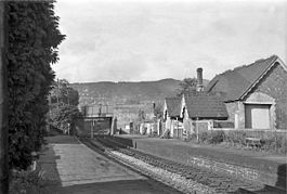
The station in 1951 Location Place Malvern Area Worcestershire Operations Original company Midland Railway Post-grouping London, Midland and Scottish Railway History 1 July 1862 Station opens as Malvern Wells (MR) 2 March 1951 renamed Malvern Hanley Road 1 December 1952 Station closes[1] Disused railway stations in the United Kingdom Closed railway stations in Britain
A B C D–F G H–J K–L M–O P–R S T–V W–ZMalvern Hanley Road railway station was a station on the Midland Railway between Great Malvern and Evesham. For most of its existence it was known on timetables as Malvern Wells MR to distinguish it from the nearby Great Western Railway Malvern Wells. It was renamed in 1951 only to close a year later.
References
- ^ Butt, R.V.J., (1995) The Directory of Railway Stations, Yeovil: Patrick Stephens
Preceding station Disused railways Following station Great Malvern
Line closedTewkesbury and Malvern Railway
Midland RailwayUpton-on-Severn
Line and station closedExternal links
Transport in Worcestershire Road Motorways A-Roads Service Stations Other Rail Main lines Closed lines Stations Closed stations Astwood Bank • Aston-under-Hill • Beckford • Bengeworth • Foley Park Halt • Hinton • Littleton and Badsey • Malvern Wells • Ripple • Upton-on-SevernHeritage stations Other Buses Routes List of bus routes in Worcestershire • Worcestershire bus route 144 • West Midlands Bristol Road bus corridorCompanies Other Bus transport in BromsgroveWaterways Rivers Canals Other Footpaths Long-distance footpaths Cycle Paths Closed railway stations in Worcestershire Tenbury and Bewdley Railway Wyre Forest · Newnham Bridge · Easton CourtWorcester, Bromyard and Leominster Railway Suckley · Knightwick · Leigh CourtWorcester and Hereford Railway Tewkesbury and Malvern Railway Severn Valley Railway Rifle Range Halt · Foley Park Halt · Burlish Halt · Stourport-on-SevernOxford, Worcester and Wolverhampton Railway Cutnall Green Halt · Stoke Works · Fernhill Heath · Astwood Halt · Norton Junction Halt · Stoulton · Wyre Halt · Fladbury · Littleton and BadseyBirmingham and Gloucester Railway Cofton · Blackwell · Stoke Works (B&G) · Dodderhill · Dunhampstead · Oddingley · Bredicot · Spetchley · Norton (B&G) · Abbot's Wood Junction · Wadborough · Pirton · Besford · Defford · Eckington · BredonGloucester Loop Line Honeybourne Line BroadwayCategories:- Disused railway stations in Worcestershire
- Malvern, Worcestershire
- Former Midland Railway stations
- Railway stations opened in 1862
- Railway stations closed in 1952
- West Midlands (region) railway station stubs

Wikimedia Foundation. 2010.