- Majdal Yaba
-
Majdal Yaba 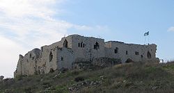
The Majdal Tower Fortress on the former site of Majdal Yaba, 2008
 Majdal Yaba
Arabic مجدل يابا Name Meaning "Tower of [our] Father" or "Tower of Yafa" and later "Tower of Sadiq" Also Spelled Majdal al-Sadiq, Majdal Yafa District Ramla Coordinates 32°04′51.04″N 34°57′24.97″E / 32.0808444°N 34.9569361°ECoordinates: 32°04′51.04″N 34°57′24.97″E / 32.0808444°N 34.9569361°E Population 1,520 (1945) Area 26,332 dunums 26.3 km²
Date of depopulation July 10, 1948[1] Cause(s) of depopulation Military assault by Yishuv forces Current localities Rosh HaAyin, Givat HaShlosha, Nahshonim,[2] Migdal Afek[3] Majdal Yaba (Arabic: مجدل يابا) was a Palestinian Arab village located 18.5 kilometres (11.5 mi) northeast of Ramla and 4 kilometres (2.5 mi) east of Jaffa. A walled city stood at the same site as early as 3000 BCE, and Majdal Yaba is first mentioned by the name Aphek in Egyptian Execration texts dating to the 19th century BCE. In the Bible's Old Testament,[where?] Aphek is described as a city conquered from the Canaanites by the Israelites, who then lost it to the Philistines. It is also mentioned in extrabiblical Babylonian and Assyrian texts as a Philistine stronghold. Under Roman rule, the city was known as Antipatris and the Crusaders, who built a fort there, renamed it Mirabel. During the Islamic period it became known as Majdal Yaba. For a short time under Ottoman rule, its name was changed from Majdal Yaba to Majdal Sadiq and then back again.
Incorporated into British Mandate Palestine in 1922, Majdal Yaba was captured by Israeli forces during the 1948 Arab-Israeli war on July 12, 1948. The town was depopulated as a result of the military assault. The number of refugees from Majdal Yaba was estimated at 1,763 in 1948,[4] and they and their descendants were estimated to number over 10,000 in 1998.[4] The Israeli locality of Rosh HaAyin was established on the village lands in 1950, followed by the moshav of Giv'at HaShlosha in 1953.
Contents
History
Antiquity
Majdal Yaba stood on the site of a walled city in 3000 BCE,[5] and is first mentioned as Aphek in the Ancient Egyptian Execration texts of the 19th century BCE, as well as the 15th century topographical list of Thutmose III.[6] According to biblical tradition, the Israelites under Joshua conquered the city from the Canaanites who had established a monumental palace there. With the Philistines advancing toward the city, the Israelites fled towards the hills of Samaria, and Aphek became the northernmost locality in Philistia. The Philistine army assembled in Aphek for two major battles against the Israelites, including the slaughter of Saul and Jonathan on Mount Gilboa and the capture of the Ark of the Covenant (1066 BCE) (1 Samuel 4:1-12). From then on, the city is not mentioned in the Bible, but the Assyrians and the Babylonians mention it as a stronghold in the 7th century BCE.[5]
King Herod, who ruled the region on behalf of the Roman Empire between 37-4 BCE, renamed the city Antipatris to commemorate his father Antipater, choosing the site because it was in the "loveliest of plains... with an abundance of rivers and trees." Antipatris became a major crossroads between the principal port city of Jaffa and Jerusalem. Saint Paul spent a night there when he was brought from Jerusalem to Caesarea (Acts 23:31). The city was devastated during the southern battles of the First Jewish-Roman War from 66-70 CE and did not recover until the 2nd century CE, but in 363 an earthquake leveled the city.[7]
Rashidun, Umayyad, Abbasid, Fatimid Rule
On April 637 CE, and after a siege of four months, Byzantine Patriarch of Jerusalem Sophronius offered to surrender the city of Jerusalem and pay a jizya, Caliph Umar traveled to Jerusalem in person to receive the submission of the city. Following the Caliph's instructions, Yazid ibn Abi Sufyan proceeded to Caesarea, and once again laid siege to the port city, He must have passed via Majdal Yaba in his way.[8]
On April 27, 750 CE, the Abbasid Abdullah Ibn Ali, Abu Al-Abbas As-Saffah's uncle, marched to Antipatris (Abu Futrus), on June 25, 750 CE Abdullah Ibn Ali invited 80 Umayyad's to (Abu-Futrus) with fair promises . Then, apparently aroused suddenly to revenge and killed them all.[9]
On 5 April 885 AD, at the banks of Auja River, Abul Abbas Ibn Al-Muwaffaq, later known as Abbasid Caliph Al-Mu'tadid, fought at the battle of Tawahin (The Mills) with Khumarawaih ibn Ahmad ibn Tulun, Ibn Al-Muwaffaq first won this battle, Khumaruwaih fled to Egypt. Ibn Al-Muwaffaq army later lost then he fled as well to Damascus.[9]
On 975 AD, The Fatimid Caliph of Egypt Al-'Aziz concquered and took prisoner Aftakin the Turkish General in Hamdanid service with his army on the eastern bank of Auja River opposite the ruined castle of Majdal Yaba.[9]
Crusader, Ayyubid and Mamluk rule
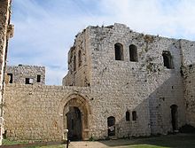 Ruins of the Mirabel fortress
The Crusaders conquered the Levant from the Arab Muslims in 1099, and built a fortress on the site of Majdal Yaba in 1152, naming it Mirabel. The fort was held against Baldwin of Ibelin by Manasses of Hierges, but eventually fell to Baldwin who ruled it as an independent lordship of the Kingdom of Jerusalem from 1162 to 1171.[10] In 1166, lands belonging to the fortress and the harvest of its fields were given to the Church of St. John the Baptist in Nablus.[11]
The tyranny of a crusader lord in Majdal Yaba near Nablus was reported[by whom?] in 1156 CE; he imposed excessive taxs on Muslims, and required Muslims to pay four times as much tax as Christians nearby. The inhabitants of eight villages left their homes in 1156 AC and migrated to Damascus, where they founded "Al-Salahiah" suburb.
In 1177, the Muslim Ayyubids under Saladin marched their army from south of Palestine northwards past Ascalon to the Castle of Mirabel which was being used to defend the road from Jaffa to Jerusalem.[12] In July 1187, Saladin's younger brother, al-Adil I, conquered Mirabel, but did not destroy the castle fortress.[10] According to E.G. Rey there existed among the ruins, 'the remains of a fine church of the 12th century', a claim repeated by T. A. Archer.[13] Chronicler Baha ad-Din ibn Shaddad recorded that in 1191-92, Saladin used the castle fortress as a base for carrying out raids against the Crusaders, although he camped outside of it. However, Saladin gave orders to dismantle the walls of Mirabel after his defeat at the battle of Arsuf.[14]
While under Ayyubid rule in 1226, Arab geographer Yaqut al-Hamawi mentions it as Majdal Yafa or "Tower of Jaffa", probably due to its proximity to the city of Jaffa. He says it was a village with a "formidable fort".[15]
June 1240 CE marked the arrival of the English crusade led by Richard of Cornwall, brother of the King Henry III of England and brother-in-law of Emperor Frederick II. As-Salih Ayyub, King of Egypt, offered Richard of Cornwall a new treaty to be complementary to the earlier treaty held with Theobald IV, Count of Champagne, France. His offer this time included his readiness to recognize the legitimacy of the concessions made by his uncle and opponent As-Salih Ismail, King of Damascus, to the Crusaders, so that the Galilee, and Jaffa and Ashkelon, and all of the city of Jerusalem, including Bethlehem and Majdal Yaba, in addition to Tiberias, Safed, and Belvoir Castle and Al-Tur Castle, were all included in the Kingdom of Jerusalem.[16]
In 1266, after the fall of Jaffa to the Mamluks, Sultan Baibars sent chiefs from Deir Ghassaneh to protect Majdal Yaba's tower.[17] In the late 13th century, the castle fortress at Majdal Yafa was abandoned.[10]
Ottoman rule
 Majdal Yaba during French Invasion of 1799
Majdal Yaba was apparently repopulated when Palestine was incorporated into the Ottoman Empire in the early 16th century, and by 1596, it was a small village in the nahiya ("subdistrict") of Jabal Qubal, part of Sanjak Nablus. It paid taxes on wheat, barley, beehives and goats. The population consisted of 8 Muslim families.[18] The castle fortress in Majdal Yaba that was abandoned in the 13th century, was rebuilt in 18th to 19th centuries.[10]
On March 3, 1799, General Kleber, Commander in Chief of the invading French forces, received the order to push detachments after having taken up position to the south of the river Nahar-al-Ougeh, to watch enemy movements, and to prepare for the army to march to Acre. He instructed General Damas (Lannes), on March 6, to undertake a reconnaissance in the mountains inhabited by the Naplousains, who seemed to be hostile. Turks were firing from behind rocks and down precipices. The small column was obliged to retreat with heavy losses where sixty Franks were killed and more than double the number wonded, and Damas's arm was broken.[19][20]
 The tomb of Sheikh Muhammad Al-Sadiq, 2007
In the 19th century, the village was named Majdal al-Sadiq after Sheikh Muhammad al-Sadiq al-Jamma'ini, the chief of the village who hailed from the prominent Rayyan clan. The Rayyan were a branch of the Bedouin Bani Ghazi tribe that emigrated to Palestine from Jordan in the 17th century.[21] According to Eli Smith, in 1843, the fortress (known as the "Rayyan Fortress") in the village was in ruins.[22]
In Thursday, November 7, 1850 James Finn future British Consul to Jerusalem and Palestine, visited the village and found it and the castle in a very dilapidated condition, he met Sheikh Al Sadiq family, and slept in the castle for a night, he surveyed the church attached to the castle and saw the Greek inscription upon the lintel signifying "Martyr Memorial Church of the Holy Herald,[23]
When Edward Robinson visited in 1852, he reported that the fortress had been rebuilt and also served as a palace for the ruling sheikh. Sheikh al-Sadiq, however, had been banished by the Ottomans.[22] In the 1850s, the Rayyan controlled 22-25 villages in the nahiya of Jamma'in West in Sanjak Nablus,[21] with Majdal Yaba being their main village, where they maintained a fortress and manor.[24] During this time, however, they were embroiled in war with their rival clan, the Qasim — who controlled the Jamma'in East area and also belonged to the Bani Ghazi tribe.[21][24]
In 1859, Sulayman Rayyan was in control of Majdal Yaba,[21] and by 1860 the Rayyan clan had lost all of their influence in the sanjak after they were defeated by the Qasims.[24] The Rayyan continued to live in and rule Majdal Yaba, but the village ceased to be a center of power.[15] According to the Survey of Western Palestine, the Rayyan were "ruined by the Turkish Government."[25] Members of the survey who visited in 1873 reported a large building of "massive masonry", probably a former church, with a side door inscribed in Greek "Memorial of Saint Cerycus".[26]
In 1888, a school was founded in Majdal Yaba.[15]
British Mandate period
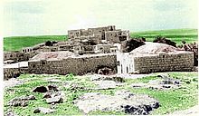 Majdal Yaba before Destruction 1948
Majdal Yaba was incorporated into the British Mandate of Palestine in 1922. The layout of the village resembled a parallelogram and its houses were built close together, being only separated by narrow alleys. They were built of mud and straw or stone and cement. Each neighborhood was inhabited by a single hamula ("clan") and contained a diwan for public meetings and receiving guests.[15] The Rayyan family had still not recovered by the beginning of the Mandate Period; it was known to be impovrished, as was the Qasim family. "Dar az-zalimin kharab [the home of the oppressors is ruined]," said peasants when they passed by their kursis.[27] In 1935, a mosque was built in Majdal Yaba and the Ottoman-built school had reopened in 1920, enrolling 147 students in the mid-1940s. There was also a clinic in the village. Agriculture was the basis of the economy, with farmers planting wheat, corn, barley, vegetables, and sesame. They also tended fruit orchards, particularly citrus. Artesian wells irrigated the fields.[15]
1948 War and aftermath
 Vandalized remaining tomb in Majdal Yaba's cemetery
Majdal Yaba was in the territory allotted to the Arab state under the 1947 UN Partition Plan.[28] However, it was occupied by the Second Battalion of the Alexandroni Brigade on July 12, 1948 in Operation Danny, after wresting it from the Iraqi Army who were defending the village during the 1948 Arab-Israeli War. The nearby village of Ras al-Ein, deserted in the 1920s, was also captured. The New York Times reported that the situation of the surrounded Iraqi troops was "hopeless".[29] The capture of Majdal Yaba also led to the control of the hills lying to the north of the operation zone and the springs of the al-Auja river. On August 28, 1948 The Iraqi forces attempted to recapture the village, but were asked to abandon the operation[30]
The Israeli town of Rosh HaAyin — which today is a city — was built on village lands in 1950, and in 1953, the Jewish moshav of Giv'at HaShlosha was established on village lands. According to Palestinian historian Walid Khalidi, the Rayyan Fortress still "crowns the site" in addition to the tomb of Sheikh Muhammad Al-Sadiq, and a part of the village cemetery still remains. The fortress is "slowly crumbling" and the dome of the tomb is severely cracked.[31]
Demographics
 Families prior to 1948
According to Ottomans records, Majdal Yaba had a population of 44 in 1596.[18] In a 1922 survey by the British Mandate there 796 people living in the village,[4] rising to 966 in a 1931 census.[31] Sami Hadawi recorded a population of 1,520 inhabitants in his 1945 land and population survey.[32] In 1948, it had a projected population of 1,763. Palestinian refugees and their descendants numbered 10,828 in 1998.[4]
See also
- List of Arab towns and villages depopulated during the 1948 Arab-Israeli War
- Migdal Afek
References
- ^ Morris, 2004, p. XVIII, village #388. Also gives cause of depopulation.
- ^ Morris, 2004, p. XXII, settlement #99
- ^ Morris, 2004, p. XXII, settlement #100
- ^ a b c d Welcome to Majdal Yaba Palestine Remembered.
- ^ a b Murphy-O'Connor, 2008, p.186.
- ^ Laughlin, 2006, p.21.
- ^ Murphy-O'Connor, 2008, p.187.
- ^ Gil, Moshe (1983)
- ^ a b c Le Strange, Guy, (1890)
- ^ a b c d Pringle, 1997, p.67.
- ^ Pringle, 1993, 104-105.
- ^ Conder, Claude Reignier, The Latin Kingdom of Jerusalem, 1099 to 1291 AD P. 137.
- ^ Pringle,Denys Churches of the Crusader Kingdom of Jerusalem, Volume II, L-Z (Excluding Tyre)" 1998, p. 29
- ^ Conder, Claude Reignier, The Latin Kingdom of Jerusalem, 1099 to 1291 AD P. 279.
- ^ a b c d e Khalidi, 1992, p.396
- ^ Khalil 'Athamneh, Palestine under Ayyobid and Mamluk Rule P. 137 - 151
- ^ Deir Ghassaneh. (Arabic)
- ^ a b Hütteroth, Wolf-Dieter and Kamal Abdulfattah (1977), Historical Geography of Palestine, Transjordan and Southern Syria in the Late 16th Century. Erlanger Geographische Arbeiten, Sonderband 5. Erlangen, Germany: Vorstand der Fränkischen Geographischen Gesellschaft, p137.
- ^ Doguereau , Jean-Pierre, page 76 footnote no. 6
- ^ Bourrienne, Louis Antoine Fauvelet page 175
- ^ a b c d Doumani, 1995, p.48. Doumani states that the Rayyan controlled 25 villages, while Schölch states 22.
- ^ a b Robinson, Edward and Smith, Eli, 1856, p.140
- ^ James Finn, Byeways in Palestine,"> p. 101-108.
- ^ a b c Schölch, 1986, p.173 and p.211. Quoted in Khalidi, 1992, p.396.
- ^ SWP quoted in Schölch, 1993, p.227.
- ^ Survey of Western Palestine, Vol II, pp. 360- 361
- ^ Jaussen, J. A. Naplouse et Son District, (Paris, 1927) p. 138, p.141. Cited in Schölch, 1993, p.227.
- ^ "Map of UN Partition Plan". United Nations. http://domino.un.org/maps/m0103_1b.gif. Retrieved 2009-02-09.
- ^ New York Times quoted in Khalidi, 1992, p.397.
- ^ AkeelAbdul Karim Qassim.
- ^ a b Khalidi, 1992, p.397.
- ^ Hadawi, 1970, p.67.
Bibliography
- Doumani, Beshara (1995), Rediscovering Palestine: Merchants and Peasants in Jabal Nablus, 1700-1900, University of California Press, ISBN 0520203704, http://books.google.com/?id=zry-tpH3rz8C
- Conder, Claude Reignier and H.H. Kitchener (1881): The Survey of Western Palestine: memoirs of the topography, orography, hydrography, and archaeology. London:Committee of the Palestine Exploration Fund. vol 2
- Finn, James (1868): Byeways in Palestine, the full text, The Project Gutenberg eBook
- alternative, (1877): Byeways in Palestine, archive.org London
- Gil, Moshe (1983), A History of Palestine, 634 - 1099, University of Cambridge Press, ISBN 9780521599849, http://books.google.com/?id=M0wUKoMJeccC&printsec=frontcover&q
- Hadawi, Sami (1970), Village Statistics of 1945: A Classification of Land and Area ownership in Palestine, Palestine Liberation Organization Research Center, http://www.palestineremembered.com/Articles/General-2/Story3150.html
- Khalidi, Walid (1992), All That Remains: The Palestinian Villages Occupied and Depopulated by Israel in 1948, Washington D.C.: Institute for Palestine Studies, ISBN 0887282245
- Laughlin, John Charles Hugh (2006), Fifty Major Cities of the Bible: From Dan to Beersheba, Taylor & Francis, ISBN 9780415223157, http://books.google.com/?id=dUB048ItN8AC&pg=PA20&dq=Aphek
- le Strange, Guy (1890), Palestine Under the Moslems: A Description of Syria and the Holy Land from A.D. 650 to 1500, Committee of the Palestine Exploration Fund, http://www.archive.org/details/palestineundermo00lestuoft, London,(p.56 & p.498 )
- Morris, Benny (2004), The Birth of the Palestinian Refugee Problem Revisited, Cambridge University Press, ISBN 0-521-00967-7, http://books.google.com/?id=uM_kFX6edX8C&printsec=frontcover&q=majdal%20yaba
- Murphy-O'Connor, Jeremiah (2008), The Holy Land: An Oxford Archaeological Guide from Earliest Times to 1700, Oxford University Press US, ISBN 9780199236664, http://books.google.com/?id=zCJbd9UxrlIC&printsec=frontcover&q=aphek
- Petersen, Andrew (2001), A Gazetteer of Buildings in Muslim Palestine: Volume I (British Academy Monographs in Archaeology) (pp. 213–215.)
- Pringle, Denys (1993), The Churches of the Crusader Kingdom of Jerusalem: A Corpus, Cambridge University Press, ISBN 0521390370, http://books.google.com/?id=2Y0tA0xLzwEC&printsec=frontcover&q=majdal%20yaba
- Pringle, Denys (1997), Secular Buildings in the Crusader Kingdom of Jerusalem: An Archaeological Gazetteer, Cambridge University Press, ISBN 0521460107, http://books.google.com/?id=-_NbE5obqRMC&pg=PA69&dq=Majdal+Yaba
- Robinson, Edward (1856), Later Biblical Researches in Palestine, and in the Adjacent Regions: A Journal of Travels in the Year 1852, Crocker and Brewster, http://books.google.com/?id=4HDKy9vePv0C&printsec=frontcover&dq=Edward+Robinson
- Schölch, Alexander (1986): Palästina im Umbruch 1856-1882. Wiesbaden and Stuttgart: Franz Steiner Verlag.
- Schölch, Alexander (1993), Palestine in Transformation, 1856-1882: Studies in Social, Economic, and Political Development, Institute for Palestine Studies, ISBN 0887282342, http://books.google.com/?id=cMVtAAAAMAAJ&q=Majdal+Yaba&dq=Majdal+Yaba
- Van de Velde, Carel Willem Meredith (1858), Memoir to accompany the map of the Holy Land, BiblioBazaar, LLC, ISBN 9781142707422, http://books.google.com/?id=C863xgIozDUC&printsec=frontcover&q=mejdel
- Doguereau, Jean-Pierre (2002), Guns in the Desert, Praeger, ISBN 0-313-32512-X, http://books.google.com/?id=2XAeMj3Z7mkC&printsec=frontcover&q=ougeh
- de Bourrienne, Louis Antoine Fauvelet (1891), Memoirs of Napoleon Bonaparte, Volume 1,, Charles Scribners Sons, ISBN 9781444679304, http://books.google.com/?id=NZxjAAAAMAAJ&printsec=frontcover&q=lannes
External links
Arab towns and villages depopulated during the 1948 Palestine War Acre al-Amqa · Arab al-Samniyya · al-Bassa · al-Birwa · al-Damun · Dayr al-Qassi · al-Ghabisiyya · Iqrit · Iribbin · Jiddin · al-Kabri · Kafr 'Inan · Kuwaykat · al-Manshiyya · al-Mansura · Mi'ar · al-Nabi Rubin · al-Nahr · al-Ruways · Suhmata · al-Sumayriyya · Suruh · al-Tall · Tarbikha · Umm al-Faraj · al-Zeeb
Baysan Arab al-'Arida · Arab al-Bawati · Arab al-Safa · al-Ashrafiyya · al-Bira · Beisan · Danna · Farwana · al-Fatur · al-Ghazzawiyya · al-Hamidiyya · al-Hamra · Jabbul · Kafra · Kawkab al-Hawa · al-Khunayzir · Masil al-Jizl · al-Murassas · Qumya · al-Sakhina · al-Samiriyya · Sirin · Tall al-Shawk · al-Taqa · al-Tira · Umm 'Ajra · Umm Sabuna, Khirbat · Yubla · Zab'a · al-Zawiya
Beersheba Gaza Arab Suqrir · Barbara · Barqa · al-Batani al-Gharbi · al-Batani al-Sharqi · Bayt 'Affa · Bayt Daras · Bayt Jirja · Bayt Tima · Bil'in · Burayr · Dayr Sunayd · Dimra · al-Faluja · Hamama · Hatta · Hiribya · Huj · Hulayqat · Ibdis · Iraq al-Manshiyya · Iraq Suwaydan · Isdud · al-Jaladiyya · al-Jiyya · Julis · al-Jura · Jusayr · Karatiyya · Kawfakha · Kawkaba · al-Khisas · al-Masmiyya al-Kabira · al-Masmiyya al-Saghira · al-Muharraqa · Najd · Ni'ilya · Qastina · al-Sawafir al-Gharbiyya · al-Sawafir al-Shamaliyya · al-Sawafir al-Sharqiyya · Simsim · Summil · Tall al-Turmus · Yasur
Haifa Abu Shusha · Abu Zurayq · Arab al-Fuqara · Arab al-Nufay'at · Arab Zahrat al-Dumayri · 'Atlit · Ayn Ghazal · Ayn Hawd · Balad ash-Sheikh · Barrat Qisarya · Burayka · al-Burj · al-Butaymat · Daliyat al-Rawha' · al-Dumun · al-Ghubayya al-Fawqa · al-Ghubayya al-Tahta · Hawsha · Ijzim · Jaba' · al Jalama · Kabara · al-Kafrayn · Kafr Lam · al-Kasayir · Khubbayza · Lid · al-Manara · al-Mansi · al-Mansura · al-Mazar · Naghnaghiya · Qamun · Qannir · Qira · Qisarya · Qumbaza · al-Rihaniyya · Sabbarin · al-Sarafand · Khirbat al-Sarkas · Khirbat Sa'sa' · al-Sawamir · Khirbat al-Shuna · al-Sindiyana · al-Tantura · al-Tira · Umm al-Shawf · Umm al-Zinat · Wa'arat al-Sarris · Wadi Ara · Yajur
Hebron 'Ajjur · Barqusya · Bayt Jibrin · Bayt Nattif · al-Dawayima · Deir al-Dubban · Dayr Nakhkhas · Kudna · Mughallis · al-Qubayba · Ra'na · Tell es-Safi · Umm Burj · az-Zakariyya · Zayta · Zikrin
Jaffa al-'Abbasiyya · Abu Kabir · Abu Kishk · Bayt Dajan · Biyar 'Adas · Fajja · al-Haram · Ijlil al-Qibliyya · Ijlil al-Shamaliyya · al-Jammasin al-Gharbi · al-Jammasin al-Sharqi · Jarisha · Kafr 'Ana · al-Khayriyya · al-Mas'udiyya · al-Mirr · al-Muwaylih · Rantiya · al-Safiriyya · Salama · Saqiya · al-Sawalima · al-Shaykh Muwannis · Yazur
Jerusalem Allar · Aqqur · Artuf · Bayt 'Itab · Bayt Mahsir · Bayt Naqquba · Bayt Thul · Bayt Umm al-Mays · al-Burayj · Dayr Aban · Dayr 'Amr · Dayr al-Hawa · Dayr Rafat · Dayr al-Shaykh · Deir Yassin · Ayn Karim · Ishwa · Islin · Ism Allah · Jarash · al-Jura · Kasla · al-Lawz · Lifta · al-Maliha · Nitaf · al-Qabu · Qalunya · al-Qastal · Ras Abu 'Ammar · Sar'a · Saris · Sataf · Sheikh Badr · Suba · Sufla · al-Tannur · al-'Umur · al-Walaja
Jenin Nazareth Indur · Ma'alul · al-Mujaydil · Saffuriyya
Ramla Abu al-Fadl · Abu Shusha · Ajanjul · Aqir · Barfiliya · al-Barriyya · Bashshit · Bayt Far · Bayt Jiz · Bayt Nabala · Bayt Shanna · Bayt Susin · Bir Ma'in · Bir Salim · al-Burj · al-Buwayra · Daniyal · Dayr Abu Salama · Dayr Ayyub · Dayr Muhaysin · Dayr Tarif · al-Duhayriyya · al-Haditha · Idnibba · Innaba · Jilya · Jimzu · Kharruba · al-Khayma · Khulda · al-Kunayyisa · al-Latrun · Lydda · al-Maghar · Majdal Yaba · al-Mansura · al-Mukhayzin · al-Muzayri'a · al-Na'ani · an-Nabi Rubin · Qatra · Qazaza · al-Qubab · al-Qubayba · Qula · Ramla · Sajad · Salbit · Sarafand al-Amar · Sarafand al-Kharab · Saydun · Shahma · Shilta · al-Tina · al-Tira · Umm Kalkha · Wadi Hunayn · Yibna · Zakariyya · Zarnuqa
Safad Abil al-Qamh · al-'Abisiyya · 'Akbara · Alma · Ammuqa · Arab al-Shamalina · Arab al-Zubayd · Ayn al-Zaytun · Baysamun · Biriyya · al-Butayha · al-Buwayziyya · Dallata · al-Dawwara · Dayshum · al-Dirbashiyya · al-Dirdara · Fara · al-Farradiyya · Fir'im · Ghabbatiyya · Ghuraba · al-Hamra' · Harrawi · Hunin · al-Husayniyya · Jahula · al-Ja'una · Jubb Yusuf · Kafr Bir'im · al-Khalisa · Khan al-Duwayr · Karraza, Khirbat · al-Khisas · Khiyam al-Walid · Kirad al-Baqqara · Kirad al-Ghannama · Lazzaza · Madahil · Al-Malkiyya · Mallaha · al-Manshiyya · al-Mansura · Mansurat al-Khayt · Marus · Meiron · al-Muftakhira · Mughr al-Khayt · al-Muntar · al-Nabi Yusha' · al-Na'ima · Qabba'a · Qadas · Qaddita · Qaytiyya · al-Qudayriyya · al-Ras al-Ahmar · Sabalan · Safsaf · Saliha · al-Salihiyya · al-Sammu'i · al-Sanbariyya · Sa'sa' · al-Shawka al-Tahta · al-Shuna · Taytaba · Tulayl · al-'Ulmaniyya · al-'Urayfiyya · al-Wayziyya · Yarda, Safad · al-Zahiriyya al-Tahta · al-Zanghariyya · al-Zawiya · al-Zuq al-Fawqani · al-Zuq al-Tahtani
Tiberias Awlam · al-Dalhamiyya · Ghuwayr Abu Shusha · Hadatha · al-Hamma · Hittin · Kafr Sabt · Lubya · Ma'dhar · al-Majdal · al-Manara · al-Manshiyya · al-Mansura · Nasir al-Din · Nimrin · al-Nuqayb · Samakh · al-Samakiyya · al-Samra · al-Shajara · al-Tabigha · al-'Ubaydiyya · al-Wa'ra al-Sawda', Khirbat · Yaquq
Tulkarm Khirbat Bayt Lid · Bayyarat Hannun · Fardisya · Ghabat Kafr Sur · al Jalama · Kafr Saba · al-Majdal · al-Manshiyya · Miska · Qaqun · Raml Zayta · Tabsur · Umm Khalid · Wadi al-Hawarith · Wadi Qabbani · al-Zabadida · Khirbat Zalafa
Categories:- Arab villages depopulated during the 1948 Arab–Israeli War
- District of Ramla
- Crusader castles
- Populated places established in the 4th millennium BC
- Populated places disestablished in 1948


Wikimedia Foundation. 2010.