Dowally — DOWALLY, county of Perth. See Dunkeld and Dowally … A Topographical dictionary of Scotland
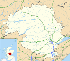
Dunkeld and Dowally — DUNKELD and DOWALLY, a parish, in the county of Perth, 15 miles (N. by W.) from Perth, and 55 (N. N. W.) from Edinburgh; comprising the ancient city of Dunkeld, partly within the parish of Caputh; for many years the seat of the primacy of the… … A Topographical dictionary of Scotland
Perthshire — Motto: Pro Lege et Libertate ( For Law and Liberty ) Perthshire within Scotland Geography … Wikipedia
Diocese of Dunkeld — Coordinates: 56°33′54″N 3°35′06″W / 56.565°N 3.585°W / 56.565; 3.585 This article is about historical … Wikipedia
Perthshire — Saltar a navegación, búsqueda Perthshire, Escocia Perthshire (Siorrachd Pheairt en gaélico), oficialmente el Condado de Perth, es un registro del condado en el centro de Escocia. Se extiende de Strathmore en el este, al paso de Drumochter en el… … Wikipedia Español
Perth, Scotland — Coordinates: 56°23′49″N 3°26′14″W / 56.396911°N 3.437262°W / 56.396911; 3.437262 … Wikipedia
Perth and Kinross — This article is about the Scottish local government area. For the former UK Parliamentary constituency abolished in 1997, see Perth and Kinross (UK Parliament constituency). Perth and Kinross Pairth an Kinross Peairt agus Ceann Rois Location … Wikipedia
Crieff — Coordinates: 56°22′32″N 3°50′33″W / 56.37568°N 3.84262°W / 56.37568; 3.84262 … Wikipedia
Dunning — For other uses, see Dunning (disambiguation). St Serf s Church. Dunning is a small village in Perth and Kinross in Scotland with a population of about 1,000. The village is built around the 12th 13th century former parish church of St. Serf,… … Wikipedia
Milnathort — is a small village in the Perth Kinross region of central Scotland. The smaller neighbour of nearby Kinross, Milnathort has a small population of roughly 1000 people. It is situated amidst picturesque countryside at the foot of the Ochil Hills,… … Wikipedia
 Dowally
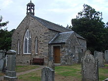 St Annes Church, Dowally

