- Dongargarh
-
Dongargarh — city — Coordinates Country India State Chhattisgarh District(s) Rajnandgaon Population 34,440 (2001[update]) Time zone IST (UTC+05:30) 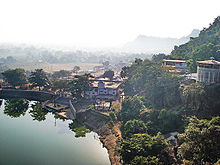

Dongargarh is a city and a municipality in Rajnandgaon district in the state of Chhattisgarh, India. Bamleshwari Temple on high hills is very picturesque . Dongargarh is one of the prominent pilgrim places in Rajnandgaon District of Chhattisgarh. It is about 35 km from Rajnandgaon and 67 km from Durg. Blessed with majestic mountains and ponds, Dongargarh has been derived from two words: 'Dongarh' meaning 'mountains' and 'garh' meaning 'fort'.
Popular of the landmarks is Maa Bamleshwari Devi Temple on a hilltop which is 1,600 ft high. It is of great spiritual importance and a legend is associated with this shrine. Another prominent shrine in the vicinity is Chhoti Bamleshwari Temple. The devotees flock these temples during Navratri. Shivji Temple and the temples dedicated to Lord Hanuman are also located here. The ropeway is an added attraction and is the only passenger ropeway in Chhattisgarh.
The nearest airport is at Raipur, 110 km away and the nearest railhead is Dongargarh Railway Station. Dongargarh has good road communication and buses and taxis are available from Rajnandgaon to reach here.
Demographics
As of 2001[update] India census,[1] Dongargarh had a population of 34,440. Males constitute 51% of the population and females 49%. Dongragarh has an average literacy rate of 73%, higher than the national average of 59.5%: male literacy is 81% and, female literacy is 66%. In Dongragarh, 12% of the population is under 6 years of age.Dongargarh has sizable and dominant sikh and buddhist population.marwaris,jains,sikhs own most of the business setups.
Education
In the field of Education, Dongargarh is a very well known city in the state of Chhattisgarh, India. It has two very high quality schools. First, Jawahar Navodaya Vidyalaya (Only Navodaya school in Rajnandgaon District) & second Kendriya Vidyalaya (Central School).
References
- ^ "Census of India 2001: Data from the 2001 Census, including cities, villages and towns (Provisional)". Census Commission of India. Archived from the original on 2004-06-16. http://web.archive.org/web/20040616075334/http://www.censusindia.net/results/town.php?stad=A&state5=999. Retrieved 2008-11-01.
Coordinates: 21°11′18″N 80°45′32″E / 21.18842°N 80.75875°E
Cities and towns in Rajnandgaon district Rajnandgaon Ambagarh Chowki · Chhuikhadan · Dongargaon · Dongragarh · Gandai · Khairagarh · Rajnandgaon
Cities and towns
in other districtsCategories:- Cities and towns in Rajnandgaon district
- Railway stations in Chhattisgarh
- Chhattisgarh geography stubs

Wikimedia Foundation. 2010.