- Algoma District
-
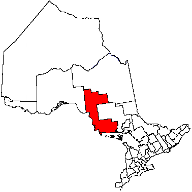
Algoma District — District — Agawa Canyon Location of Algoma District in Ontario
Coordinates: 48°00′N 84°30′W / 48°N 84.5°WCoordinates: 48°00′N 84°30′W / 48°N 84.5°W Country  Canada
Province  Ontario
Region Northeastern Ontario Created 1858 Area – Total 48,734.66 km2 (18,816.6 sq mi) Population (2006)[1] – Total 117,461 – Density 2.4/km2 (6.2/sq mi) Canada 2006 Census Time zone EST (UTC-5) – Summer (DST) EDT (UTC-4) Postal code span Area code(s) 705 Seat Sault Ste. Marie Website Algoma District Services Administration Board Algoma District is a district and census division in Northeastern Ontario in the Canadian province of Ontario. It was created in 1858 comprising territory as far west as Minnesota. Since then, it has shrunk, as other districts were created by the provincial government:
- Thunder Bay District in 1871
- Manitoulin District in 1888
- Sudbury District in 1894
- Timiskaming District in 1912
The district seat is Sault Ste. Marie.
The rugged scenery of this region has inspired works by Canadian artists, particularly the Group of Seven, who rented a boxcar from the Algoma Central Railway during excursions through this region.
Contents
Subdivisions
Communities within these subdivisions are added in parentheses.
Cities
Towns
Townships
- Dubreuilville
- Hilton
- Hornepayne
- Huron Shores (Iron Bridge, Sowerby, Little Rapids)
- Jocelyn (Kentvale)
- Johnson (Desbarats)
- Laird
- Macdonald, Meredith and Aberdeen Additional (Echo Bay, Bar River, Sylvan Valley)
- North Shore (Spragge, Serpent River, Algoma Mills)
- Plummer Additional
- Prince
- St. Joseph (Richard's Landing)
- Tarbutt and Tarbutt Additional
- Wawa (Michipicoten, Michipicoten River)
- White River
Villages
Reserves
- Garden River
- Goulais Bay
- Gros Cap
- Missanabie
- Mississagi River
- Rankin Location
- Sagamok
- Serpent River
- Thessalon
Unorganized areas
- North (incl. local services boards of Aweres, Batchawana Bay, Goulais and District, Hawk Junction, Missanabie, Peace Tree, Searchmont and Wharncliffe and Kynoch)
- South East
Highways
King's Highways
Secondary highways
- #556
- #557
- #563
- #565
- #631
- #638
- #639
- #651
- #670
Tertiary highways
- #810
Protected areas
- Algoma Headwaters Provincial Park
- Aubinadong River Provincial Park
- Aubrey Falls Provincial Park
- Batchawana Bay Provincial Park
- Batchawana River Provincial Park
- Chapleau Crown Game Preserve
- Chapleau-Nemegosenda River Provincial Park
- Delta Provincial Nature Reserve
- Fort Creek Conservation Area
- Goulais River Provincial Park
- Hiawatha Highlands Conservation Area
- La Cloche Provincial Park
- Lake Superior Provincial Park
- Little White River Provincial Park
- Marks Bay Conservation Area
- Matintenda Provincial Park
- Michipicoten Post Provincial Park]
- Missinaibi Provincial Park
- Mississagi Provincial Park
- Mississagi River Provincial Park
- Montreal River Provincial Park
- Nagagami Lake Provincial Park
- Nagagamisis Provincial Park
- Nemegosenda River Wetlands Provincial Park
- North Channel Silands-La Cloche Provincial Park
- North Shore Waterwat Provincial Park
- Obatanga Provincial Park
- Pancake Bay Provincial Park
- Pichogen River Provincial Nature Reserve
- Pokei Lake-White River Wetlands Provivncial Nature Reserve
- Potholes Provincial Nature Reserve
- Pukaskwa River National Park
- River aux Sables Provincial Park
- Sandy Islands Provincial Nature Reserve
- Sayme-Aubinadong-Gong Provincial Park
- St. Joseph's Island National Marine Bird Sanctuary
- Wenebegon River Provincial Park
Attractions
- Algoma Central Railway - Agawa Canyon (Algoma, Unorganized, North Part)
- Algoma University (Sault Ste. Marie)
- Fire Tower Lookout (Elliot Lake)
- Fort St. Joseph National Historic Site (St. Joseph)
- High Falls of the Michipicoten River (Wawa)
- Mount Dufour Ski Resort (Elliot Lake)
- Sault Ste. Marie Airport (Sault Ste. Marie)
- Sault Ste. Marie Canal (Sault Ste. Marie)
- Sault College (Sault Ste. Marie)
- Searchmont Ski Area
- Stone Ridge Golf Resort (Elliot Lake)
Demographics
(Statistics Canada, 2006)
- Population: 117,461
- Population change (2001–2006): -0.9
- Dwellings: 58,472
- Area (km²): 48,734.66
- Density (per km².): 2.4
- National rank in terms of population: 50
- Provincial rank in terms of population: 21
References
External links

Cochrane District Thunder Bay District
Lake Superior
Sudbury District  Algoma District

Chippewa County, Michigan (U.S.A.), Manitoulin District Algoma District, Ontario Cities 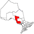
Towns Townships Dubreuilville • Hilton • Hornepayne • Huron Shores • Jocelyn • Johnson • Laird • Macdonald, Meredith and Aberdeen Additional • North Shore • Plummer Additional • Prince • St. Joseph • Tarbutt and Tarbutt Additional • Wawa • White RiverVillages Hilton BeachFirst Nations Batchewana • Garden River • Hornepayne • Michipicoten • Missanabie • Mississauga • Sagamok • Serpent River • ThessalonIndian reserves Chapleau 61 • Garden River • Goulais Bay • Gros Cap • Gros Cap Village • Missanabie • Mississagi River • Obadjiwan • Rankin Location • Sagamok • Serpent River • Thessalon • Whitefish IslandLocal services boards Aweres • Batchawana Bay • Goulais and District • Hawk Junction • Missanabie • Peace Tree • Searchmont • Wharncliffe and KynochUnorganized areas North • South EastSee also: Communities in Algoma District • Census divisions of OntarioCategories:


Wikimedia Foundation. 2010.