- Dirkou
-
Dirkou
Dirki— Commune —  Location in Niger
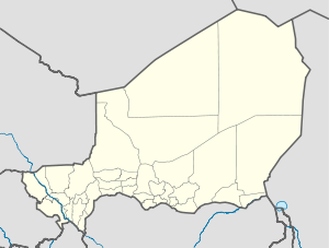
 Dirkou
Coordinates: 19°2′N 12°54′E / 19.033°N 12.9°ECoordinates: 19°2′N 12°54′E / 19.033°N 12.9°E Country Niger Region Agadez Region Department Bilma Department Commune Dirkou Elevation 1,601 ft (487 m) Time zone WAT (UTC+1) [1]
Dirkou is a town in the Bilma Department, Agadez Region of north-eastern Niger. It lies in the northern Kaouar escarpment, a north-south line of cliffs which form an isolated oasis in the Sahara desert.The town is just south of Séguédine, and around 90 km north of Departmental capital Bilma. While isolated in modern Niger, it once lay on the important central soudan route of the Trans-Saharan trade which linked coastal Libya and the Fezzan to the Kanem-Bornu Empire near Lake Chad. Its population is made up primarily of traditionally sedentary Kanuri people, as well as semi-nomadic Tuareg and Tubu people.[2][3]
Transport
The town is served by Dirkou Airport.
References
- ^ Dirkou, Niger Page. Falling Rain Genomics, Inc. 1996-2004
- ^ Decalo, Samuel (1997). Historical Dictionary of the Niger (3rd ed.). Boston & Folkestone: Scarecrow Press. ISBN 0810831368.
- ^ Geels, Jolijn (2006). Niger. Chalfont St Peter, Bucks / Guilford, CT: Bradt UK / Globe Pequot Press. ISBN 9781841621524.
 Communes of Niger
Capital: Niamey Urban communes Abalak · Agadez · Aguie · Arlit · Bilma · Birni N'Gaoure · Birni N'Konni · Bouza · Dakoro · Diffa · Dogondoutchi · Dosso · Filingue · Gaya · Guidanroumdji · Goure · Illela · Keita · Kollo · Loga · Madaoua · Madarounfa · Magaria · Maine Soroa · Maradi I · Maradi II · Maradi III · Matamey · Mayahi · Mirriah · N'Guigmi · Commune I (Niamey) · Commune II (Niamey) · Commune III (Niamey) · Commune IV (Niamey) · Commune V (Niamey) · Ouallam · Say · Tahoua I · Tahoua II · Tanout · Tchintabaraden · Tchirozerine · Tessaoua · Téra · Tibiri · Tillaberi · Zinder I · Zinder II · Zinder III · Zinder IV · Zinder VRural communes Abala · Aderbissinat · Adjekoria · Affala · Akoubounou · Albarkaram · Alakoss · Allakaye · Allela · Anzourou · Attantane · Ayerou · Azagor · Azarori · Azeye · Babankatami · Badaguichiri · Bader Goula · Bagaroua · Bambeye · Bana · Bande · Bangui · Banibangou · Bankilare · Baoudetta · Barmou · Bazaga · Bengou · Bermo · Bibiyergou · Birni Lalle · Bitinkodji · Bosso · Boune · Chadakori · Chetimari · Dabaga · Dakoussa · Damagaram Takaya · Dan-Barto · Dan-Goulbi · Dan-Issa · Dan-Kassari · Dannet · Dantchiao · Daouche · Dargol · Deoule · Dessa · Diagourou · Diantchandou · Dingazi · Dirkou · Dioundiou · Djado · Djiratawa · Dogo · Dogo-Dogo · Dogonkiria · Doguerawa · Doumega · Doungou · Droum · Dungass · El Allassane Maireyrey · Fabidji · Fachi · Fakara · Falenko · Falmey · Falwel · Farey · Foulatari · Gabi · Gababedji · Gaffati · Galma Koudawatche · Gamou · Gangara · Gangara · Garagoumsa · Garhanga · Garankedey · Gazaoua · Golle · Goroubankassam · Gorouol · Gothèye · Gouchi · Goudoumaria · Gougaram · Gouna · Guecheme · Gueskerou · Guidan Amoumoune · Guidan Sori · Guidiguir · Guidimouni · Guilladje · Hamdallaye · Hamdara · Harikanassou · Hawandawaki · Ibrohamane · Ichirnawa · Ifernouane · Imanan · Inates · Ingall · Issawane · Kablewa · Kao · Kalfou · Kanan-Bakache · Kankandi · Kantche · Karakara · Kargiubangou · Karma · Karofane · Kelle · Kieche · Kiota · Kirtachi · Kokorou · Kolleram · Koona · Korahane · Kore Mairoua · Korgom · Kornaka · Kouré · Kourfeye · Kourni · Kourteye · Koygolo · Kwaya · Libore · Maijirgiu · Maiyara · Malawa · Malbaza · Matankari · Mehana · Moa · Mokko · N'Dounga · N'Gonga · N'Gourti · N'Guelbely · Namaro · Ollelewa · Ourafane · Ouro Gueladjo · Ourno · Roumboui · Sabon-Guida · Sabon-Machi · Sae Saboua · Safo · Sakoira · Sambera · Sanam · Sarkin Haoussa · Sarkin Yamma · Sassoumbroum · Simiri · Sinder · Sokorbe · Soucoucoutane · Tabalak · Tabelot · Tabotaki · Tagazar · Tagriss · Tajae · Takanamat · Tama · Tamaske · Tamaya · Tamou · Tanda · Tarka · Tassara · Tchadoua · Tchake · Tebaram · Tenhya · Tesker · Tessa · Tibiri (Doutchi) · Timia · Tillia · Tirmini · Tombokoirey I · Tombokoirey II · Tondikandia · Tondikiwindi · Torodi · Toumour · Tounounga · Tsaouni · Tsernaoua · Wacha · Wame · Yaouri · Yekoua · Yelou · YouriCategories:- Niger geography stubs
- Communes of Niger
- Populated places in Niger


Wikimedia Foundation. 2010.