- Dinmael
-
Dinmael was a medieval lordship and cwmwd in north Wales which usually formed a part of the patrimony of the kingdom of Powys. The name, of Old Welsh origin, means "the King's Fort" (Din "fort" + Mael "king") and probably refers to a now forgotten early Welsh fortress.
The name survives in the name of a rural community in the modern county of Conwy; however the modern community is much smaller than the medieval lordship.
Notes
References
Conwy County Borough Principal settlements Abergele • Colwyn Bay • Conwy • Llandudno • Llandudno Junction • Llanfairfechan • Llanrwst • Old Colwyn • Penmaenmawr • Penrhyn Bay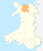
Towns and villages Bettws-y-Coed • Caerhun • Capel Curig • Capel Garmon • Cerrig-y-drudion • Deganwy • Dinmael • Dolgarrog • Dolwyddelan • Eglwysbach • Glan Conwy • Henryd • Kinmel Bay • Llanbedr-y-Cennin • Llanddoged • Llanddulas • Llanfair Talhaiarn • Llangernyw • Llanrhychwyn • Llysfaen • Maenan • Mochdre • Pandy Tudur • Penmachno • Rhos-on-Sea • Rowen • Tal-y-bont • Tal-y-Cafn • Trefriw • Towyn • Ysbyty IfanRivers Castles and forts Canovium • Conwy Castle • Deganwy Castle • Dolwyddelan Castle • Gwrych Castle • Gwydir Castle • Pen y GaerCategories:- Cantrefs
- Conwy County Borough

Wikimedia Foundation. 2010.