- Deoria, Uttar Pradesh
-
This article is about the municipality in Uttar Pradesh, India. For its namesake district, see Deoria district. For Deoria district, see Lok Sabha constituency. For Deoria (Lok Sabha constituency), see Deoria, Uttar Pradesh (disambiguation).
Deoria — city — Coordinates 26°30′N 83°47′E / 26.5°N 83.79°ECoordinates: 26°30′N 83°47′E / 26.5°N 83.79°E Country India State Uttar Pradesh District(s) Deoria Population 3,098,637 (2011[update]) Time zone IST (UTC+05:30) Area
• 68 metres (223 ft)
Website http://deoria.nic.in/ Deoria (Hindi: देवरिया Urdu: دیوریا) is a town in the state of Uttar Pradesh, India. It is one of 5 tehsils of Deoria district. The name of the Railway Station is Deoria Sadar(Hindi: देवरिया सदर).
Contents
Geography
Deoria is located 50 km to south-east of Gorakhpur.
Demography
According to 2001 census Deoria had 104222 inhabitants (54.737 men, 49.485 women).[1]
History
Ancient
The area now known as the Deoria District was once a part of the Kosala Kingdom - a prime centre of ancient Aryan culture surrounded by the Himalayas in the north, the Shyandika river in the south, the Panchala Kingdom in the west and the Magadh Kingdom in Bihar to the east. Apart from the many legends told about this area, archaeological remains, such as statues, coins, bricks, temples, and Budh Maths, have been discovered at many locations in this district, showing that there was a developed and organised society long ago.
Ancient history of the district is related with the Ramayana times when the Lord of Kosala, Ram, appointed his elder son Kusa the king of Kushwati, which is present-day Kushinagar. Before the Mahābhārat era, this area had been related with Chakravorty Samrat Mahasudtsan Mall and his kingdom. Kushinagar was well developed and prosperous. Close to the border of his kingdom was the thick forested area called the Mahavan. This area was under the control of the Maurya rulers, the Gupta rulers, the Bihar rulers, and then the Garhwal ruler Govinda Chandra from 1114 AD until 1154 AD.
Modern
The Deoria District came into existence on March 16, 1946, being separated from the Gorakhpur District. It is believed that the name Deoria is derived from Devaranya or possibly Devpuria. According to official gazetteers, the district was named "Deoria" after its headquarters in Deoria, and the term Deoria generally means a place where there are temples. The name Deoria probably developed because of the existence of important temples to Shiva, called Somnath Temple, and the goddess Durga, called Deorahi Temple on the northern bank of the Kurna river.
The Kushinagar (Padrauna) district was formed in May 1994 by separating the north-east portion of the Deoria District.
Educational facilities
Degree colleges
- Baba Raaghav Das PG College (Purwan, Deoria-Gorakhpur road)
- Sant Vinova Degree College (New Colony)
- Mahila Post Graduate College (Uma Nagar, Hanuman Mandir Road)
Technical institutes
- ITI Deoria (Salempur Road)
- Government polytechnic college Deoria (Gorakhpur road)
Schools
- B.N.PUBLIC SCHOOL,Near Brahma Sthan,Banzaria Bazar,Deoria
- Maharaja Agrasen Intermediate College (Jalkal Road)
- Deoria Senior Secondary School (Gorakhpur Road)
- D.L.S. High School (parasiya mall, deoria)
- Government Intermediate College (Kotwali Road)
- Kasturba Girls Intermediate College (Near Head Post Office)
- Baba Raaghav Das Intermediate College (New Colony)
- SSBL Intermediate College (Near Over bridge)
- Maharaja Agrasen Girls Intermediate College (Near Vijay Cinema)
- Saraswati Vidya Mandir (Deoria Khas)
- Central Academy (Jail Road)
- Navjeean Mission School (Jail Road)
- Jeevan Marg Sophia Secondary (Raghav Nagar)
- Prestige Tutorial Intermediate College (Near Over Bridge)
- Kendriya Vidyalay I T I Campus Barhaj Road
- Heritage public school & classes (Bhujouli colony, deoria, U.P.)
- Sant Pushpa High School, Shanti Nagar, Deoria(U.P)
- Central Academy, Salempur road
- Pt. deen dayal intermediate college , deoria
- S.M.S. Rashtriya intermediate Samipatti, Deoria
- H.B.M.U.M.V.Deoriameer, Deoria
- R.D.Convent School (Deoria Khas)
- life line public school pakari bazar,deoria
List of colonies/mohalla
- Kailashpuri
- Bhatwaliya
- NathNagar
- RamNath Deoria
- Rahghav Nagar
- Saket Nagar
- New Colony
- Sabzi Mandi
- Ram Gulam Tola
- Shastri Nagar
- Nehru Nagar
- Acharya Ram Chandra Shukla Nagar
- Ambedkar Nagar
- Aboobkar Nagar
- Deoria Khas
- Uma Nagar
- Sindhi Mill
- tubel colony
- gayatri puram , mall colony
- pandit durga prasad mishr main road to haluman mandir
Libraries
- Town Hall Library(Near Union Bank, Malviya Road)
- Naagiri Pracharini(In front of GIC Gate,Kotwali Road)
- GIC Library(Jalkal Road)
- District Library, New colony
- GauriBazar,Gkp-Deoria Road
Temples
-

Amethi Mandir
-

Gaytri Mandir
-

Balaji Mandir
-

Somnath Mandir
-
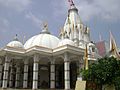
Shyam Mandir
References
External links
Divisions and Districts of Uttar Pradesh, India Agra division Aligarh division Aligarh · Etah · Mahamaya Nagar · Kanshi Ram Nagar
Allahabad division Azamgarh division Bareilly division Badaun · Bareilly · Pilibhit · Shahjahanpur
Basti division Chitrakoot division Banda · Chitrakoot · Hamirpur · Mahoba
Devipatan division Faizabad division Gorakhpur division Deoria · Gorakhpur · Kushinagar · Maharajganj
Jhansi division Kanpur division Auraiya · Etawah · Farrukhabad · Kannauj · Kanpur Nagar · Ramabai Nagar
Lucknow division Meerut division Bagpat · Bulandshahr · Gautam Buddha Nagar · Ghaziabad · Meerut · Panchsheel Nagar
Mirzapur division Moradabad division Bhimnagar · Bijnor · Jyotiba Phule Nagar · Moradabad · Rampur
Saharanpur division Prabuddhanagar · Muzaffarnagar · Saharanpur
Varanasi division Gorakhpur division topics General Mythology, history Districts Rivers, dams, lakes Ghaghara • West RaptiLanguages, people Transport Lok Sabha constituencies See also Cities and towns in Deoria district • Cities and towns in Gorakhpur district • Cities and towns in Kushinagar district • Cities and towns in Maharajganj district • Villages in Deoria district • Villages in Gorakhpur district • Villages in Maharajganj district • People from Deoria • People from Gorakhpur • People from Kushinagar • People from MaharajganjOther Divisions Agra • Aligarh • Allahabad • Azamgarh • Bareilly • Basti • Chitrakoot • Devipatan • Faizabad • Jhansi • Kanpur • Lucknow • Meerut • Mirzapur • Moradabad • Saharanpur • VaranasiCategories:- Religious Places
- Deoria


Wikimedia Foundation. 2010.