- Denstone railway station
-
Denstone 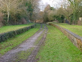
Location Place Denstone Area Staffordshire Moorlands, Staffordshire Coordinates 52°57′51″N 1°51′03″W / 52.96411°N 1.85078°WCoordinates: 52°57′51″N 1°51′03″W / 52.96411°N 1.85078°W Operations Original company North Staffordshire Railway Pre-grouping North Staffordshire Railway Post-grouping LMS
London Midland RegionPlatforms 2 History 13 July 1849 Station opened 4 January 1965 Station closed (passenger) Disused railway stations in the United Kingdom Closed railway stations in Britain
A B C D–F G H–J K–L M–O P–R S T–V W–ZDenstone railway station is a closed station on the Churnet Valley railway, which served the village of Denstone in Staffordshire.
History
The Churnet Valley railway was authorised on 26 June 1846 and opened on 13 July 1849. It generally followed the course of the former Uttoxeter Canal, as it was built to transport goods previously transported along the canal. It closed to passengers on 4 January 1965.[1]
References
- ^ Scott, Peter (1998). A history of the Alton Towers railway: including other railways & transport systems at Alton Towers, together with the railways at Lilleshall Hall & Trentham Gardens. Peter Scott. p. 65. ISBN 1902368061. http://books.google.co.uk/books?id=xsVyeQh3_GUC&source=gbs_navlinks_s. Retrieved 19 October 2009.
Route
Preceding station Disused railways Following station Alton North Staffordshire Railway
Churnet Valley RailwayRocester Categories:- Disused railway stations in Staffordshire
- East Staffordshire
- Former North Staffordshire Railway stations
- Beeching closures in England
- Staffordshire building and structure stubs
- West Midlands (region) railway station stubs

Wikimedia Foundation. 2010.