- Letete to Deer Island Ferry
-
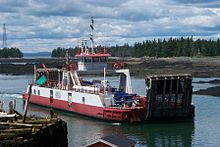 One of two ferries operated on the Letete to Deer Island Ferry.
The Letete to Deer Island Ferry is a ferry in the Canadian province of New Brunswick. The ferry crosses Passamaquoddy Bay, linking Letete on the east side of the bay to Deer Island towards the west side of the bay. It is currently served by the ferries Deer Island Princess II and John E. Rigby. [1]
The crossing is 5 kilometres (3.1 mi) in length, takes 20 minutes, and is free of tolls. The two ferries provide service on the route, carrying up to 24 cars at a time. Service is provided year round, with ferries operating at least hourly between 0600 and 2200, and half-hourly for most of the day. The service is operated by the New Brunswick Department of Transportation, and during the winter months provides the only road access to Deer Island.[1]
The two ferries are both a propeller driven. The Deer Island Princess II has a car capacity of 24, a passenger capacity of 99, a gross tonnage of 335 and a net tonnage of 95. First registered in 2001, she is 39.90 metres (130.9 ft) in length, 12.50 metres (41.0 ft) in breadth and 2.40 metres (7 ft 10 in) in depth. The John E. Rigby has a car capacity of 17, a passenger capacity of 30, a gross tonnage of 231 and a net tonnage of 227. First registered in 1976, she is 30.97 metres (101.6 ft) in length, 11.91 metres (39.1 ft) in breadth and 2.16 metres (7 ft 1 in) in depth.[1][2][3]
During the summer, privately operated ferries provide alternative access to Deer Island, linking it to the New Brunswick island of Campobello, and to the city of Eastport in the US state of Maine.
References
- ^ a b c "Ferries". New Brunswick Department of Transportation. http://www.gnb.ca/0113/ferries/ferries-e.asp. Retrieved 2008-11-17.
- ^ "Deer Island Princess II". Canadian Transportation Agency. http://forms.cta-otc.gc.ca/CVIS/Ship_e.cfm?ShipID=823396. Retrieved 2008-11-24.
- ^ "John E. Rigby". Canadian Transportation Agency. http://forms.cta-otc.gc.ca/CVIS/Ship_e.cfm?ShipID=345441. Retrieved 2008-11-24.
External links
Coordinates: 45°02′16″N 66°54′53″W / 45.037869°N 66.914635°W
Categories:- Ferries of New Brunswick

Wikimedia Foundation. 2010.