- Cwmystwyth Mines
-
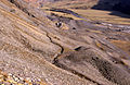
 Cwm Ystwyth mine scape, present day
Cwmystwyth mines are located in Cwmystwyth, Ceredigion, Wales.
Contents
Mining heritage
Cwm Ystwyth is considered the most important non-ferrous metal mining site in Wales providing a premier example of mining heritage in Ceredigion. Within the site there is evidence for all phases of mining activity; from the Bronze Age, through the medieval period, to its revival in the 18th century and the peak of activity with a subsequent decline in the late 19th and the early 20th century. It has been designated as a Scheduled Ancient Monument.[1] The site also features prominently in the Upland Ceredigion Landscape of Historic Interest.
History
Silver, lead and zinc have been mined in the valley of the River Ystwyth since Roman times, an activity that reached its peak in the 18th century. The largest of the very many mines was Cwmystwyth Mine. It is reputed that the average age at death of the miners in Cwmystwyth was 32, largely because of acute lead poisoning. There is no longer any active metal mining in the Ystwyth valley.
Water use
Water was extensively used during the silver and lead mining process to extract the ore. In the case of Cwm Ystwyth mine, much of the water was brought in by contour hugging leats from several miles upstream. The channel of the leat can still be followed on the hillside and is clearly visible from the road on the opposite side of the valley. Much of the water was used for hushing, prospecting and working the ore in the open.
Banc Ty'nddôl sun-disc
In October 2002 the Banc Ty'nddôl sun-disc was discovered on the mining site. The disc is over 4,000 years old, which makes it the earliest gold artifact discovered in Wales.
Gallery
-

Main building of Cwmystwyth lead mine
-

Graig y Ddalfa at Cwmystwyth lead mines
-

Old mine workings below Craig-y-Ddolfa, east of Cwmystwyth
-

Abandoned building, old lead mine, Cwmystwyth.
-
View of the mine workings with one of the many leats in the foreground
-

|Cwmystwyth Mine from the hill-side immediately above the mine. Winter in 1985 when many buildings were still standing
Footnotes
References
- Register of Landscapes of Outstanding Historic Interest in Wales, Cadw (Cardiff, 1998), pp. 12-16.
- For a comprehensive account of the mine during the historic period, see Hughes, Simon J., The Cwmystwyth Mines, (2nd edn., Talybont, 1993);
- Prehistoric period, see Timberlake, S. and Mighall, T., 'Historic and Prehistoric Mining on Copa Hill', Archaeology in Wales, 32 (1992), pp. 38-44.
- Cambrian Mountains: Metal Mines Project, by Brian Clouston and Partners, and Parkman Consulting Engineers, (unpublished report to Dyfed County Council, December 1988)
- Simon Timberlake. "The Banc Ty'nddôl sun-disc - one of Wales's earliest gold objects". Celtic Design Studio. http://www.celticdesignstudio.co.uk/the-banc-tynddol-sun-disc.html. Retrieved 2008-11-07.[dead link]
- Morgan, Gerald (2005). Ceredigion, A Wealth of History. Ceredigion, Wales: Gomer. ISBN 1843233487.
- Timberlake, S. 2002 a Medieval lead smelting boles near Penguelan, Cwmystwyth, Archaeology in Wales 42: 45-59
- — 2002 b Cwmystwyth, Banc Ty'nddôl: gold disc, AW 42, 97-98 Timberlake, S. 2003 Excavations on Copa Hill, Cwmystwyth (1986–1999); An Early Bronze Age copper mine within the uplands of Central Wales. BAR British Series 348 Oxford: Archaeopress.
- Timberlake, S., A. Gwilt & M. Davis. In prep. The Banc Ty'nddôl Gold Disc. The Proceedings of the Prehistoric Society.
- "A Copper Age/ Early Bronze Age gold disc from Banc Ty'nddôl (Penguelan, Cwmystwyth Mines, Ceredigion)". Antiquity Vol 78 No 302 December 2004. http://www.antiquity.cc/ProjGall/timberlake/index.html. Retrieved 2008-11-07.
External links
 Media related to Cwmystwyth mines at Wikimedia Commons
Coordinates: 52°21′19″N 3°46′09″W / 52.355299°N 3.769283°W
Categories:- History of Ceredigion
- Mines in Wales
- Scheduled Ancient Monuments in Wales
- Archaeological sites in Ceredigion
- Elenydd
-


Wikimedia Foundation. 2010.