- Cwm Gwaun
-
Coordinates: 51°58′08″N 4°52′00″W / 51.968814°N 4.866606°W
Cwm Gwaun 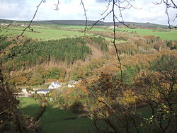
 Cwm Gwaun
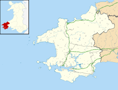
Cwm Gwaun shown within PembrokeshirePrincipal area Pembrokeshire Ceremonial county Dyfed Country Wales Sovereign state United Kingdom EU Parliament Wales List of places: UK • Wales • Pembrokeshire Cwm Gwaun is a village and community in northern Pembrokeshire. Located just to the west of Pontfaen (which is part of the community), it lies 4.3 miles east of Fishguard.
Geography
In 2008 the community was reported to have an area of 3870 hectares and have a population of 266 inhabitants.[1] The Companion Guide to Wales describes Cwm Gwaun as "one of the most important meltwater channels from the last ice age to be found in the British Isles." [2] The Gwaun River rises in the Preseli hills near the village and its tributaries have carved heavily-wooded steep, narrow side-valleys. To the northwest are hills such as Mynydd Dinas and Mynydd Melyn and the valley forms a notable wetland.[3] Trees found in the valley include sessile oak, beech, alder, rowan, ash and willow.[2] The highest point of the Preseli hills is Foel Cwmcerwyn at 535 metres.[4] The area is a notable 5.2 mile (8.32km) nature walk area of the Pembrokeshire Coast National Park.[5] The Rough Guide to Wales says of the community, "Cwm Gwaun and the inland hills Cwm Gwaun, the valley of the burbling River Gwaun is one of the great surprises of Pembrokeshire – a bucolic vale of impossibly narrow lanes, surrounded by the bleak shoulders of bare mountains."[6]
Notable landmarks
 The Dyffryn Arms, Pontfaen, a.k.a. Bessie's
The community (Pontfaen) contains a primary school and a pub of considerable local renown named the Dyffryn Arms, known locally as Bessie's and run by Bessie Davies's family since 1840.[7] The locals continue to follow the tradition of the pre-1752 calendar and celebrate New Year on the 13th of January.[2][6] The Gwaun Valley also contains a brewery at the Kilkiffeth Farm.[8]
 Local primary school
References
- ^ Davies, John; Jenkins, Nigel; Baines, Menna (2008). The Welsh Academy encyclopaedia of Wales. University of Wales Press. ISBN 978-0-7083-1953-6. http://books.google.com/books?id=-ZEUAQAAIAAJ. Retrieved 20 September 2011.
- ^ a b c Barnes, David (2005). The companion guide to Wales. Companion Guides. p. 240. ISBN 978-1-900639-43-9. http://books.google.com/books?id=Np_H_j3hXUEC&pg=PA240. Retrieved 20 September 2011.
- ^ British wildlife. British Wildlife Publishing. 2006. pp. 35–36. http://books.google.com/books?id=j_pJAAAAYAAJ. Retrieved 20 September 2011.
- ^ Else, David (2007). Great Britain. Lonely Planet. p. 688. ISBN 978-1-74104-565-9. http://books.google.com/books?id=963H_WwdUVUC&pg=PA688. Retrieved 20 September 2011.
- ^ "Cwm Gwaun". BBC. http://www.bbc.co.uk/wales/southwest/nature/thingstodo/walks/allwalks/cwm_gwaun.shtml. Retrieved 20 September 2011.
- ^ a b Nevez, Catherine Le; Parker, Mike; Whitfield, Paul (28 April 2009). The Rough Guide to Wales. Rough Guides. p. 211. ISBN 978-1-84836-050-1. http://books.google.com/books?id=I6z234p43ggC&pg=PA211. Retrieved 20 September 2011.
- ^ Rough Guides Ltd. (COR) (2 May 2011). Rough Guides Make the Most of Your Time in Britain: 500 Great British Experiences. Rough Guides. p. 78. ISBN 978-1-84836-685-5. http://books.google.com/books?id=i56eoVOcm8AC&pg=PA78. Retrieved 20 September 2011.
- ^ "Microbrewery in Pembrokeshire, Wales". Gwaun Valley Brewery. http://www.gwaunvalleybrewery.co.uk/. Retrieved 20 September 2011.
Categories:- Villages in Pembrokeshire
- Communities in Pembrokeshire


Wikimedia Foundation. 2010.