- Cross Seamount
-
Cross Seamount 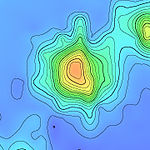
Cross Seamount bathymetric.Summit depth 595 m (1,952 ft)[1] Height 4,300 m (14,108 ft)[1] Summit area volume: 1796km3[1] Location Location Southwest of the Hawaii archipelogo Group small A1 Seamount[1] Coordinates 18°42′16″N 158°15′58″W / 18.70444°N 158.26611°WCoordinates: 18°42′16″N 158°15′58″W / 18.70444°N 158.26611°W[1] Country Hawaii Geology Type Underwater volcano (Seamount) Volcanic arc/chain Hawaiian-Emperor seamount chain Age of rock 102.8 - 103.3 Million years[1] Last eruption Pre-ancient times Cross Seamount is a seamount far southwest of the Hawaii archipelago, about equidistant from the cities of Honolulu and Kona. It is one of the numerous seamounts surrounding Hawaii, although unrelated to the Hawaiian hotspot.[2] It is notable for being one of the best studied of the numerous seamounts surrounding Hawaii, as it has been included in numerous biological surveys, most recently in 2007. It is also a site of offshore fishing, for its abundant tuna. The fishery management problems at Cross Seamount are typical of management problems in many fisheries, and its small size makes it a scientifically useful model for the analysis of fishery management.[3]
Contents
Geology
Cross Seamount, a landform arising from the ocean floor, is one of the more distant lesser seamounts surrounding the island of Hawaii.[2] The NOAA has taken advantage of Cross Seamount’s position, and planted several weather buoys on the seamount.[4] Very little is known about Cross Seamount's geology, as all of its studies as of March 2009 were of its ecology; however, it was mapped in 1996 by a four year effort to map all of Hawaii's seafloor in detail.[2]
Biology
History of fishing
Cross Seamount is well known in fishery and scientific communities for its small but abundant biologic community. Longline fishing ships occasionally fished at Cross Seamount for many years prior to the development of handline fishing, in 1976. The level of fishing remained fairly constant up until the mid 1980. In the late 1980s, the amount of fishing activity at Cross Seamount more than quadrupled; however, it is hard to tell because of limited data.[3]
 Bigeye tuna, one of Cross's two common fish species.
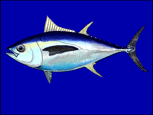
 Yellowfin tuna, the other of Cross's common fish species.
Local tuna populations belong to the same general stocks of tuna that are widely distributed throughout the Pacific.[3] There are no accurate size data collected on the catches from fishing, aside from limited port sampling by the National Marine Fisheries Service. However, it is known that the largest percent of the catches are juvenile tuna between 10 and 35 pounds.[3] These fish are probably somewhere between one and two years of age, well below sexual maturity. Fishermen report that the offshore fishing grounds are productive year-round. However, during summer months, large Yellowfin tuna tuna are more abundant. The weight of the catches are estimated to be about 75% Thunnus obesus (Bigeye tuna), and 25% T. albacares (Yellowfin tuna).[3] According to estimates, about 1 million pounds of Bigeye tuna and 400,000 pounds of Yellowfin were fished from offshore operations from the region in 1995.[3] The amount of tuna is thought to depend on conditions on the seamount, and on the current process range range of the tuna schools.[5]
Concerns and studies
Reviews of the local catches have seemed to show no impact of the fishing operation on nearby tuna fishing. However, this is not very surprising, as fishery operations exist nearby with as much as 1000 times the activity. Nevertheless, as tuna spawn locally, there are concerns that the fishing eats away at the juvenile tuna population, which has the potential to seriously hurt fish numbers.[3]
1995 tagging project
In 1995, a project to tag the local fish, to analyze the population, was implemented by the NOAA, based on a plan proposed by fishermen in 1992.[3] The first fish were tagged and released in August 1995. [3] The objectives of the project was to investigate the retention rates of tuna on the Cross Seamount, movement patterns of tuna in relation to the fishery patterns, and the interaction between surface and longline fishing.[4]
Capture Rates[4] Recovery Rates[4] Bigeye
Yellowfin
OTC Non-OTC OTC Non-OTC Location
Cross Seamount 567 1360 1 867 Buoy 2 474 316 2 321 Buoy 3 0 428 0 85 Buoy 4 0 199 0 98 Other Buoy 0 55 0 86 Total 1041 2358 3 1457 SPP Total 3399 1460 Grand Total 4859 Bigeye
Yellowfin
OTC Non-OTC OTC Non-OTC Location
Cross Seamount 44 33 0 86 Buoy 2 69 5 0 12 Buoy 4 1 2 0 5 Other Buoy 0 6 0 4 Other 2 4 1 8 Unknown 2 8 0 2 Total 118 58 1 117 SPP Total 176 118 Grand Total 294 The recovery rate was found to be 5.2% for Yellowfins, and 8.1% for Bigeyes.[4] The longest-distance recapture was a yellowfin tuna tagged on the Cross Seamount in November 1996 and recaptured off the coast of the Baja California peninsula in July 1997.[4]
Overfishing (as in the rate of depletion) at the Cross seamount appeared to be quite high, causing concerns. However, as much of the population seems to originate elsewhere, this loss is most likely accounted for.[3] Problems with fishery interaction were eliminated, as 90% of the recaptures were in the local area. However, it was not possible to create a model on the overfishing of juveniles, as there was insufficient data to predict this accurately.[3]
HARP
Cross seamount hosts a High-frequency Autonomous Acoustic Recording Package (HARP), installed on its summit by the NOAA in April 2005.[6] The purpose of the HARP is to monitor cetaceans that near the seamount, and ultimately to develop ways to work with the marine mammal population using acoustic data. The unit undergoes routine maintenance, and its data is retrieved and analyzed every so often by an NOAA ship.[7]
NOAA cruises
Cross Seamount was cruised by the NOAA in 2006, 2007, and 2008.
On November 2 2006, scientists on the NOAA Ship Oscar Elton Sette, led by chief scientist Michael Musyl, conducted an array of biological experiments off of Kona coast and Cross Seamount. Their goal was to investigate and find ways to reduce the impacts of fishing and improve knowledge of the distribution of tunas, and how they are impacted by fishing activity.[7] It also performed routine maintenance on the HARP.[7]
On April 21, 2007, another cruise embarked for Cross Seamount. This cruise's goal, led by Reka Domokos and again on the Oscar Elton Settle, was to test and develop new methods for estimating fish populations using bioacoustics, specifically that of the bigeye tuna.[8] The study was also keyed to try to determine the relationship between seamounts and the local fish population.
On April 15, 2008, another cruise embarked, to study the bigeye tuna population and their migratory patterns. The researchers, again on the ship Oscar Elton Sette, investigated the seamount waters, measuring the number of bigeye tuna and the prey species that frequent the area.[5]
References
- ^ a b c d e f "Detailed Seamount Information - Cross Seamount". Seamounts Database. http://earthref.org/databases/SC/. Retrieved 2009-03-26.
- ^ a b c "Hawaii's Volcanoes Revealed". USGS Poster. USGS. http://geopubs.wr.usgs.gov/i-map/i2809/i2809.pdf. Retrieved 2009-03-28.
- ^ a b c d e f g h i j k Sibert, John; Kim Holland, David Itano (December 4, 1997). "Tuna Fishing at Cross Seamount". Slideshow Presentation. Pelagic Fishes Research Program, JIMAR. pp. 29. http://www.soest.hawaii.edu/PFRP/seminar/. Retrieved 2009-03-27.
- ^ a b c d e f Holland, Kim (1997). "A Tag and Release Program for the Hawaiian Seamount Yellowfin and Bigeye Tuna Handline and Troll Fisheries". http://www.soest.hawaii.edu/PFRP/biology/holland.html. Retrieved 2009-03-27.
- ^ a b "Scientists using underwater acoustics to study bigeye tuna and their prey at Cross Seamount". NOAA. April 2008. http://www.pifsc.noaa.gov/cruise/oes0803.php. Retrieved 2009-03-27.
- ^ "Cruise report". NOAA - Cruise Confirmation. NOAA. April 2005. http://www.nmfs.hawaii.edu/cruise/Sette/CR0505a-2.RD.pdf. Retrieved 2009-03-27.
- ^ a b c "Scientists on NOAA Research Cruise are Studying the Physiology of Pelagic Fishes and Ways to Reduce Impacts of Longline Fishery Bycatch". NOAA. November 2006. http://www.pifsc.noaa.gov/cruise/oes0612.php. Retrieved 2009-03-27.
- ^ "Scientists on the NOAA Ship Oscar Elton Sette are conducting a bioacoustics survey to learn about the distribution and abundance of bigeye tuna and its prey at Cross Seamount". NOAA. April 2007. http://www.pifsc.noaa.gov/cruise/oes0703.php. Retrieved 2009-03-27.
Categories:- Seamounts of the Pacific Ocean


Wikimedia Foundation. 2010.