- Crooks Mound
-
Crooks Mound 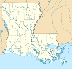
 Crooks MoundLocation within Louisiana today
Coordinates: 31°31′28.16″N 92°1′2.21″W / 31.5244889°N 92.0172806°W Location Country:  USA
USARegion: La Salle Parish, Louisiana Nearest town: Jonesville, Louisiana History Culture: Marksville culture First occupied: 100 BCE Period: Woodland period Abandoned: 400 CE Excavation and maintenance Responsible body: private Dates excavated: 1938-1939, Notable archaeologists: James A. Ford Architecture Architectural styles: Burial mound Crooks Mound (French: Monticule d'Escrocs) is a large Marksville culture mound site, located in La Salle Parish in south central Louisiana. It is a large, conical, burial mound that was part of at least six episodes of burials. It measured about 16 ft high (4.9 m) and 85 ft wide (26 m). It contained roughly 1,150 remains that were placed however they were able to be fit into the structure of the mound. Sometimes body parts were removed in order to achieve that goal. Archaeologists think it was a holding house for the area that was emptied periodically in order to achieve this type of setup.[1]
Most of the time, the people were just placed into the mound, but a few of the burials were in log-lined tombs or rarely stone lined tombs. Only a few out of each burial were interred with copper tools as grave goods. This suggests that the area was mainly for common people to be buried in.[1]
The site is on private land, usually with no public access but you are able to view it from the roadway.
Description
There were two separate mounds that make up the site. In 1938-1939 the site was completely excavated under the direction of James A. Ford. The mounds were 1,200 feet (370 m) southeast of French Fork Bayou and 450 feet (140 m) southwest of Cypress Bayou. Mound A was a conical mound that stood 21 feet high and 84 feet in diameter. Mound B was 2 feet (0.61 m) high and 50 feet (15 m) in diameter and located 110 feet (34 m) southwest of Mound A. Excavations revealed that Mound A had been built in three stages; Mound B was a single-stage structure. The mounds held 1,175 burials: 1,159 from Mound A, and 13 from Mound B (3 unknown). Pottery accompanied some burials; the weight of mound fill apparently crushed the vessels. The mounds were used for burials around 100 BCE to 400 CE. No evidence for domestic structures exists on or near the mounds, leading archaeologists to believe they were strictly for mortuary purposes.
Sources
- ^ a b "Tejas-Caddo Ancestors-Woodland cultures". University of Texas at Austin. http://www.texasbeyondhistory.net/tejas/ancestors/woodland.htm. Retrieved 2010-10-17.[dead link]
- Fagan, Brian M. Ancient North America 2005. Thames and Hudson. p. 408
 Hopewellian peoples
Woodland period · List of Hopewell sites · Mound builder (people) · List of archaeological periods (North America) Ohio Hopewell Beam Farm · Benham Mound · Cary Village Site · Cedar-Bank Works · Dunns Pond Mound · Ellis Mounds · Ety Enclosure · Ety Habitation Site · Fort Ancient · Fortified Hill Works · Great Hopewell Road · High Banks Works · Hopeton Earthworks · Hopewell Culture National Historical Park · Indian Mound Cemetery · Keiter Mound · Marietta Earthworks · Moorehead Circle · Mound of Pipes · Nettle Lake Mound Group · Newark Earthworks · Oak Mounds · Perin Village Site · Portsmouth Earthworks · Seip Earthworks and Dill Mounds District · Shawnee Lookout · Tremper Mound and Works · Williamson Mound Archeological District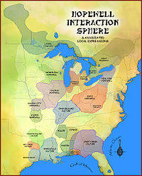
Crab Orchard culture Goodall Focus Goodall Site · Norton Mound GroupHavana Hopewell culture Kansas City Hopewell Marksville culture Miller culture Point Peninsula Complex Swift Creek culture Etowah Indian Mounds · Leake Mounds · Kolomoki Mounds Historic Park · Miner's Creek site, · Nacoochee Mound · Swift Creek mound site · Yearwood siteOther Hopewellian peoples Armstrong culture · Copena culture · Fourche Maline culture · Laurel Complex · Saugeen Complex · Old Stone Fort (Tennessee)Exotic trade items Related topics · Ancient Monuments of the Mississippi Valley · Black drink · burial mound · Calumet (pipe) · Effigy mound · Hopewell pottery · Horned Serpent · Eastern Agricultural Complex · Underwater panther Categories:- Marksville culture
- Archaeological sites in Louisiana
- Geography of La Salle Parish, Louisiana
- Louisiana geography stubs
- United States archaeology stubs


Wikimedia Foundation. 2010.