- Criggion radio station
-
 Criggion Radio Station in 2011
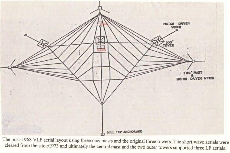
Criggion radio station was a transmitter site latterly operated by BT on behalf of the UK Ministry of Defence. It was located near the village of Criggion in the parish of Bausley with Criggion, which lies in the county of Powys, Wales. It was established in World War II as a back-up unit for Rugby radio station and took over the latter's traffic for a short period in 1943 following a fire at Rugby. Operating on 19.6kHz with the callsign GBZ, the station was used until its shutdown on April 1, 2003 for sending messages to submarines. This task (and that of Rugby) is now carried out by the Anthorn radio station. Criggion's VLF antenna was hung from three free-standing steel lattice towers (height 182.9 metres), two guyed masts (height: 213.4 metres) and a rock anchor. The towers and masts were demolished in August 2003 and there is now no visible evidence that a large radio station ever existed on the site.
Gallery
External links
- http://newsimg.bbc.co.uk/1/hi/wales/mid/3176253.stm
- http://www.subbrit.org.uk/sb-sites/sites/c/criggion_radio/index.shtml
- http://www.oswestry-history.co.uk/criggion-radio-station.html
- http://www.oswestry-history.co.uk/criggion/images/vlf-aerial-layout.jpg
- http://skyscraperpage.com/diagrams/?b61508
- http://skyscraperpage.com/diagrams/?b61510
Transmitter sites in Wales Transmitter stations Arfon · Carmel · Criggion · Ferryside · Flint · Haverfordwest · Kilvey Hill · Llanddona · Moel-y-Parc · Preseli · Wenvoe · Wrexham-Rhos
Categories:- Transmitter sites in Wales
- Buildings and structures in Powys
-


Wikimedia Foundation. 2010.