- Coyote Lake (San Bernardino County, California)
-
Coyote Lake 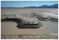
Location Mojave Desert
San Bernardino County, CaliforniaCoordinates 35°04′13″N 116°45′17″W / 35.0702°N 116.7547°WCoordinates: 35°04′13″N 116°45′17″W / 35.0702°N 116.7547°W Lake type Endorheic basin Primary outflows Terminal Basin countries United States Max. length 10 km (6.2 mi) Max. width 6 km (3.7 mi) Shore length1 30 km (19 mi) Surface elevation 515 m (1,690 ft) References U.S. Geological Survey Geographic Names Information System: Coyote Lake 1 Shore length is not a well-defined measure. Coyote Dry Lake is a dry lake bed in the Mojave Desert of San Bernardino County, California, 15 mi (24 km) northeast of Barstow. The lake is approximately 10 km (6.2 mi) by 6 km (3.7 mi) at its widest point.
Coyote Dry Lake lies to the south of Fort Irwin Military Reservation and southwest of the Tiefort Mountains. St Antony's Monastery is located about 4 mi (6.4 km) to the southeast.
Numerous meteorites have been found on the lake bed.[1]
References
- Allan, Stuart (2005). California Road and Recreation Atlas. Benchmark Maps. p. 96. ISBN 0929591801.
External links
- U.S. Geological Survey Geographic Names Information System: Coyote Lake (San Bernardino County, California)
- Satellite Photo (Google Maps)
Categories:- Endorheic lakes of California
- Salt flats of the United States
- Lakes of the Mojave Desert
- Natural history of the Mojave Desert
- Lakes of San Bernardino County, California
- San Bernardino County, California geography stubs

Wikimedia Foundation. 2010.