Gunderbooka County

Gunderbooka County
Gunderbooka
New South Wales
Gunderbooka NSW.PNG
Location in New South Wales
Lands administrative divisions around Gunderbooka
Irrara Culgoa Culgoa
Barrona Gunderbooka Narran
Landsborough Yanda Cowper

Gunderbooka County is one of the 141 Cadastral divisions of New South Wales. The Warrego River is the western boundary, and the Culgoa River and Darling River is the south-eastern boundary. It includes the area down to where the Warrego meets the Darling, to the north of Bourke (including North Bourke).

The Darling River is the boundary between Gunderbooka and Cowper.

Gunderbooka is believed to be derived from a local Aboriginal word and is also the name of Gundabook Station.[1]

Parishes within this county

A full list of parishes found within this county; their current LGA and mapping coordinates to the approximate centre of each location is as follows:

Parish LGA Coordinates
Aripilis Bourke Shire 30°17′04″S 145°30′52″E / 30.28444°S 145.51444°E / -30.28444; 145.51444 (Aripilis Parish)
Bibildoolie Bourke Shire 29°38′50″S 145°46′40″E / 29.64722°S 145.77778°E / -29.64722; 145.77778 (Bibildoolie Parish)
Booka Bourke Shire 30°04′00″S 145°27′42″E / 30.0666667°S 145.46167°E / -30.0666667; 145.46167 (Booka Parish)
Bothadoola Bourke Shire 30°02′43″S 145°34′43″E / 30.04528°S 145.57861°E / -30.04528; 145.57861 (Bothadoola Parish)
Boyong Bourke Shire 30°09′40″S 145°44′44″E / 30.16111°S 145.74556°E / -30.16111; 145.74556 (Boyong Parish)
Brandis Bourke Shire 29°53′49″S 145°57′50″E / 29.89694°S 145.96389°E / -29.89694; 145.96389 (Brandis Parish)
Bullamunta Bourke Shire 30°00′33″S 145°58′14″E / 30.00917°S 145.97056°E / -30.00917; 145.97056 (Bullamunta Parish)
Coolamon Bourke Shire 29°45′12″S 145°41′28″E / 29.75333°S 145.69111°E / -29.75333; 145.69111 (Coolamon Parish)
Cooning Bourke Shire 29°33′28″S 146°09′30″E / 29.55778°S 146.15833°E / -29.55778; 146.15833 (Cooning Parish)
Cooper Bourke Shire 29°49′55″S 145°44′16″E / 29.83194°S 145.73778°E / -29.83194; 145.73778 (Cooper Parish)
Courallie Bourke Shire 29°36′50″S 145°54′42″E / 29.61389°S 145.91167°E / -29.61389; 145.91167 (Courallie Parish)
Cumbooka Bourke Shire 29°42′53″S 146°17′55″E / 29.71472°S 146.29861°E / -29.71472; 146.29861 (Cumbooka Parish)
Cuttabulla Bourke Shire 29°28′28″S 145°57′10″E / 29.47444°S 145.95278°E / -29.47444; 145.95278 (Cuttabulla Parish)
Darling Bourke Shire 29°42′22″S 146°04′40″E / 29.70611°S 146.07778°E / -29.70611; 146.07778 (Darling Parish)
Fords Bridge Bourke Shire 29°50′53″S 145°29′45″E / 29.84806°S 145.49583°E / -29.84806; 145.49583 (Fords Bridge Parish)
Franklin Bourke Shire 30°06′25″S 145°40′43″E / 30.10694°S 145.67861°E / -30.10694; 145.67861 (Franklin Parish)
Galar Bourke Shire 29°43′23″S 145°44′43″E / 29.72306°S 145.74528°E / -29.72306; 145.74528 (Galar Parish)
Goldson Bourke Shire 29°49′12″S 146°02′52″E / 29.82°S 146.04778°E / -29.82; 146.04778 (Goldson Parish)
Greig Bourke Shire 29°51′28″S 145°57′58″E / 29.85778°S 145.96611°E / -29.85778; 145.96611 (Greig Parish)
Ledknapper Bourke Shire 29°35′32″S 146°13′26″E / 29.59222°S 146.22389°E / -29.59222; 146.22389 (Ledknapper Parish)
Leila Bourke Shire 29°29′33″S 145°48′26″E / 29.4925°S 145.80722°E / -29.4925; 145.80722 (Leila Parish)
Looden Bourke Shire 29°50′10″S 146°14′11″E / 29.83611°S 146.23639°E / -29.83611; 146.23639 (Looden Parish)
Mooramia Bourke Shire 29°49′41″S 145°52′20″E / 29.82806°S 145.87222°E / -29.82806; 145.87222 (Mooramia Parish)
Mumpber Bourke Shire 30°11′14″S 145°30′50″E / 30.18722°S 145.51389°E / -30.18722; 145.51389 (Mumpber Parish)
Mungunyah Bourke Shire 29°24′54″S 145°51′06″E / 29.415°S 145.85167°E / -29.415; 145.85167 (Mungunyah Parish)
Nellys Springs Bourke Shire 29°35′35″S 146°03′20″E / 29.59306°S 146.05556°E / -29.59306; 146.05556 (Nellys Springs Parish)
Nidgerie Bourke Shire 29°58′56″S 145°40′42″E / 29.98222°S 145.67833°E / -29.98222; 145.67833 (Nidgerie Parish)
North Bourke Bourke Shire 30°02′45″S 145°56′33″E / 30.04583°S 145.9425°E / -30.04583; 145.9425 (North Bourke Parish)
Nulty Bourke Shire 30°12′35″S 145°38′01″E / 30.20972°S 145.63361°E / -30.20972; 145.63361 (Nulty Parish)
Paka Bourke Shire 30°02′49″S 145°43′30″E / 30.04694°S 145.725°E / -30.04694; 145.725 (Paka Parish)
Palmer Bourke Shire 29°45′17″S 146°09′54″E / 29.75472°S 146.165°E / -29.75472; 146.165 (Palmer Parish)
Pera Bourke Shire 30°03′54″S 145°52′24″E / 30.065°S 145.87333°E / -30.065; 145.87333 (Pera Parish)
Polo Bourke Shire 29°58′45″S 145°47′09″E / 29.97917°S 145.78583°E / -29.97917; 145.78583 (Polo Parish)
Quondong Bourke Shire 29°46′02″S 146°25′59″E / 29.76722°S 146.43306°E / -29.76722; 146.43306 (Quondong Parish)
Sutherland Bourke Shire 29°53′48″S 145°37′33″E / 29.89667°S 145.62583°E / -29.89667; 145.62583 (Sutherland Parish)
Talaa Bourke Shire 30°00′33″S 145°52′02″E / 30.00917°S 145.86722°E / -30.00917; 145.86722 (Talaa Parish)
Tobin Bourke Shire unknown
Toorale Bourke Shire 30°16′40″S 145°25′30″E / 30.27778°S 145.425°E / -30.27778; 145.425 (Toorale Parish)
Tresillian Bourke Shire 29°46′22″S 145°53′50″E / 29.77278°S 145.89722°E / -29.77278; 145.89722 (Tresillian Parish)
Tully Bourke Shire 29°52′04″S 146°08′32″E / 29.86778°S 146.14222°E / -29.86778; 146.14222 (Tully Parish)
Turee Bourke Shire 29°54′43″S 146°06′02″E / 29.91194°S 146.10056°E / -29.91194; 146.10056 (Turee Parish)
Warraweena Bourke Shire 29°55′33″S 146°15′56″E / 29.92583°S 146.26556°E / -29.92583; 146.26556 (Warraweena Parish)
Wommera Bourke Shire 29°57′01″S 145°35′47″E / 29.95028°S 145.59639°E / -29.95028; 145.59639 (Wommera Parish)
Yarraman Bourke Shire 29°40′53″S 146°21′15″E / 29.68139°S 146.35417°E / -29.68139; 146.35417 (Yarraman Parish)
Yurongan Bourke Shire 29°37′19″S 146°13′29″E / 29.62194°S 146.22472°E / -29.62194; 146.22472 (Yurongan Parish)

References

  1. ^ Geographical Names Board of NSW[dead link]

Wikimedia Foundation. 2010.

Игры ⚽ Нужна курсовая?

Look at other dictionaries:

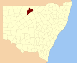
  • Gunderbooka County, New South Wales — Infobox Australian cadastral name = Gunderbooka state = New South Wales caption = Location in New South Wales near nw = Irrara near n = Culgoa near ne = Culgoa near e = Narran near se = Cowper near s = Yanda near sw = Landsborough near w =… …   Wikipedia

  • Cowper County — Cowper New South Wales Location in New South Wales Lands administrative divisions around Cowper …   Wikipedia

  • Cowper County, New South Wales — Infobox Australian cadastral name = Cowper state = New South Wales caption = Location in New South Wales near nw = Gunderbooka near n = Gunderbooka near ne = Clyde near e = Clyde near se = Canbelego near s = Robinson near sw = Yanda near w =… …   Wikipedia

  • Barrona County, New South Wales — Infobox Australian cadastral name = Barrona state = New South Wales caption = Location in New South Wales near nw = Thoulcanna near n = Irrara near ne = Gunderbooka near w = Ularara near e = Gunderbooka near sw = Fitzgerald near s = Landsborough… …   Wikipedia

  • Barrona County — Map of all coordinates from Google Map of all coordinates from Bing Export all coordinates as KML …   Wikipedia

  • Landsborough County, New South Wales — Infobox Australian cadastral name = Landsborough state = New South Wales caption = Location in New South Wales near nw = Ularara near n = Barrona near ne = Gunderbooka near e = Gunderbooka near se = Yanda near s = Rankin near sw = Killara near w …   Wikipedia

  • Landsborough County — Map of all coordinates from Google Map of all coordinates from Bing Export all coordinates as KML …   Wikipedia

  • Culgoa County, New South Wales — Infobox Australian cadastral name = Culgoa state = New South Wales caption = Location in New South Wales near nw = Queensland near n = Queensland near ne = Queensland near e = Narran near se = Narran near s = Gunderbooka near sw = Gunderbooka… …   Wikipedia

  • Culgoa County — Map of all coordinates from Google Map of all coordinates from Bing Export all coordinates as KML …   Wikipedia

  • Clyde County, New South Wales — Infobox Australian cadastral name = Clyde state = New South Wales caption = Location in New South Wales near nw = Gunderbooka near n = Narran near ne = Finch near e = Leichardt near se = Gregory near s = Canbelego near sw = Cowper near w =… …   Wikipedia

Share the article and excerpts

Direct link
Do a right-click on the link above
and select “Copy Link”