Benarba County

Benarba County
Benarba
New South Wales
Benarba NSW.PNG
Location in New South Wales
Lands administrative divisions around Benarba
Queensland Queensland Stapylton
Finch Benarba Courallie
Denham Jamison Courallie

Benarba County is one of the 141 Cadastral divisions of New South Wales.

Benarba is believed to be derived from a local Aboriginal word.[1]

Parishes within this county

A full list of parishes found within this county; their current LGA and mapping coordinates to the approximate centre of each location is as follows:

Parish LGA Coordinates
Balerang Moree Plains Shire 29°01′54″S 149°25′04″E / 29.03167°S 149.41778°E / -29.03167; 149.41778 (Balerang)
Ballalla Moree Plains Shire 29°04′54″S 149°19′04″E / 29.08167°S 149.31778°E / -29.08167; 149.31778 (Ballalla)
Banarway Moree Plains Shire 29°18′54″S 148°45′04″E / 29.315°S 148.75111°E / -29.315; 148.75111 (Banarway)
Baroona Moree Plains Shire 29°11′54″S 149°31′04″E / 29.19833°S 149.51778°E / -29.19833; 149.51778 (Baroona)
Bibble Moree Plains Shire 29°06′54″S 148°50′04″E / 29.115°S 148.83444°E / -29.115; 148.83444 (Bibble)
Biroo Moree Plains Shire 29°17′54″S 149°00′04″E / 29.29833°S 149.00111°E / -29.29833; 149.00111 (Biroo)
Boolmuckledi Moree Plains Shire 29°03′54″S 149°15′04″E / 29.065°S 149.25111°E / -29.065; 149.25111 (Boolmuckledi)
Boomi Moree Plains Shire 28°42′54″S 149°23′04″E / 28.715°S 149.38444°E / -28.715; 149.38444 (Boomi)
Boonaldoon Moree Plains Shire 29°29′04″S 149°24′48″E / 29.48444°S 149.41333°E / -29.48444; 149.41333 (Boonaldoon)
Boonangar Moree Plains Shire 28°38′54″S 149°32′04″E / 28.64833°S 149.53444°E / -28.64833; 149.53444 (Boonangar)
Boonerey Moree Plains Shire 29°11′54″S 148°52′04″E / 29.19833°S 148.86778°E / -29.19833; 148.86778 (Boonerey)
Boonoona Moree Plains Shire 29°10′54″S 149°36′04″E / 29.18167°S 149.60111°E / -29.18167; 149.60111 (Boonoona)
Boronga Moree Plains Shire 28°46′54″S 149°40′04″E / 28.78167°S 149.66778°E / -28.78167; 149.66778 (Boronga)
Boroo Moree Plains Shire 28°47′54″S 149°14′04″E / 28.79833°S 149.23444°E / -28.79833; 149.23444 (Boroo)
Boyanga Moree Plains Shire 29°09′54″S 149°14′04″E / 29.165°S 149.23444°E / -29.165; 149.23444 (Boyanga)
Brigalow Moree Plains Shire 28°56′54″S 149°32′04″E / 28.94833°S 149.53444°E / -28.94833; 149.53444 (Brigalow)
Bucknel Moree Plains Shire 29°00′54″S 149°01′04″E / 29.015°S 149.01778°E / -29.015; 149.01778 (Bucknel)
Bunarba Moree Plains Shire 29°00′54″S 149°13′04″E / 29.015°S 149.21778°E / -29.015; 149.21778 (Bunarba)
Bundori Moree Plains Shire 28°42′54″S 149°28′04″E / 28.715°S 149.46778°E / -28.715; 149.46778 (Bundori)
Bunna Bunna Narrabri Shire 29°45′54″S 149°14′04″E / 29.765°S 149.23444°E / -29.765; 149.23444 (Bunna Bunna)
Burragillo Moree Plains Shire 29°27′54″S 149°09′04″E / 29.465°S 149.15111°E / -29.465; 149.15111 (Burragillo)
Burrandoon Moree Plains Shire 29°24′54″S 149°08′04″E / 29.415°S 149.13444°E / -29.415; 149.13444 (Burrandoon)
Caidmurra Moree Plains Shire 29°13′54″S 148°47′04″E / 29.23167°S 148.78444°E / -29.23167; 148.78444 (Caidmurra)
Carbeenbri Moree Plains Shire 29°34′54″S 149°17′04″E / 29.58167°S 149.28444°E / -29.58167; 149.28444 (Carbeenbri)
Carraa Moree Plains Shire 29°01′54″S 149°36′04″E / 29.03167°S 149.60111°E / -29.03167; 149.60111 (Carraa)
Collymongle Moree Plains Shire 29°26′54″S 148°44′04″E / 29.44833°S 148.73444°E / -29.44833; 148.73444 (Collymongle)
Collyu Moree Plains Shire 29°09′54″S 149°08′04″E / 29.165°S 149.13444°E / -29.165; 149.13444 (Collyu)
Cook Walgett Shire 29°35′54″S 148°44′04″E / 29.59833°S 148.73444°E / -29.59833; 148.73444 (Cook)
Cooloobong Moree Plains Shire 28°50′54″S 149°40′04″E / 28.84833°S 149.66778°E / -28.84833; 149.66778 (Cooloobong)
Coonalgra Moree Plains Shire 29°13′54″S 149°03′04″E / 29.23167°S 149.05111°E / -29.23167; 149.05111 (Coonalgra)
Coubal Moree Plains Shire 28°55′54″S 149°26′04″E / 28.93167°S 149.43444°E / -28.93167; 149.43444 (Coubal)
Cowmerton Moree Plains Shire 28°49′54″S 149°27′04″E / 28.83167°S 149.45111°E / -28.83167; 149.45111 (Cowmerton)
Crinoline Moree Plains Shire 29°13′54″S 149°08′04″E / 29.23167°S 149.13444°E / -29.23167; 149.13444 (Crinoline)
Cudgildool Moree Plains Shire 29°22′54″S 149°25′04″E / 29.38167°S 149.41778°E / -29.38167; 149.41778 (Cudgildool)
Currah Moree Plains Shire 28°55′54″S 149°22′04″E / 28.93167°S 149.36778°E / -28.93167; 149.36778 (Currah)
Currotha Moree Plains Shire 29°34′54″S 149°02′04″E / 29.58167°S 149.03444°E / -29.58167; 149.03444 (Currotha)
Currygundi Moree Plains Shire 29°13′54″S 149°15′04″E / 29.23167°S 149.25111°E / -29.23167; 149.25111 (Currygundi)
Dangar Walgett Shire 29°37′54″S 148°50′04″E / 29.63167°S 148.83444°E / -29.63167; 148.83444 (Dangar)
Derra Moree Plains Shire 29°28′54″S 149°13′04″E / 29.48167°S 149.21778°E / -29.48167; 149.21778 (Derra)
Dindierna Moree Plains Shire 28°54′54″S 149°13′04″E / 28.915°S 149.21778°E / -28.915; 149.21778 (Dindierna)
Direlmabildi Moree Plains Shire 29°20′54″S 149°09′04″E / 29.34833°S 149.15111°E / -29.34833; 149.15111 (Direlmabildi)
Doorabeeba Moree Plains Shire 29°46′54″S 149°23′04″E / 29.78167°S 149.38444°E / -29.78167; 149.38444 (Doorabeeba)
Dundunga Moree Plains Shire 29°09′54″S 149°03′04″E / 29.165°S 149.05111°E / -29.165; 149.05111 (Dundunga)
Galloway Moree Plains Shire 29°05′54″S 149°01′04″E / 29.09833°S 149.01778°E / -29.09833; 149.01778 (Galloway)
Gil Gil Moree Plains Shire 29°05′54″S 149°10′04″E / 29.09833°S 149.16778°E / -29.09833; 149.16778 (Gil Gil)
Gin Moree Plains Shire 29°19′54″S 149°15′04″E / 29.33167°S 149.25111°E / -29.33167; 149.25111 (Gin)
Gingham Moree Plains Shire 29°14′54″S 149°21′04″E / 29.24833°S 149.35111°E / -29.24833; 149.35111 (Gingham)
Goocalla Moree Plains Shire 29°06′54″S 149°24′04″E / 29.115°S 149.40111°E / -29.115; 149.40111 (Goocalla)
Gorman Walgett Shire 29°42′54″S 148°55′04″E / 29.715°S 148.91778°E / -29.715; 148.91778 (Gorman)
Greaves Moree Plains Shire 28°55′54″S 149°36′04″E / 28.93167°S 149.60111°E / -28.93167; 149.60111 (Greaves)
Greenaway Moree Plains Shire 29°27′54″S 148°50′04″E / 29.465°S 148.83444°E / -29.465; 148.83444 (Greenaway)
Gunathera Moree Plains Shire 29°28′54″S 148°52′04″E / 29.48167°S 148.86778°E / -29.48167; 148.86778 (Gunathera)
Hamilton Moree Plains Shire 28°50′54″S 149°10′04″E / 28.84833°S 149.16778°E / -28.84833; 149.16778 (Hamilton)
Hill Moree Plains Shire 29°34′54″S 148°57′04″E / 29.58167°S 148.95111°E / -29.58167; 148.95111 (Hill)
Kamilaroi Walgett Shire 29°31′54″S 148°41′04″E / 29.53167°S 148.68444°E / -29.53167; 148.68444 (Kamilaroi)
Keelo Moree Plains Shire 29°23′54″S 148°44′04″E / 29.39833°S 148.73444°E / -29.39833; 148.73444 (Keelo)
Krui Moree Plains Shire 29°41′54″S 149°24′04″E / 29.69833°S 149.40111°E / -29.69833; 149.40111 (Krui)
Kunopia Moree Plains Shire 28°41′54″S 149°36′04″E / 28.69833°S 149.60111°E / -28.69833; 149.60111 (Kunopia)
Mallowa Moree Plains Shire 29°34′54″S 149°07′04″E / 29.58167°S 149.11778°E / -29.58167; 149.11778 (Mallowa)
Markham Narrabri Shire 29°44′54″S 149°08′04″E / 29.74833°S 149.13444°E / -29.74833; 149.13444 (Markham)
Meei Moree Plains Shire 29°29′54″S 148°48′04″E / 29.49833°S 148.80111°E / -29.49833; 148.80111 (Meei)
Meero Moree Plains Shire 29°24′54″S 149°15′04″E / 29.415°S 149.25111°E / -29.415; 149.25111 (Meero)
Meroe Moree Plains Shire 29°24′54″S 149°15′04″E / 29.415°S 149.25111°E / -29.415; 149.25111 (Meroe)
Millebee Moree Plains Shire 29°39′54″S 149°15′04″E / 29.665°S 149.25111°E / -29.665; 149.25111 (Millebee)
Mongyer Moree Plains Shire 29°35′54″S 149°12′04″E / 29.59833°S 149.20111°E / -29.59833; 149.20111 (Mongyer)
Moomin Moree Plains Shire 29°39′54″S 149°07′04″E / 29.665°S 149.11778°E / -29.665; 149.11778 (Moomin)
Moorina Moree Plains Shire 29°08′54″S 149°31′04″E / 29.14833°S 149.51778°E / -29.14833; 149.51778 (Moorina)
Mungi Moree Plains Shire 29°38′54″S 149°02′04″E / 29.64833°S 149.03444°E / -29.64833; 149.03444 (Mungi)
Myall Moree Plains Shire 29°17′54″S 148°50′04″E / 29.29833°S 148.83444°E / -29.29833; 148.83444 (Myall)
Narrawall Moree Plains Shire 29°03′54″S 149°06′04″E / 29.065°S 149.10111°E / -29.065; 149.10111 (Narrawall)
Neargo Moree Plains Shire 29°24′54″S 149°03′04″E / 29.415°S 149.05111°E / -29.415; 149.05111 (Neargo)
Newcastle Moree Plains Shire 28°45′54″S 149°32′04″E / 28.765°S 149.53444°E / -28.765; 149.53444 (Newcastle)
Noonah Moree Plains Shire 29°11′54″S 149°24′04″E / 29.19833°S 149.40111°E / -29.19833; 149.40111 (Noonah)
Noora Moree Plains Shire 28°37′54″S 149°30′04″E / 28.63167°S 149.50111°E / -28.63167; 149.50111 (Noora)
Numby Numby Moree Plains Shire 29°19′54″S 149°04′04″E / 29.33167°S 149.06778°E / -29.33167; 149.06778 (Numby Numby)
Oreel Walgett Shire 29°44′54″S 149°02′04″E / 29.74833°S 149.03444°E / -29.74833; 149.03444 (Oreel)
Pearse Moree Plains Shire 29°22′54″S 148°52′04″E / 29.38167°S 148.86778°E / -29.38167; 148.86778 (Pearse)
Pially Moree Plains Shire 29°37′54″S 148°54′04″E / 29.63167°S 148.90111°E / -29.63167; 148.90111 (Pially)
Single Moree Plains Shire 29°34′54″S 149°24′04″E / 29.58167°S 149.40111°E / -29.58167; 149.40111 (Single)
Tala Moree Plains Shire 29°00′54″S 149°20′04″E / 29.015°S 149.33444°E / -29.015; 149.33444 (Tala)
Tellaraga Moree Plains Shire 29°31′54″S 149°25′04″E / 29.53167°S 149.41778°E / -29.53167; 149.41778 (Tellaraga)
Tiela Moree Plains Shire 29°23′54″S 149°20′04″E / 29.39833°S 149.33444°E / -29.39833; 149.33444 (Tiela)
Tillaloo Moree Plains Shire 29°13′54″S 149°26′04″E / 29.23167°S 149.43444°E / -29.23167; 149.43444 (Tillaloo)
Turrawah Moree Plains Shire 29°00′54″S 149°07′04″E / 29.015°S 149.11778°E / -29.015; 149.11778 (Turrawah)
Tycawina Moree Plains Shire 28°37′54″S 149°37′04″E / 28.63167°S 149.61778°E / -28.63167; 149.61778 (Tycawina)
Tyrrell Moree Plains Shire 28°46′54″S 149°37′04″E / 28.78167°S 149.61778°E / -28.78167; 149.61778 (Tyrrell)
Umbri Moree Plains Shire 28°51′54″S 149°10′04″E / 28.865°S 149.16778°E / -28.865; 149.16778 (Umbri)
Uranbah Moree Plains Shire 29°39′54″S 149°10′04″E / 29.665°S 149.16778°E / -29.665; 149.16778 (Uranbah)
Wadden Moree Plains Shire 29°00′54″S 149°31′04″E / 29.015°S 149.51778°E / -29.015; 149.51778 (Wadden)
Wandoona Moree Plains Shire 29°19′54″S 149°21′04″E / 29.33167°S 149.35111°E / -29.33167; 149.35111 (Wandoona)
Warren Moree Plains Shire 29°13′54″S 149°12′04″E / 29.23167°S 149.20111°E / -29.23167; 149.20111 (Warren)
Werrina Moree Plains Shire 28°43′54″S 149°18′04″E / 28.73167°S 149.30111°E / -28.73167; 149.30111 (Werrina)
Whalan Moree Plains Shire 28°50′54″S 149°34′04″E / 28.84833°S 149.56778°E / -28.84833; 149.56778 (Whalan)
Willalee Moree Plains Shire 29°28′54″S 149°02′04″E / 29.48167°S 149.03444°E / -29.48167; 149.03444 (Willalee)
Winslow Moree Plains Shire 28°48′54″S 149°22′04″E / 28.815°S 149.36778°E / -28.815; 149.36778 (Winslow)
Wirra North Moree Plains Shire 29°23′54″S 149°00′04″E / 29.39833°S 149.00111°E / -29.39833; 149.00111 (Wirra North)
Wirrir South Moree Plains Shire 29°28′54″S 148°57′04″E / 29.48167°S 148.95111°E / -29.48167; 148.95111 (Wirrir South)
Wirrit Moree Plains Shire 29°19′54″S 149°26′04″E / 29.33167°S 149.43444°E / -29.33167; 149.43444 (Wirrit)
Wolongimba Moree Plains Shire 29°41′54″S 149°19′04″E / 29.69833°S 149.31778°E / -29.69833; 149.31778 (Wolongimba)
Yarouah Moree Plains Shire 29°01′54″S 149°03′04″E / 29.03167°S 149.05111°E / -29.03167; 149.05111 (Yarouah)
Yarrol Moree Plains Shire 29°09′54″S 149°18′04″E / 29.165°S 149.30111°E / -29.165; 149.30111 (Yarrol)
Young Moree Plains Shire 29°12′54″S 149°01′04″E / 29.215°S 149.01778°E / -29.215; 149.01778 (Young)

References


Wikimedia Foundation. 2010.

Игры ⚽ Поможем решить контрольную работу

Look at other dictionaries:

  • Benarba County, New South Wales — Infobox Australian cadastral name = Benarba state = New South Wales caption = Location in New South Wales near nw = Queensland near n = Queensland near ne = Stapylton near w = Finch near e = Courallie near sw = Denham near s = Jamison near se =… …   Wikipedia

  • County of Belmore — Belmore Queensland Location within Queensland Lands administrative divisions around Belmore …   Wikipedia

  • Jamison County, New South Wales — Infobox Australian cadastral name = Jamison state = New South Wales caption = Location in New South Wales near nw = Benarba near n = Benarba near ne = Courallie near e = Murchison near se = Nandewar near s = White near sw = Baradine near w =… …   Wikipedia

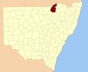
  • Stapylton County, New South Wales — Infobox Australian cadastral name = Stapylton state = New South Wales caption = Location in New South Wales near nw = Queensland near n = Queensland near ne = Queensland near e = Arrawatta near se = Burnett near s = Courallie near sw = Benarba… …   Wikipedia

  • Jamison County — Map of all coordinates from Google Map of all coordinates from Bing Export all coordinates as KML …   Wikipedia

  • Courallie County, New South Wales — Infobox Australian cadastral name = Courallie state = New South Wales caption = Location in New South Wales near nw = Benarba near n = Stapylton near ne = Burnett near e = Burnett near se = Murchison near s = Jamison near sw = Jamison near w =… …   Wikipedia

  • Stapylton County — Map of all coordinates from Google Map of all coordinates from Bing Export all coordinates as KML …   Wikipedia

  • Courallie County — Map of all coordinates from Google Map of all coordinates from Bing Export all coordinates as KML …   Wikipedia

  • Denham County, New South Wales — Infobox Australian cadastral name = Denham state = New South Wales caption = Location in New South Wales near nw = Finch near n = Finch near ne = Benarba near e = Jamison near se = Baradine near s = Baradine near sw = Baradine near w =… …   Wikipedia

  • Finch County, New South Wales — Infobox Australian cadastral name = Finch state = New South Wales caption = Location in New South Wales near nw = Queensland near n = Queensland near ne = Queensland near e = Benarba near se = Denham near s = Leichardt near sw = Clyde near w =… …   Wikipedia

Share the article and excerpts

Direct link
Do a right-click on the link above
and select “Copy Link”