- Cotriguaçu
-
Cotriguaçu — Municipality and town — Country  Brazil
Region Center-West State Mato Grosso Mesoregion Norte Mato-Grossense Time zone UTC -3 Cotriguaçu is a town and municipality in the state of Mato Grosso in the Central-West Region of Brazil.[1][2][3][4]
See also
References
- ^ "Divisão Territorial do Brasil" (in Portuguese). Divisão Territorial do Brasil e Limites Territoriais, Instituto Brasileiro de Geografia e Estatística (IBGE). July 1, 2008. ftp://geoftp.ibge.gov.br/Organizacao/Divisao_Territorial/2008/DTB_2008.zip. Retrieved December 17, 2009.
- ^ "Estimativas da população para 1º de julho de 2009" (in Portuguese) (PDF). Estimativas de População, Instituto Brasileiro de Geografia e Estatística (IBGE). August 14, 2009. http://www.ibge.gov.br/home/estatistica/populacao/estimativa2009/POP2009_DOU.pdf. Retrieved December 17, 2009.
- ^ "Ranking decrescente do IDH-M dos municípios do Brasil" (in Portuguese). Atlas do Desenvolvimento Humano, Programa das Nações Unidas para o Desenvolvimento (PNUD). 2000. http://www.pnud.org.br/atlas/ranking/IDH-M%2091%2000%20Ranking%20decrescente%20(pelos%20dados%20de%202000).htm. Retrieved December 17, 2009.
- ^ "Produto Interno Bruto dos Municípios 2002-2005" (in Portuguese). Instituto Brasileiro de Geografia e Estatística (IBGE). December 19, 2007. http://www.ibge.gov.br/home/estatistica/economia/pibmunicipios/2005/tab01.pdf. Retrieved December 17, 2009.
Municipalities of Mato Grosso Capital: CuiabáCentro-Sul Mato-Grossense Alto PantanalBarão de Melgaço • Cáceres • Curvelândia • PoconéAlto ParaguaiAlto Paraguai • Arenápolis • Nortelândia • Nova Marilândia • Santo AfonsoCuiabáChapada dos Guimarães • Cuiabá • Nossa Senhora do Livramento • Santo Antônio do Leverger • Várzea GrandeRosario OesteAcorizal • Jangada • Rosário Oeste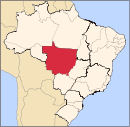
Nordeste Mato-Grossense CanaranaÁgua Boa • Campinápolis • Canarana • Nova Nazaré • Nova Xavantina • Novo São Joaquim • Querência • Santo Antônio do LesteMedio AraguaiaAraguaiana • Barra do Garças • CocalinhoNorte AraguaiaAlto Boa Vista • Bom Jesus do Araguaia • Canabrava do Norte • Confresa • Luciára • Novo Santo Antônio • Porto Alegre do Norte • Ribeirão Cascalheira • Santa Cruz do Xingu • Santa Terezinha • São Félix do Araguaia • São José do Xingu • Serra Nova Dourada • Vila RicaNorte Mato-Grossense Alta FlorestaAlto Teles PiresIpiranga do Norte • Itanhangá • Lucas do Rio Verde • Nobres • Nova Mutum • Nova Ubiratã • Santa Rita do Trivelato • Sorriso • TapurahArinosJuara • Nova Maringá • Novo Horizonte do Norte • Porto dos Gaúchos • São José do Rio Claro • TabaporãAripuanãColíderColíder • Guaranta do Norte • Matupá • Nova Canaã do Norte • Nova Guarita • Novo Mundo • Peixoto de Azevedo • Terra Nova do NorteParanatingaGaúcha do Norte • Nova Brasilândia • Paranatinga • Planalto da SerraParecisComodoro • Campo Novo do Parecis • Campos de Júlio • Diamantino • SapezalSinopCláudia • Feliz Natal • Itaúba • Marcelândia • Nova Santa Helena • Santa Carmem • Sinop • União do Sul • VeraSudeste Mato-Grossense Alto AraguaiaAlto Araguaia • Alto Garças • Alto TaquariPrimavera do LesteCampo Verde • Primavera do LesteRondonópolisDom Aquino • Itiquira • Jaciara • Juscimeira • Pedra Preta • Rondonópolis • São José do Povo • São Pedro da CipaTesouroAraguainha • General Carneiro • Guiratinga • Pontal do Araguaia • Ponte Branca • Poxoréo • Ribeirãozinho • Tesouro • TorixoréuSudoeste Mato-Grossense Alto GuaporeConquista d'Oeste • Nova Lacerda • Pontes e Lacerda • Vale de São Domingos • Vila Bela da Santíssima TrindadeJauruAraputanga • Figueirópolis d'Oeste • Glória d'Oeste • Indiavaí • Jauru • Lambari d'Oeste • Mirassol d'Oeste • Porto Esperidião • Reserva do Cabaçal • Rio Branco • Salto do Céu • São José dos Quatro MarcosTangará da SerraBarra do Bugres • Denise • Nova Olímpia • Porto Estrela • Tangará da SerraCategories:- Municipalities of Brazil
- Mato Grosso geography stubs
- Populated places in Mato Grosso

Wikimedia Foundation. 2010.