- Cootamundra Shire
-
Cootamundra Shire
New South Wales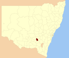
Location in New South WalesPopulation: 7,703(2009)[1] Area: 1524 km² (588.4 sq mi) Mayor: Paul Braybrooks Council Seat: Cootamundra (Wallendoon Street)[2] Region: South West Slopes State District: Burrinjuck Federal Division: Hume LGAs around Cootamundra Shire: Temora Young Young Temora Cootamundra Shire Harden Junee Gundagai Gundagai Cootamundra Shire is a local government area in New South Wales, Australia. It is on the Olympic Way, the Burley Griffin Way and the Main South railway line.
The Shire includes the town of Cootamundra and the small towns of Stockinbingal, Brawlin and Wallendbeen.
Council
Cootamundra Shire Council is composed of nine councillors elected proportionally. The mayor is not directly elected.[3] The current makeup of the council is as follows:[3]
Party Councillors Independents and Unaffiliated 9 Total 9 The current council, elected in 2008, is:[3]
Councillor Party Notes Doug Phillips Unaffiliated Paul Braybrooks Unaffiliated Mayor Simon Sutherland Unaffiliated James Slattery Independent Allan Smith Unaffiliated Marie Holt Unaffiliated Bruce Smith Unaffiliated Deputy Mayor Dennis Palmer Independent Mary Donnelly Independent References
- ^ Australian Bureau of Statistics (30 March 2010). "Regional Population Growth, Australia, 2008–09". http://www.abs.gov.au/ausstats/abs@.nsf/Latestproducts/3218.0Main%20Features42008-09?opendocument&tabname=Summary&prodno=3218.0&issue=2008-09&num=&view=. Retrieved 3 June 2010.
- ^ "Cootamundra Shire Council". Department of Local Government. http://www.dlg.nsw.gov.au/dlg/dlghome/dlg_CouncilContactDetails.asp?slacode=2200. Retrieved 2006-11-07.
- ^ a b c "Cootamundra Council". 2008 Election results. Electoral Commission NSW. http://www.lg.elections.nsw.gov.au/LGE2008/result.Cootamundra.html. Retrieved 2009-06-16.[dead link]
Coordinates: 34°39′S 148°02′E / 34.65°S 148.033°E
Local Government Areas of the Riverina Cities: Albury · Griffith · Wagga Wagga
Towns: Deniliquin
Shires: Balranald · Berrigan · Carrathool · Conargo · Coolamon · Cootamundra · Corowa · Greater Hume · Gundagai · Hay · Jerilderie · Junee · Leeton · Lockhart · Murray · Murrumbidgee · Narrandera · Temora · Tumbarumba · Tumut · Urana · Wakool
Local Government Areas of New South Wales Metropolitan Sydney Inner SydneyAshfield · Botany Bay · Burwood · Canada Bay · Canterbury · Hurstville · Kogarah · Lane Cove · Leichhardt · Manly · Marrickville · Mosman · North Sydney · Randwick · Rockdale · Strathfield · Sydney · Waverley · Willoughby · WoollahraOuter SydneyAuburn · Bankstown · Blacktown · Camden · Campbelltown · Fairfield · The Hills · Holroyd · Hornsby · Hunter's Hill · Ku-ring-gai · Liverpool · Parramatta · Penrith · Pittwater · Ryde · Sutherland · WarringahSydney SurroundsMid North Coast Bellingen · Clarence Valley · Coffs Harbour · Greater Taree · Kempsey · Nambucca · Port Macquarie-Hastings · Lord Howe IslandMurray Murrumbidgee Carrathool · Coolamon · Cootamundra · Griffith · Gundagai · Hay · Junee · Leeton · Lockhart · Murrumbidgee · Narrandera · Temora · Wagga WaggaHunter Cessnock · Dungog · Gloucester · Great Lakes · Lake Macquarie · Maitland · Muswellbrook · Newcastle · Port Stephens · Singleton · Upper HunterIllawarra Richmond Tweed Southeastern Bega · Bombala · Boorowa · Cooma-Monaro · Eurobodalla · Goulburn Mulwaree · Harden · Palerang · Queanbeyan · Snowy River · Tumut · Upper Lachlan · Yass Valley · YoungNorthern Armadale Dumaresq · Glen Innes-Severn · Gunnedah · Guyra · Gwydir · Inverell · Liverpool Plains · Moree Plains · Narrabri · Tamworth · Tenterfield · Uralla · WalchaCentral West North Western Far West Categories:- Local Government Areas of New South Wales
- Local Government Areas of the Riverina, New South Wales
- Riverina geography stubs

Wikimedia Foundation. 2010.