- Scattered Islands in the Indian Ocean
-
Scattered Islands in the Indian Ocean Îles éparses de l'océan indien
Motto: Liberté, égalité, fraternité Anthem: La Marseillaise 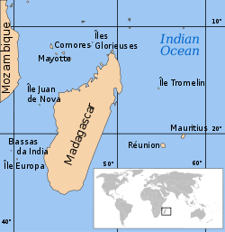 Location of the Scattered Islands in the Indian Ocean:
• 1 : Bassas da India • 2 : Europa Island • 3 : Glorioso Islands • 4 : Juan de Nova Island • 5 : Tromelin Island
(KM : Comoros, MG : Madagascar, MU : Mauritius, MZ : Mozambique, RE : Réunion, YT : Mayotte)
This article is part of the series on
Administrative divisions of France(incl. overseas regions)
(incl. overseas departments)
Urban communities
Agglomeration communities
Commune communities
Syndicates of New AgglomerationOthers in Overseas FranceOverseas collectivities
Sui generis collectivity
Overseas country
Overseas territory
Clipperton IslandThe Scattered Islands in the Indian Ocean (French: Îles Éparses or Îles éparses de l'océan indien) consist of four small coral islands, an atoll, and a reef in the Indian Ocean, and have constituted the 5th district of the French Southern and Antarctic Lands (TAAF) since February 2007.[1] They have no permanent population. Three of the islands — the Glorioso Islands, Juan de Nova and Europa — and the Bassas da India atoll lie in the Mozambique Channel west of Madagascar, while the fourth island, Tromelin, lies about 450 kilometres (280 mi) east of Madagascar. Also in the Mozambique Channel is the Banc du Geyser, a reef which was annexed by Madagascar in 1976. France continues to view the Banc du Geyser as part of the Îles Éparses.[citation needed]
The islands have been classified as nature reserves. Except for Bassas da India, they all support meteorological stations: those on the Glorioso Islands, Juan de Nova and Europa Island are automated. The station on Tromelin Island, in particular, provides warning of cyclones threatening Madagascar, Réunion or Mauritius. Each of the islands, except Bassas da India and Banc du Geyser, has an airstrip of more than 1,000 metres (3,300 ft). Mauritius, the Comoros, Seychelles, and Madagascar dispute France's sovereignty over the islands. Mauritius claims Tromelin; the Comoros and Seychelles claim the Glorioso Islands; the Comoros and Madagascar claim Banc du Geyser; and Madagascar claims[2] the remaining islands.
Contents
Overview
Atoll/Island Station
StaffArea
km²Lagoon
km²EEZ
km²Coordinates Location Banc du Geyser - N/A N/A N/A 12°21′S 46°26′E / 12.35°S 46.433°E North Mozambique Channel Glorioso Islands 11 5 29.6 48350 11°33′S 47°20′E / 11.55°S 47.333°E North Mozambique Channel Juan de Nova Island 14 4.4 (1) 61050 17°03′S 42°45′E / 17.05°S 42.75°E Central Mozambique Channel Bassas da India - 0.2 79.8 123700 21°27′S 39°45′E / 21.45°S 39.75°E South Mozambique Channel Europa Island 12 28 9 127300 22°20′S 40°22′E / 22.333°S 40.367°E South Mozambique Channel Tromelin Island 19 0.8 - 280000 15°53′S 54°31′E / 15.883°S 54.517°E Western Indian Ocean Total 56 38.6 118.4 640400 Individual islands
- Banc du Geyser
- Bassas da India
- Ten unnamed rock islets
- Europa Island
- Île Europa
- Eight unnamed rock islets
- Glorioso Islands
- Grande Glorieuse
- Île du Lys
- Wreck Rock
- South Rock
- Verte Rocks (three islets)
- Three unnamed islets
- Juan de Nova Island
- Tromelin Island
Administration
Since January 3, 2005, the Îles Éparses have been administered on behalf of the French state by the senior administrator of the French Southern and Antarctic Lands (TAAF — les Terres Australes et Antartiques Françaises), based in Réunion. The Îles Éparses had previously been under the administration of the prefect of Réunion since the independence of Madagascar in 1960. France maintains a military garrison of around 14 troops on each of the islands in the Mozambique Channel that are claimed by Madagascar. The Glorioso Islands are also claimed by the Comoros, while Mauritius claims Tromelin Island.
France claims an Exclusive Economic Zone (EEZ) of 200 nautical miles (370 km) around each of the small islands in the Îles Éparses, which together with the EEZ claims for the islands of Réunion and Mayotte totals more than one million square kilometres (400,000 sq mi) in the western Indian Ocean. There is considerable overlap of the EEZ with the neighbouring states.
See also
- French overseas departments and territories
- Administrative divisions of France
- French Southern and Antarctic Lands
References
- ^ http://www.taaf.fr/spip/spip.php?article309 French Southern and Antarctic Lands (TAAF) Official website
- ^ http://www.africa-union.org/root/AU/Documents/Decisions/com/19CoM_1980b.pdf
External links
- Official site (in French)
Districts of the French Southern and Antarctic Lands Kerguelen Islands · Crozet Islands · Îles Saint-Paul et Amsterdam · Adélie Land · Scattered Islands

 Overseas departments and territories of France
Inhabited areas  Special status
Uninhabited areas Pacific Ocean French Southern and
Antarctic LandsBanc du Geyser4 · Bassas da India4 · Europa Island4 · Glorioso Islands3, 4, 5 · Juan de Nova Island4 · Tromelin Island4, 51 Also known as overseas regions. 2 Claimed by Comoros. 3 Claimed by Madagascar. 4 Claimed by Seychelles. 5 Claimed by Mauritius.Outlying territories of European countries Territories under European sovereignty but closer to or on continents other than Europe (see inclusion criteria for further information)Denmark France Italy Netherlands Norway Portugal Spain United
KingdomAnguilla · Bermuda · British Virgin Islands · Cayman Islands · Falkland Islands · Montserrat · Saint Helena, Ascension and Tristan da Cunha · Turks and Caicos Islands · British Antarctic Territory · British Indian Ocean Territory · Pitcairn Islands · South Georgia and the South Sandwich IslandsCategories:- Atolls of the Indian Ocean
- Disputed islands
- Islands of the Indian Ocean
- French Southern and Antarctic Lands
- States and territories established in 2007
- Uninhabited islands of France


Wikimedia Foundation. 2010.