- Moreton Island lighthouses
-
 1927 Plan of the northern tip of Moreton Island, showing the locations of Cape Moreton Light, North Point Light and Yellow Patch Light
Moreton Island is a large sand island on the eastern side of Moreton Bay, on the coast of South East Queensland, Australia. Due to the island's importance in navigating the northern passage into Moreton Bay and Brisbane, at least five lighthouses were constructed on the island, starting with Cape Moreton Light in 1857, the first lighthouse in Queensland, and followed by at least four more lighthouses established from the 1860s, at Comboyuro Point, North Point, Cowan Cowan Point and Yellow Patch.[1] Comboyuro Point Light, Cowan Cowan Point Light and Yellow Patch Light all had to be moved from their original location due to coastal erosion.[2] Of the five lighthouses, only Cape Moreton Light survived and is still active today.[3]
Contents
Background
In 1825, Brisbane was established as a penal settlement.[4] In spite of the hazards, the preferred access to Moreton Bay and Brisbane was through the southern entrance, between Moreton Island and North Stradbroke Island, mainly due to shorter shipping route and better shipping conditions. The southern entrance was therefore marked in 1825 and a pilot station was established at Amity Point on North Stradbroke Island in 1827. Although the northern entrance was considered in the 1830s, it was only with the increased shipping activity due to proclamation of Moreton Bay as a free settlement in 1842 that vessels began to use the northern entrance. Buoys marking the entrance were laid in 1846–1847, and in 1848 the Pilot Station was moved to Cowan Cowan on Moreton island and then to Bulwer. By then the northern entry was regarded the main entry.[1]
Cape Moreton Light
 Cape Moreton Light, the only lighthouse still active on Moreton BayMain article: Cape Moreton Light
Cape Moreton Light is located on Cape Moreton, a rocky headland at the north eastern tip of Moreton Island, and was the first lighthouse to be constructed to mark the northern entrance. The lighthouse was constructed by the New South Wales Government, which controlled the Queensland area until Queensland's separation in 1859,[4] following Brisbane residents petitions in 1850, and was first displayed in February 1857. From the five lighthouses it is the only one still extant. Since its conversion to solar powered VRB-25 in 1993, it shows light characteristic of four white flashes, separated by 3.3 seconds, every 20 seconds (Fl.(4)W. 20s), visible for 15 nautical miles (28 km; 17 mi).[5]
 Comboyuro Point Light in 1906
Comboyuro Point Light
Comboyuro Point Light, which was also known later as Comboyuro Light, was located Comboyuro Point, 27°03′42″S 153°21′45″E / 27.06164°S 153.36263°E, at the north western tip of Moreton Island. The first navigational aid at the point was a lightroom erected in 1863 with kerosene burners. In 1867 the lightroom was replaced with a wooden tower. A taller wooden tower was erected in 1874[6][7] or in 1877,[8] and a condensing apparatus was installed. The old tower was moved to Burnett Heads together with the old apparatus from Cowan Cowan Point Light, and is now known as the Old Burnett Heads Light,[6] while the old apparatus was refurbished and installed at Cleveland Point Light.[9] A 1909 listing describes the tower as a wooden tower, carrying a fixed fourth order dioptric apparatus. The light was showing red and white sectors, and visible for 9 nautical miles (17 km; 10 mi).[10]
Due to coastal erosion the tower had to be moved inland twice, in 200 feet (61 m) in 1890 and again 366 feet (112 m) in 1905.[2] In 1906 the lighthouse keeper's cottage, a four bedroom weatherboard house with galvanised iron roof, had to be moved as well. In 1954 the light was converted to acetylene gas, automated, and demanned. In October 1960 the lighthouse was discontinued due to erosion, and later that year collapsed into the sea. The keeper's cottage was demolished in the 1960s.[7] The 2010 List of Lights does not list a light at the location.[3]
North Point Light
North Point Light, also known as North Point Hummock Light, was located on North Point, 27°01′23″S 153°27′16″E / 27.02297°S 153.454483°E, the most northern point on Moreton Island. North Point Light was constructed in the early 1860s, carrying a large kerosene burner with a reflector.[7]
In 1899 the lighthouse was replaced with a hardwood framed structure, clad with corrugated iron. It was the sixth of a group of eight lighthouses in Queensland constructed this way, including, by order of establishment, Little Sea Hill Light, Grassy Hill Light, Goods Island Light, Bay Rock Light, Old Caloundra Light, itself, Gatcombe Head Light and Bulwer Island Light.[11]
Oddly, A 1909 listing still describes the light as a square wooden lightroom, carrying a fixed sixth order dioptric apparatus. The light shown is described as a white sector, visible for 7 nautical miles (13 km; 8.1 mi).[10]
In 1912 the lighthouse was transferred to the hands of the commonwealth.[12] It was later demolished.[11] The 2010 List of Lights does not list a light at the location.[3]
Cowan Cowan Point Light
 Cowan Cowan Point Light in 1899
Cowan Cowan Point Light, was also known as Cowan Cowan Light or Cowan Point Light, was located on Cowan Cowan Point, 27°08′12″S 153°21′46″E / 27.13655°S 153.36282°E, on the western shore of Moreton Island. The first settlement at the point was a pilot station, moved from Amity Point in August 1848. The pilot station was later moved to Bulwer. The first lighthouse was constructed in the early 1860s, a 18 feet (5.5 m) wooden tower.[7][13] It carried a large kerosene burner with a reflector[7] and showed a fixed white light.[13] In 1867, together with the construction of the Comboyuro Point Light tower, the tower was extended to 34 feet (10 m).[7] In 1873 it was decided that the tower should be upgraded again. The new lighthouse was constructed in 1874 by the brothers John and Jacob Rooney of Maryborough, who already constructed Sandy Cape Light in 1870.[14] The Rooney brother also constructed Lady Elliot Island Light[14] around the same time, and the same lantern plan was used for both lighthouses.[15] They later constructed Cape Bowling Green Light in 1874,[14] Cape Capricorn Light in 1875,[14] and finally Booby Island Light in 1890.[16] The apparatus was also upgraded and the old apparatus was installed on the old Comboyuro Point tower which was moved to Burnett Heads and is now known as the Old Burnett Heads Light.[6] The light was intensified in 1883 by installed condensing prisms.[7] Further construction is reported in 1899, though no details exist.[17]
Coastal erosion problems were reported as early as 1898.[2] In 1901 the tower and the cottage were moved 635 feet (194 m) inland to protect them from the aforementioned erosion.[7] A 1909 listing describes the tower as a wooden tower, carrying a fixed fourth order dioptric apparatus. The light was showing red and white sectors, and was visible for 12 nautical miles (22 km; 14 mi).[10]
In 1909 the pilot station at Bulwer was closed except for a remaining signal station. In 1912 this signal station was moved to Cowan Cowan. For part of its lifetime, the signal station was operated by the Cowan Cowan light keeper. In 1950 the light was converted to acetylene gas, automated, and demanned.[18]
The List of Lights lists an active light at the site, a square metal tower, which also serves as a daymark, with orange yellow squares on the northwest and southwest faces. The light, displayed at a focal height of 30 feet (9.1 m), is a flash every two seconds, white, red or green, depending on the direction (Fl.W.R.G. 2s), visible for 10 nautical miles (19 km; 12 mi). Green is shown on 345°−016°30′, red is shown on 016°30′−048°30′, 055°−132° and 141°−188° while white is displayed on 048°30′−055° and 132°−141°. The light is partially obscured by trees on 165°−188°.[19]
 Yellow Patch Light, 1917
Yellow Patch Light
Yellow Patch Light was located about 0.5 miles (0.80 km) southwest of North Point. A 1877 book describes it as a 43 feet (13 m) high wooden tower, showing a fixed white light.[20]
Yellow Patch Light also suffered from coastal erosion. In 1882 it had to be shifted 300 feet (91 m) to the northeast, and by 1891 it was moved four times.[2]
A 1909 listing describes it as a square wooden lightroom, carrying a fixed fourth order dioptric apparatus. The light shown was red and white sectors, visible for 11 nautical miles (20 km; 13 mi).[10]
The 2010 List of Lights does not list a light at the location.[3]
See also

Wikimedia Commons has media related to: - List of lighthouses and lightvessels in Australia
References
- ^ a b "Cape Moreton Lightstation (listing QLD600257)". Australia Heritage Places Inventory. Department of Sustainability, Environment, Water, Population and Communities. http://www.heritage.gov.au/cgi-bin/ahpi/record.pl?QLD600257.
- ^ a b c d WBM Oceanics Australia (2002). "Chapter 3.9 Hydrodynamic Environment" (PDF). Moreton Bay Sand Extraction Study Phase 1 Final Report. pp. 3–57. http://www.derm.qld.gov.au/register/p00578ag.pdf.
- ^ a b c d (PDF) List of Lights, Pub. 111, The West Coasts of North and South America (Excluding Continental U.S.A. and Hawaii), Australia, Tasmania, New Zealand, and the Islands of the North and South Pacific Oceans. List of Lights. United States National Geospatial-Intelligence Agency. 2010. http://msi.nga.mil/MSISiteContent/StaticFiles/NAV_PUBS/NIMA_LOL/Pub111/Pub111bk.pdf.
- ^ a b "Queensland's History : Queensland Government". qld.gov.au. http://www.qld.gov.au/about-queensland/history/. Retrieved 30 November 2010.
- ^ "AN342-01 – Cape Moreton Light – QLD" (PDF). Aids to navigation schedule. Australian Maritime Safety Authority. December 2006. http://www.amsa.gov.au/drawingregister/drawings/ans/AN342-01.pdf.
- ^ a b c Davenport, Winifred (1986). Harbours & Marine: Port and Harbour Development in Queensland from 1824 to 1985. Brisbane: Department of Harbours & Marine. p. 169.
- ^ a b c d e f g h Richard Walding. "Moreton Island RAN7 Indicator Loop Station and Fort Cowan Cowan". indicatorloops.com. http://indicatorloops.com/comboyuro.htm. Retrieved 20 February 2011.
- ^ "Fort Cowan Cowan (Cowan Cowan Battery) (listing QLD602559)". Australia Heritage Places Inventory. Department of Sustainability, Environment, Water, Population and Communities. http://www.heritage.gov.au/cgi-bin/ahpi/record.pl?QLD602559.
- ^ "Cleveland Lighthouse (former) (entry CHIMS15547)". Queensland Heritage Register. Queensland Environmental Protection Agency. http://www.epa.qld.gov.au/chims/placeDetail.html?siteId=15547.
- ^ a b c d Knibbs, G. H. (1909). Official year book of the Commonwealth of Australia. Commonwealth Bureau of Census and Statistics, Australian Bureau of Statistics. p. 669. http://books.google.com/books?id=CU-h157V3g8C.
- ^ a b "Caloundra Lighthouses (entry CHIMS31351)". Queensland Heritage Register. Queensland Environmental Protection Agency. http://www.epa.qld.gov.au/chims/placeDetail.html?siteId=31351.
- ^ "Big Lighthouse Scheme". Evening Post: p. 10. 1 June 1912. http://paperspast.natlib.govt.nz/cgi-bin/paperspast?a=d&d=EP19120601.2.119&e=-------10--1----0--.
- ^ a b Findlay, Alexander G. (1877). A directory for the navigation of the South Pacific Ocean. R. H. Laurie. p. 885. http://books.google.com/books?id=0yeiAAAAMAAJ.
- ^ a b c d "Sandy Cape Lightstation (listing QLD601712)". Australia Heritage Places Inventory. Department of Sustainability, Environment, Water, Population and Communities. http://www.heritage.gov.au/cgi-bin/ahpi/record.pl?QLD601712.
- ^ "Lady Elliot Island - Cowan Cowan". National Archives of Australia. 1784. http://recordsearch.naa.gov.au/scripts/Imagine.asp?B=1717455. also at Wikipedia Commons File:Lantern Detail - Lady Elliot Island and Cowan Cowan, 1874.jpg
- ^ "Booby Island Lightstation (listing QLD601724)". Australia Heritage Places Inventory. Department of Sustainability, Environment, Water, Population and Communities. http://www.heritage.gov.au/cgi-bin/ahpi/record.pl?QLD601724.
- ^ "Moreton Bay History" (PDF). Tangalooma Island Resort. http://www.tangalooma.com/info/tmecc_website/mi%20history.pdf.
- ^ "Signal Station (former) (entry CHIMS15870)". Queensland Heritage Register. Queensland Environmental Protection Agency. http://www.epa.qld.gov.au/chims/placeDetail.html?siteId=15870.
- ^ (PDF) List of Lights, Pub. 111, The West Coasts of North and South America (Excluding Continental U.S.A. and Hawaii), Australia, Tasmania, New Zealand, and the Islands of the North and South Pacific Oceans. List of Lights. United States National Geospatial-Intelligence Agency. 2010. p. 121. http://msi.nga.mil/MSISiteContent/StaticFiles/NAV_PUBS/NIMA_LOL/Pub111/Pub111bk.pdf.
- ^ Findlay, p. 883.
External links
- "List of Lighthouses of Queensland". Lighthouses of Australia. Lighthouses of Australia Inc. http://www.lighthouse.net.au/lights/QLD/Index%20QLD.asp.
- Searle, Garry. "List of Lighthouses - Queensland". Lighthouses of Australia. SeaSide Lights. http://www.seasidelights.com.au/state.asp?fState=QLD.
Lighthouses of Queensland South East Coast Point Danger • Cleveland Point • Moreton Bay Pile • Bulwer Island • Old Caloundra • New Caloundra • Point Cartwright • Double Island PointMoreton Island lighthouses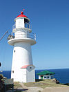
Central Coast Sandy Cape • Lady Elliot Island • Old Burnett Heads • New Burnett Heads • Bustard Head • North Reef • Sea Hill • Cape CapricornNorth Coast Flat Top Island • Pine Islet • Creal Reef • Dent Island • Cape Bowling Green • Cape Cleveland • Bay RockFar North Coast Fitzroy Island • Low Isles • Grassy Hill • Archer Point • Wharton ReefTorres Strait Wyborn Reef • Eborac Island • Goods Island • Booby IslandSee also: List of lighthouses and lightvessels in AustraliaCategories:- Lighthouses in Queensland


Wikimedia Foundation. 2010.