- Collingullie
-
Collingullie
New South Wales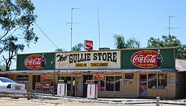
General Store at Collingullie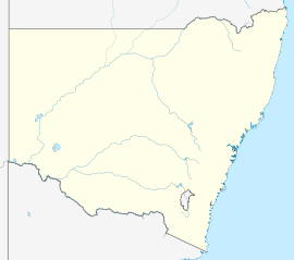
 Collingullie
Population: 399 (2006 census)[1] Postcode: 2650 Location: - 482 km (300 mi) from Sydney
- 27 km (17 mi) from Wagga Wagga
- 43 km (27 mi) from Lockhart
- 22 km (14 mi) from Galore [2]
LGA: City of Wagga Wagga County: Mitchell State District: Wagga Wagga Federal Division: Riverina Collingullie /ˈkɒlɪn.ɡʌli/ is a village 26 kilometres (16 mi) north-west of Wagga Wagga in the Riverina region of New South Wales, Australia. The village is located on the Sturt Highway, between Wagga Wagga and Narrandera, at the crossroads with the road to Lockhart.
At the 2006 census, Collingullie had a population of 399 people.[1] The name, Collingullie, could have derived from an Aboriginal word meaning 'boggy ground'.[3]
Collingullie Post Office opened on 1 August 1879 and closed in 1982.[4] The town's school, Collingullie Public School which has 56 students, is located on Urana Street.[5]

References
- ^ a b Australian Bureau of Statistics (25 October 2007). "Collingullie (State Suburb)". 2006 Census QuickStats. http://www.censusdata.abs.gov.au/ABSNavigation/prenav/LocationSearch?collection=Census&period=2006&areacode=SSC16753&producttype=QuickStats&breadcrumb=PL&action=401. Retrieved 12 July 2009.
- ^ Travelmate
- ^ "Collingullie". Geographical Names Board of New South Wales. http://www.gnb.nsw.gov.au/name_search/extract?id=JPIOlMUlTR. Retrieved 12 July 2009.
- ^ Premier Postal History. "Post Office List". https://www.premierpeostal.com/cgi-bin/wsProd.sh/Viewpocdwrapper.p?SortBy=NSW&country=. Retrieved 2009-06-11.
- ^ "Collingullie Public School". New South Wales Public Schools. http://www.schools.nsw.edu.au/schoolfind/locator/?section=showRecord&code=1591. Retrieved 2009-07-17.
Coordinates: 35°5′19.11″S 147°7′44.52″E / 35.0886417°S 147.1290333°E
Suburbs and Towns in the City of Wagga Wagga Local Government Area Suburbs: Ashmont · Bomen · Bourkelands · Boorooma · Cartwrights Hill · Charles Sturt University · Downside · East Wagga Wagga · Estella · Eunanoreenya · Forest Hill · Glenfield Park · Gobbagombalin · Gregadoo · Gumly Gumly · Kapooka · Kooringal · Lake Albert · Lloyd · Moorong · Mount Austin · North Wagga Wagga · San Isidore · Springvale · The Gap · Tatton · Tolland · Turvey Park · Wagga Wagga
Outlying Towns: Alfredtown · Burrandana · Collingullie · Currawarna · Galore · Humula · Ladysmith · Mangoplah · Oura · Tarcutta · UranquintyMain Article: Local Government Areas of New South WalesCategories:- Towns in New South Wales
- Wagga Wagga
- Towns in the Riverina


Wikimedia Foundation. 2010.