- Unorganized South East Cochrane District
-
Unorganized Cochrane South East Part — Unorganized territory — ONT Railway crossing in Bourkes
 Unorg. Cochrane SE Part
Coordinates: 48°18.5′N 80°14′W / 48.3083°N 80.233°W Country  Canada
Province  Ontario
District Cochrane Settled Government - Federal riding Timmins—James Bay - Prov. riding Timmins—James Bay Area[1] - Land 53.14 km2 (20.5 sq mi) Population (2006)[1] - Total 25 - Density 0.5/km2 (1.3/sq mi) Time zone EST (UTC-5) - Summer (DST) EDT (UTC-4) Postal Code Area code(s) 705 Unorganized Cochrane South East Part is an unorganized area in the Canadian province of Ontario, encompassing the small portion of the Cochrane District, immediately surrounding Highway 11 at the division's southern boundary with the Timiskaming District, which is not part of the municipality of Black River-Matheson.[2]
The division had a population of 25 in the Canada 2006 Census, and a land area of 53.14 square kilometres.[1] The main settlement in the division is the community of Bourkes.
Demographics
Population:[3]
- Population in 2006: 25
- 2001 to 2006 population change: 19.0 %
- Population in 2001: 21
- Population in 1996: 29
- Population in 1991: 38
Private dwellings, excluding seasonal cottages: 12 (total: 22)
References
- ^ a b c Statistics Canada 2006 Census - Cochrane, Unorganized, South East Part community profile
- ^ GeoSearch 2006
- ^ Statistics Canada: 1996, 2001, 2006 census

Black River-Matheson Black River-Matheson 
Black River-Matheson  Unorg. South East Cochrane

Unorg. West Timiskaming Kirkland Lake City 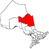
Towns Townships First Nations reserves Abitibi 70 • Constance Lake 92 • Factory Island 1 • Flying Post 73 • Fort Albany 67 • Moose Factory 68 • New Post 69 • New Post 69AUnorganized territories North Part • South East Part • South West PartSee also: Communities in Cochrane District • Census divisions of Ontario Coordinates: 48°18′30″N 80°14′00″W / 48.30833°N 80.2333333°W
Categories:- Unorganized areas in Ontario
- Cochrane District, Ontario
- Northern Ontario geography stubs
- Population in 2006: 25


Wikimedia Foundation. 2010.