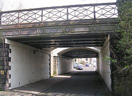
Cleckheaton Central railway station

Cleckheaton Central railway station
Cleckheaton-Station-entrance-by-Betty-Longbottom.jpg
The entrance to the central island platform was on the left between the two bridges.
Location
Place Cleckheaton
Area Kirklees
Coordinates 53°43′28″N 1°42′57″W / 53.724380°N 1.715723°W / 53.724380; -1.715723Coordinates: 53°43′28″N 1°42′57″W / 53.724380°N 1.715723°W / 53.724380; -1.715723
Grid reference SE188253
Operations
Original company Lancashire and Yorkshire Railway
Pre-grouping LNWR
Post-grouping LMS
Platforms 2 (removed)
History
1847 opened
14 June 1965 closed (passengers)
May 1969 closed (goods)
Disused railway stations in the United Kingdom
Closed railway stations in Britain
A B C D–F G H–J K–L M–O P–R S T–V W–Z
Portal icon UK Railways portal
[v · d · e]Railways in North Kirklees (Past, present and future)
Legend
Unknown BSicon "exCONTg"
To Bradford
Birstall Town
Unknown BSicon "exSTRrg" Unknown BSicon "exBHFq" Unknown BSicon "exKRZo" Unknown BSicon "exCONTl"
To Leeds
Gomersal
Unknown BSicon "exBHF" Unknown BSicon "exBHF"
Howden Clough
Lower Birstall
Unknown BSicon "exSTR" Unknown BSicon "exKBHFa" Unknown BSicon "exBHF"
Upper Batley
Unknown BSicon "exSTR" Unknown BSicon "exSTR" Unknown BSicon "exSTR" Continuation backward
To Leeds
Carlinghow
Unknown BSicon "exSTR" Unknown BSicon "exBHF" Unknown BSicon "exSTRlf" Unknown BSicon "eKRZu" Unknown BSicon "exSTRlg"
Unknown BSicon "exSTR" Unknown BSicon "exSTRlf" Unknown BSicon "exSTRq" Unknown BSicon "eABZdg" Unknown BSicon "exSTRrf"
Unknown BSicon "exSTR" Track turning from left Track turning right
To Bradford
Unknown BSicon "exCONTg" Unknown BSicon "exSTR" Unknown BSicon "eABZrg" Unknown BSicon "exCONTl"
To Leeds
Cleckheaton Central
Unknown BSicon "exBHF" Unknown BSicon "exBHF" Unknown BSicon "eABZld" Unknown BSicon "exSTRq" Unknown BSicon "exSTRlg"
Cleckheaton Spen
Unknown BSicon "exSTR" Unknown BSicon "exSTR" Station on track Unknown BSicon "exSTR"
Batley
Liversedge Central
Unknown BSicon "exBHF" Unknown BSicon "exBHF" Straight track Unknown BSicon "exSTR"
Liversedge Spen
Unknown BSicon "exSTR" Unknown BSicon "exSTR" Unknown BSicon "xvSTRa" Unknown BSicon "exBHF"
Chickenley Heath
Heckmondwike Central
Unknown BSicon "exBHF" Unknown BSicon "exBHF" Unknown BSicon "xvÜWBl" Unknown BSicon "exSTR"
Heckmondwike Spen
Batley Carr
Unknown BSicon "exSTR" Unknown BSicon "exSTR" Unknown BSicon "vxHST-STR" Unknown BSicon "exCONTf"
To Wakefield
Unknown BSicon "exSTR" Unknown BSicon "exSTR" Unknown BSicon "vxSTR-eHST"
Staincliffe and Batley Carr
Unknown BSicon "exSTR" Unknown BSicon "exSTR" Unknown BSicon "vSTRxl-KRZo" Unknown BSicon "exBHFq" Unknown BSicon "exSTRlg"
Dewsbury Central
Unknown BSicon "exSTR" Unknown BSicon "exSTR" Straight track Unknown BSicon "exSTRrg" Unknown BSicon "exABZrf"
Unknown BSicon "exABZlf" Unknown BSicon "exSTRl+r" Unknown BSicon "exSTRlg" Straight track Unknown BSicon "exSTR" Unknown BSicon "exBHF"
Earlsheaton
Unknown BSicon "exSTRrg" Unknown BSicon "exKRZu" Unknown BSicon "exKRZu" Unknown BSicon "exABZrf" Straight track Unknown BSicon "exSTR" Unknown BSicon "exCONTf"
To Wakefield
Dewsbury Wellington Road
Unknown BSicon "exSTR" Unknown BSicon "exSTR" Unknown BSicon "exABZrg" Unknown BSicon "exSTRrf" Station on track Unknown BSicon "exSTRlf" Unknown BSicon "exSTRlg"
Ravensthorpe Lower
Unknown BSicon "exSTR" Unknown BSicon "exSTR" Unknown BSicon "exBHF" Straight track Unknown BSicon "exKBHFa" Unknown BSicon "exSTR"
Dewsbury Market Place
Northorpe Higher
Unknown BSicon "exBHF" Unknown BSicon "exBHF" Unknown BSicon "exSTRlf" Unknown BSicon "exSTRlg" Straight track Unknown BSicon "exABZrg" Unknown BSicon "exSTRrf"
Northorpe North Road
Unknown BSicon "exSTR" Unknown BSicon "exSTR" Track turning from left Unknown BSicon "xKRZu" Track turning right Unknown BSicon "exSTR" Continuation backward
To Wakefield
Ravensthorpe
Unknown BSicon "exSTR" Unknown BSicon "exSTR" Station on track Unknown BSicon "exSTR" Unknown BSicon "exKDSTl" Unknown BSicon "exSTRl+r" Unknown BSicon "eABZrd"
Dewsbury Midland Goods
Battyeford
Unknown BSicon "exBHF" Unknown BSicon "xABZrg" Unknown BSicon "ABZ3rf" Unknown BSicon "eABZ3lf" Unknown BSicon "eBHFq" Unknown BSicon "xKRZo" Track turning right
Thornhill
Mirfield
Unknown BSicon "exSTR" Station on track Unknown BSicon "exCONTf"
To Royston and Notton
To Huddersfield
Unknown BSicon "exCONTf" Continuation forward
To Huddersfield

Cleckheaton Central railway station was a railway station serving the West Yorkshire town of Cleckheaton, England, until it was closed in the Beeching era, which saw the closure of many minor lines and stations around the United Kingdom through the 1960s. It has the distinction of being the only British railway station to have been stolen.[1]

History

The station was originally constructed by the Lancashire and Yorkshire Railway, which was absorbed by the LNWR in 1922 and subsequently the LMS in 1923 at grouping and finally to British Rail on nationalisation. It served traffic from Heckmondwike, Low Moor (near Bradford) and Mirfield. The Mirfield line opened in 1848 and through to Low Moor in 1849.[2] The last passenger train working was the service from Bradford on 12 June 1965 arriving at Cleckheaton at 11:21 p.m.; the station closed to freight traffic some four years later.

In 1972 a Dewsbury man appeared at Wakefield Crown Court; in the words of the prosecution counsel "what the case really comes to is that this man last August in effect stole Cleckheaton station".[1][3][4]

British Rail had contracted for the clearing of the site in August 1971, part of the deal being that the contractors would sell and retain the proceeds from disposal of the materials and scrap. On arrival, they discovered that the station and most of the material were already gone. It transpired that the man had been contracted by another firm to clear the site, had been advanced a sum for hire of plant, and had spent three weeks clearing the site. Subsequent efforts to trace the second firm failed, and the court found the man not guilty, deciding that he had been duped and left significantly out of pocket. The case is given as an example of the extension of the Theft Act 1968 to cover goods forming part of a property.[5]

Preceding station Disused railways Following station
Low Moor   L&Y   Liversedge Central

References

  1. ^ a b Spenborough Guardian
  2. ^ Lost Railways of Yorkshire
  3. ^ Body, Geoffrey: Railway Oddities, Tempus, 2007 ISBN 978-0-75244399-7
  4. ^ "Man denies theft of railway station", The Times, 25 April 1972, p. 3.
  5. ^ Storey & Lidbury, Criminal Law, Willan Publishing, 2004 ISBN 1-84392-100-6, p. 166

Wikimedia Foundation. 2010.

Игры ⚽ Поможем написать реферат

Look at other dictionaries:

  • Northorpe Higher railway station — Northorpe Higher Location Place Northorpe, West Yorkshire Area Kirklees Coordinates …   Wikipedia

  • Mirfield railway station — Mirfield The view from platform 3 Location …   Wikipedia

  • Dewsbury railway station — Dewsbury Dewsbury railway station, in June 2006 Location …   Wikipedia

  • List of British towns with no railway station — This is a list of towns and cities in Great Britain with no railway station. Despite closures in the 1960s, Great Britain has an extensive railway network and a large majority of towns have railway stations. Some of the few larger towns without… …   Wikipedia

  • Cleckheaton — Coordinates: 53°43′30″N 1°43′08″W / 53.725°N 1.719°W / 53.725; 1.719 …   Wikipedia

  • Liversedge — infobox UK place country = England official name= Liversedge latitude= 53.706667 longitude= 1.69 map type= West Yorkshire population= district= Kirklees metropolitan county= West Yorkshire region= Yorkshire and the Humber constituency westminster …   Wikipedia

  • Heckmondwike — infobox UK place country = England latitude= 53.7081 longitude= 1.6701 official name= Heckmondwike map type= West Yorkshire population = 11, 069 metropolitan borough= Kirklees metropolitan county = West Yorkshire region= Yorkshire and the Humber… …   Wikipedia

  • Bradford — For the larger local government district, see City of Bradford. For other uses, see Bradford (disambiguation). Coordinates …   Wikipedia

  • Leeds — This article is about the city of Leeds in England. For the administrative district, see City of Leeds. For other uses, see Leeds (disambiguation). Leeds   City and Metropolitan Borough   City of Leeds …   Wikipedia

  • Keighley — For the constituency of the same name, see Keighley (UK Parliament constituency). Coordinates: 53°52′01″N 1°54′40″W / 53.867°N 1.911°W / …   Wikipedia

Share the article and excerpts

Direct link
Do a right-click on the link above
and select “Copy Link”