- Chyama
-
Chyama — Village development committee — Location in Nepal
 Chyama
Coordinates: 27°32′N 86°08′E / 27.53°N 86.14°ECoordinates: 27°32′N 86°08′E / 27.53°N 86.14°E Country  Nepal
NepalZone Janakpur Zone District Dolakha District Population (1991) - Total 2,419 Time zone Nepal Time (UTC+5:45) Chyama is a village development committee in Dolakha District in the Janakpur Zone of north-eastern Nepal. At the time of the 1991 Nepal census it had a population of 2419 people living in 479 individual households.[1]
References
- ^ "Nepal Census 2001", Nepal's Village Development Committees (Digital Himalaya), http://www.digitalhimalaya.com/collections/nepalcensus/form.php?selection=1, retrieved 15 November 2009.
External links
Alampu, Babare, Bhedapu, Bhimeswor, Bhirkot, Bhusafeda, Bigu, Bocha, Bulung, Chankhu, Chhetrapa, Chilankha, Chyama, Dadhpokhari, Dandakharka, Fasku, Gairimudi, Gauri Sankar, Ghang Sukathokar, Hawa, Japhe, Jhule, Jhyaku, Jiri, Jugu, Kabhre, Kalingchok, Katakuti, Khare, Khupachagu, Laduk, Lakuri Danda, Lamabagar, Lamidada, Lapilang, Magapauwa, Makaibari, Mali, Malu, Marbu, Mati, Melung, Mirge, Namdu, Orang, Pawati, Sahare, Sailungeswor, Sunakhani, Sundrawati, Sureti, Susma Chhemawati, Syama, Thulopatal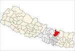 Categories:
- Populated places in Dolakha District
- Janakpur Zone geography stubs


Wikimedia Foundation. 2010.