- Church of St Mary the Virgin, Westonzoyland
-
Church of St Mary the Virgin 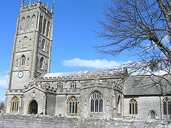
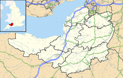
 Location within Somerset
General information Town or city Westonzoyland Country England Coordinates 51°06′31″N 2°55′35″W / 51.1087°N 2.9264°W Completed 13th century The Church of St Mary the Virgin in Westonzoyland, Somerset, England dates from the 13th century and has been designated as a Grade I listed building.[1]
St Mary’s Parish Church, with its 15th-century carved timber roof, has a link with two conflicts. It served as a prison for around 500 troops after the Battle of Sedgemoor [2] and now contains a corner dedicated to local airmen who lost their lives in 1918 and 1919 and post World War II in the early 1950s.
The four-stage tower, which dates from around 1470,[3] has an embattled parapet with quatrefoil arcading, and set-back buttresses which terminate in pinnacles on the bell-chamber stage.[1] There are six beels in the tower.[4]
The current clergyman is the Reverend Christopher Keys.
See also
- List of Grade I listed buildings in Sedgemoor
- List of towers in Somerset
References
- ^ a b "Church of St Mary the Virgin, Westonzoyland". Images of England. http://www.imagesofengland.org.uk/Details/Default.aspx?id=269612. Retrieved 5 March 2008.
- ^ Foard, Glen (2003). "Sedgemoor Battle". Battlefields Trust. http://www.battlefieldstrust.com/media/139.pdf. Retrieved 6 August 2008.
- ^ Poyntz Wright, Peter (1981). The Parish Church Towers of Somerset, Their construction, craftsmanship and chronology 1350 - 1550. Avebury Publishing Company. ISBN 0861275020.
- ^ "St Mary's Church, Westonzoyland". Zoyland heritage. http://www.zoylandheritage.co.uk/zoyland_heritage/st_marys_church.htm. Retrieved 18 September 2011.
Categories:- Church of England churches in Somerset
- 13th-century architecture
- Grade I listed churches
- Grade I listed buildings in Somerset
- Sedgemoor


Wikimedia Foundation. 2010.