- Church of St Martin, Kingsbury Episcopi
-
Church of St Martin 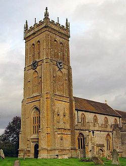
Location: Kingsbury Episcopi, Somerset, England Coordinates: 50°59′08″N 2°48′10″W / 50.98556°N 2.80278°WCoordinates: 50°59′08″N 2°48′10″W / 50.98556°N 2.80278°W Built: 14th century Listed Building – Grade I Designated: 17 April 1959[1] Reference #: 264374 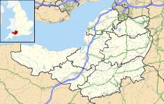
 Location of Church of St Martin in Somerset
The Church of St Martin in Kingsbury Episcopi, Somerset, England dates from the 14th century and has been designated as a Grade I listed building.[1]
The church which stands on the site of an earlier Saxon church of which no trace remains,[2] is dedicated to St Martin boasts an ornate Somerset Tower, 99 feet (30 m) tall, made of stone from nearby Ham Hill. There is a four bay aisled nave. Pevsner describes the chancel and chapels of the church as "gloriously lit" and advises visiting on a fine morning. He writes that the nave is older than the rest of the church, "no doubt of before 1400, and not yet infected with the later exuberance" of the Late Perpendicular style of the tower and other parts of St Martin's.[3] Poyntz Wright suggests the 100 feet (30 m) high,[4] west tower was built in 1515.[5]
The four stage tower is supported by buttresses and has bands of blank quatrefoils, and is surmounted by battlements with pinnacles.[6]
The church was renovated between 1845 and 1849.[2]
The parish is part of the benefice of Kingsbury Episcopi, East Lambrook and Hambridge within the deanery of Crewkerne and Ilminster.[2]
See also
- List of Grade I listed buildings in South Somerset
- List of towers in Somerset
References
- ^ a b "Church of St Martin". Images of England. http://www.imagesofengland.org.uk/details/default.aspx?id=264374. Retrieved 24 January 2008.
- ^ a b c "St Martin's, Kingsbury Episcopi". Church of England. http://www.achurchnearyou.com/kingsbury-episcopi-st-martin/. Retrieved 1 October 2011.
- ^ Pevsner, Nikolaus (1958). The buildings of England, South and West Somerset. Penguin Books (Reprinted by Yale Univ Press, 2003).
- ^ "Huish Episcopi cum Langport". Langport Area Team Ministry. http://www.langport-somerset.btck.co.uk/HuishEpiscopi. Retrieved 1 October 2011.
- ^ Poyntz Wright, Peter (1981). The Parish Church Towers of Somerset, Their construction, craftsmanship and chronology 1350 - 1550. Avebury Publishing Company. ISBN 0861275020.
- ^ "Kingsbury Episcopi, St. Martin". English church architecture. http://english-church-architecture.net/somerset/kingsbury%20episcopi/kingsbury_episcopi.htm. Retrieved 1 October 2011.
Categories:- Church of England churches in Somerset
- 14th-century architecture
- Grade I listed churches
- Grade I listed buildings in Somerset
- South Somerset


Wikimedia Foundation. 2010.