- Church of St James, Cameley
-
Church of St James 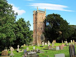
Location: Cameley, Somerset, England Coordinates: 51°18′57″N 2°33′37″W / 51.31583°N 2.56028°WCoordinates: 51°18′57″N 2°33′37″W / 51.31583°N 2.56028°W Built: 12th century Listed Building – Grade I Designated: 21 September 1960[1] Reference #: 32737 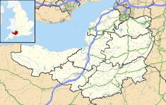
 Location of Church of St James in Somerset
The Church of St James is a redundant church in Cameley, Somerset, England, dating from the late 12th century. It has been designated by English Heritage as a Grade I listed building,[1] and is in the care of the Churches Conservation Trust.[2] It was declared redundant on 1 January 1980, and was vested in the Trust on 18 March 1981.[3]
The tower, probably from the 15th century with 19th-century restoration, is built of red Mendip stone which contrasts with the local blue lias limestone of the rest of the church. The tower contains a bell dating from 1779 and made by William Bilbie of the Bilbie family.[4]
There are fragments of wall paintings on the nave north and south walls. Fragments from the 12th to the 17th century have been identified, the most impressive being the fine early 17th-century Ten Commandments over the chancel arch, framed in twining leaves with cherubs' faces peering out. These remained hidden behind whitewash until the 1960s leading John Betjeman to describe it as "Rip Van Winkle's Church".[5]
 Fragment of wall painting
The west gallery is dated 1711 but with Jacobean style balusters and attached Charles I coat of arms. The south gallery is dated 1819. There are two early 19th-century monuments to the Rees-Mogg family on the north wall of the nave, and a brass plaque commemorating the nine people from the village who died in World War I.[6] The church is surrounded by trees.
Several of the monuments in the churchyard are Grade II listed.[7][8]
See also
- List of Grade I listed buildings in Bath and North East Somerset
- List of towers in Somerset
- List of churches preserved by the Churches Conservation Trust in South West England
References
- ^ a b "Church of St. James". Images of England. English Heritage. http://www.imagesofengland.org.uk/Details/Default.aspx?id=32737. Retrieved 2009-07-18.
- ^ St James' Church, Cameley, Somerset, Churches Conservation Trust, http://www.visitchurches.org.uk/Ourchurches/Completelistofchurches/St-James-Church-Cameley-Somerset/, retrieved 31 March 2011
- ^ (PDF) Diocese of Bath and Wells: All Schemes, Church Commissioners/Statistics, Church of England, 2011, p. 1, http://www.churchofengland.org/media/810289/bath%20and%20wells%20-%20all%20schemes.pdf, retrieved 31 March 2011
- ^ Moore, James; Roy Rice & Ernest Hucker (1995). Bilbie and the Chew Valley clock makers. The authors. ISBN 0952670208.
- ^ Scott, Shane (1995). The hidden places of Somerset. Aldermaston: Travel Publishing Ltd. p. 22. ISBN 1902007018.
- ^ "Cameley WWI Ref: 7503". United Kingdom National Inventory of War Memorials. http://www.ukniwm.org.uk/server/show/conMemorial.7503/fromUkniwmSearch/1. Retrieved 2006-05-19.
- ^ "Group of 2 Tombs, 10 metres south of chancel". Images of England. English Heritage. http://www.imagesofengland.org.uk/Details/Default.aspx?id=32739. Retrieved 2009-07-18.
- ^ "Naish monument 2 metres south-east of south porch". Images of England. English Heritage. http://www.imagesofengland.org.uk/Details/Default.aspx?id=32738. Retrieved 2009-07-18.
Categories:- 12th-century architecture
- Grade I listed churches
- Grade I listed buildings in Somerset
- Churches preserved by the Churches Conservation Trust
- Church of England churches in Bath and North East Somerset


Wikimedia Foundation. 2010.